


EXPOSURE
The RMS Magazine with a unique perspective and clear mission “... to provide insight and analysis to help insurance and risk professionals innovate, adapt, and deliver.”

Insurance: The next 10 years
Mohsen Rahnama, Cihan Biyikoglu and Moe Khosravy of RMS look to 2029, consider the…
Times Square, New York City
Tag: TEXAS TECH UNIVERSITY
Bringing Clarity to Slab Claims
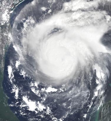
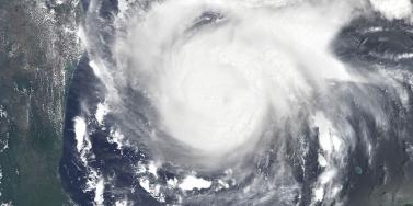
May 11, 2018How will a new collaboration between a major Texas insurer, RMS, Accenture and Texas Tech University provide the ability to determine with accuracy the source of slab claim loss? The litigation surrounding “slab claims” in the U.S. in the aftermath of a major hurricane has long been an issue within the insurance industry. When nothing is left of a coastal property but the concrete slab on which it was built, how do claims handlers determine whether the damage was predominantly caused by water or wind? The decision that many insurers take can spark protracted litigation, as was the case following Hurricane Ike, a powerful storm that caused widespread damage across the state after it made landfall over Galveston in September 2008. The storm had a very large footprint for a Category 2 hurricane, with sustained wind speeds of 110 mph and a 22-foot storm surge. Five years on, litigation surrounding how slab claim damage had been wrought rumbled on in the courts. Recognizing the extent of the issue, major coastal insurers knew they needed to improve their methodologies. It sparked a new collaboration between RMS, a major Texas insurer, Accenture and Texas Tech University (TTU). And from this year, the insurer will be able to utilize RMS data, hurricane modeling methodologies, and software analyses to track the likelihood of slab claims before a tropical cyclone makes landfall and document the post-landfall wind, storm surge and wave impacts over time. The approach will help determine the source of the property damage with greater accuracy and clarity, reducing the need for litigation post-loss, thus improving the overall claims experience for both the policyholder and insurer. To provide super accurate wind field data, RMS has signed a contract with TTU to expand a network of mobile meteorological stations that are ultimately positioned in areas predicted to experience landfall during a real-time event. “Our contract is focused on Texas, but they could also be deployed anywhere in the southern and eastern U.S.,” says Michael Young, senior director of product management at RMS. “The rapidly deployable weather stations collect peak and mean wind speed characteristics and transmit via the cell network the wind speeds for inclusion into our tropical cyclone data set. This is in addition to a wide range of other data sources, which this year includes 5,000 new data stations from our partner Earth Networks.” The storm surge component of this project utilizes the same hydrodynamic storm surge model methodologies embedded within the RMS North Atlantic Hurricane Models to develop an accurate view of the timing, extent and severity of storm surge and wave-driven hazards post-landfall. Similar to the wind field modeling process, this approach will also be informed by ground-truth terrain and observational data, such as high-resolution bathymetry data, tide and stream gauge sensors and high-water marks. “The whole purpose of our involvement in this project is to help the insurer get those insights into what’s causing the damage,” adds Jeff Waters, senior product manager at RMS. “The first eight hours of the time series at a particular location might involve mostly damaging surge, followed by eight hours of damaging wind and surge. So, we’ll know, for instance, that a lot of that damage that occurred in the first eight hours was probably caused by surge. It’s a very exciting and pretty unique project to be part of.”
