South Carolina Floods: The Science Behind the Event and What It Means for the Industry
Jeff WatersOctober 08, 2015
South Carolina recently experienced one of the most widespread and intense multi-day rain events in the history of the Southeast, leaving the industry with plenty to ponder.
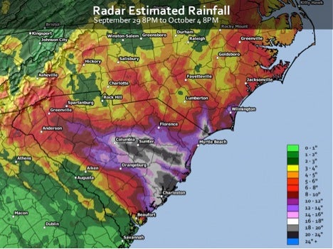
Parts of the state received upwards of 27 inches (686 mm) of rain in just a four day period, breaking many all-time records, particularly near Charleston and Columbia (Figure 1). According to the National Oceanic and Atmospheric Administration, rainfall totals surpassed those for a 1000-year return period event (15-20 inches (381-508 cm)) for parts of the region. As a reminder, a 1000-year return period means there is a 1 in 1000 chance (0.1%) of this type of event occurring in any year, as opposed to once every thousand years.
Figure 1: Preliminary radar-derived rainfall totals (inches), September 29-October 4. Source: National Weather Service Capital Hill Weather Gang.
The meteorology behind the event
As Hurricane Joaquin tracked north through the Atlantic, remaining well offshore, a separate non-tropical low pressure system positioned itself over the Southeast U.S. and essentially remained there for several days. A ridge of high pressure to the north acted to initiate strong onshore windflow and helped keep the low-pressure system in place. During this time, it drew in a continuous plume of tropical moisture from the tropical Atlantic Ocean, causing a conveyor belt of torrential rains and flooding throughout the state, from the coast to the southern Appalachians.
Given the fact that Joaquin was in the area, the system funneled moist outflow from it as well, enhancing the onshore moisture profile and compounding its effects. It also didn’t help that the region had experienced significant rainfall just a few days prior, creating near-saturated soil conditions, and thus, minimal absorption options for the impending rains.
It’s important to note that this rain event would have taken place regardless of Hurricane Joaquin. The storm simply amplified the amount of moisture being pushed onshore, as well as the corresponding impacts. For a more detailed breakdown of the event, please check out this Washington Post article.
Notable impacts and what it means for the industry
Given the scope and magnitude of the impacts thus far, it will likely be one of the most damaging U.S. natural catastrophes of 2015. Ultimately, this could be one of the most significant inland flooding events in recent U.S. history.
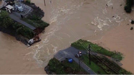
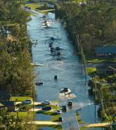
Figure 2: Aerial footage of damage from South Carolina floods. Source: NPR, SCETV.
Where do we go from here?
Similar to how Tropical Storm Bill reiterated the importance of capturing risk from tropical cyclone-induced rainfall, there is a lot to take away from the South Carolina floods.
First, this event underscores the need to capture interactions between non-tropical and tropical systems when determining the frequency, severity, and correlation of extreme precipitation events. This combined with high resolution terrain data, high resolution rainfall runoff models, and sufficient model runtimes will optimize the accuracy and quality of both coastal and inland flood solutions.
Next, nearly 20 dams have been breached or failed thus far, stressing the importance of developing both defended and undefended views of inland flood risk. Understanding where and to what extent a flood-retention system, such as a dam or levee, might fail is just as imperative as knowing the likelihood of it remaining intact. It also highlights the need to monitor antecedent conditions in order to properly assess the full risk profile of a potential flood event.
The high economic-to-insured loss ratio that is likely to result from this event only serves to stress the need for more involvement by private (re)insurers in the flood insurance market. NFIP reform combined with the availability of more advanced flood analytics may help bridge that gap, but only time will tell.
Lastly, although individual events cannot be directly attributed to climate change, these floods will certainly fuel discussions about the role it has in shaping similar catastrophic occurrences. Did climate change amplify the effects of the flooding? If so, to what extent? Will tail flood events become more frequent and/or more intense in the future due to a rising sea levels, warming sea surface temperatures, and a more rapid hydrologic cycle? How will flood risk evolve with coastal population growth and the development of more water impermeable surfaces?
This event may leave the industry with more questions than answers, but one stands out above the rest: Are you asking the right questions to keep your head above water?
Share:
You May Also Like
September 27, 2023
Moody’s RMS North Atlantic Hurricane Models: Five Reasons Why Version 23 is the Right Model to Navigate a Challenging Market
Staff Product Manager, Model Product Management, Moody's RMS
Jeff Waters joined Moody's RMS in 2011 and is based in Bethlehem, PA. As part of the Product Management team, he is responsible for product management of the Moody's RMS North Atlantic Hurricane Models.
Jeff provides technical expertise and support regarding catastrophe model solutions and their applications throughout the (re)insurance industry. He also generates product requirements for future updates and releases, and helps develop the overall product strategy, messaging, thought leadership, and collateral to ensure its commercial and technical success.
Waters’ background is meteorology and atmospheric science with a focus in tropical meteorology and climatology. Jeff holds a B.S. in Geography/Meteorology from Ohio University (’09), and a M.S. in Meteorology from Penn State University (’11). He is a member of the American Meteorological Society, the International Society of Catastrophe Managers, and the U.S. Reinsurance Under 40s Group, Inc


