Hurricane Ian: Strongest Hurricane in Southwest Florida Since 2004
Jeff WatersSeptember 29, 2022
The eighth named tropical storm of the current North Atlantic hurricane season, Major Hurricane Ian, made landfall as a Category 4 (Saffir-Simpson Hurricane Windscale) major hurricane near Cayo Costa, Florida at 19:05 UTC (15:05 Eastern Time ET) on Wednesday, September 28.
Ian remerged into the southeast Gulf of Mexico after leaving Cuba as a Category 3 storm on Tuesday, September 27, and strengthened owing to warm sea surface temperatures and generally low vertical wind shear. It completed an eyewall replacement cycle during the early hours of Wednesday, September 28, and rapidly strengthened into a Category 4 major hurricane intensity some hours later by 09:00 UTC (04:00 ET).
As it neared southwest Florida it continued to intensify and attained a peak intensity of 155 miles per hour (250 km/h) at 12:00 UTC (07:00 ET), and maintained this intensity for just over four hours until the center of the system made landfall.
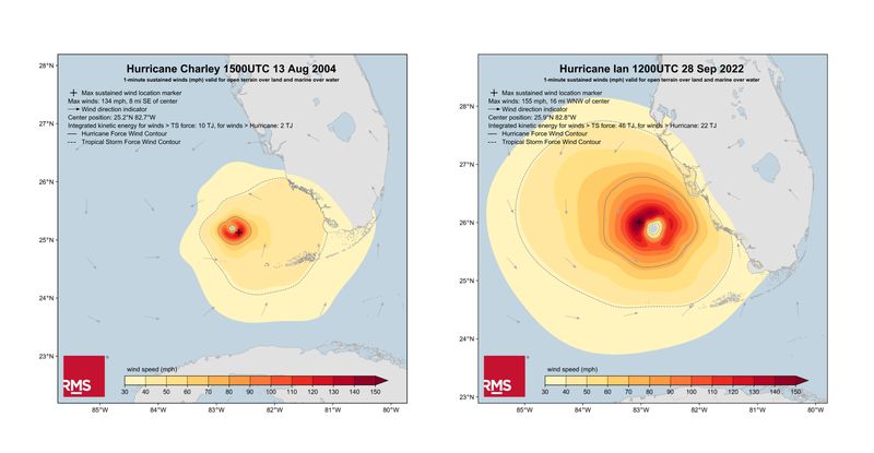
Close to Charley’s Landfall
Its landfall location near the barrier island of Cayo Costa in Lee County, some eight miles west of the city of Fort Myers (pop. ~86,000), was almost identical to where Hurricane Charley made landfall in August 2004 as a Category 4 event, the last time a major hurricane had hit Florida’s west coast.
Despite similar landfall locations, Ian and Charley were different in a couple of notable ways. First, Ian exhibited a much larger wind field and radius of maximum winds. Consequently, Ian’s maximum integrated kinetic energy (IKE) – a metric designed to convey the destructive potential of a windstorm – was more than four times that of Charley (46 terajoules - TJ to 10 TJ) – see the RMS HWind footprints below.
Second, Ian tracked much more slowly across Florida after landfall compared to Charley, amplifying the effects of wind and water.
Ian had estimated maximum sustained wind speeds of 150 miles per hour (240 km/h) at landfall, just below Category 5 with a central pressure of 940 hPa. The National Weather Service (NWS) Tampa Bay local office reported provisional peak wind gusts of 140 miles per hour (225 km/h) in Cape Coral, Lee County.
RMS HWind wind field snapshots for Hurricane Charley (left) and Hurricane Ian (right)
Ian gradually weakened post-landfall and tracked slowly east-northeast across central Florida. As of 09:00 UTC (05:00 ET) on Thursday, September 29, Ian weakened back to tropical storm intensity, and the center of Ian emerged off the east coast of Florida and into the North Atlantic. Some slight re-intensification is forecast, and Ian could be near hurricane strength when it approaches the coast of South Carolina on Friday, September 30.
Hurricane Ian delivered destructive hurricane-force winds that have impacted a broad swathe of central Florida, accompanied by severe and life-threatening storm surge inundation of 8 to 10 feet (2.4 to 3.0 m) above ground level, along with destructive waves ongoing along the southwest Florida coastline.
The full extent of the damage is expected to be known in the coming days once cut-off areas are reached, telecommunications are restored, and official damage assessments are conducted.
Emergency Declarations, Storm Surge, and Initial Damages
A Federal Emergency Declaration is in place for Florida, allowing for federal funding for nine impacted counties. Florida Governor DeSantis received a Major Disaster Declaration from FEMA today (Thursday). Twenty-six counties across Florida have mandatory or voluntary evacuation orders in place.
Many counties close to the event’s landfall are completely without power, and more than 2.6 million power outages have been reported, immobilizing over 42,000 personnel to restore power. Boil water notices are in operation in many counties due to water system issues.
Nearly 4,000 flights into and out of Florida were canceled on September 28-29, and 24 counties have closed schools and colleges.
After landfall, Ian reached Matlacha and Pine Island, just to the west of Cape Coral (pop. ~190,000), with hurricane-force winds and dangerous storm surge, destroying the majority of buildings and boats. Lee County, which includes Fort Myers and Cape Coral, experienced hurricane-force winds and unprecedented storm surges, which have caused extensive infrastructure damage across the county.
Significant storm surge inundation was reported across Fort Myers. Reports indicate up to 5.8 feet (1.7 m) in places approximately two hours after landfall – a record storm surge in the area. This has led to widespread, significant flooding in Fort Myers.
First responders in Fort Myers reported flooded roads, downed powerlines and poles, downed traffic lights, destroyed vehicles, and collapsed buildings. A boat dock has washed up in the middle of downtown Fort Myers. Roger Desjarlais, County Manager for Lee County, reported that the damage had left the community "… in some respects, decimated."
Extensive storm surge inundation is reported across Naples, Florida (pop. ~21,000), around 15 miles southeast of Ian’s landfall location. Reports indicate up to 4.8 feet (1.15 m) in places before Ian made landfall.
On Wednesday, September 28, NOAA indicated that the water level reached more than 6 feet (1.8 m) above high tide level, a record storm surge in the area. This has led to widespread, significant flooding in Naples. Multiple reports suggest hospitals, fire stations, roads, and the Naples Municipal Airport EMS Station have been inundated with floodwater.
Moving north, significant damage to infrastructure is being reported in North Port (pop. ~69,000) and Venice (pop. ~23,000), and Sarasota Bradenton International Airport was closed from Wednesday, September 28, as the storm caused roof and content damage to the airport. Hurricane-force winds caused widespread damage in Bradenton (pop. ~58,000), including direct wind damage to buildings, and downed trees and powerlines
The Tampa Bay Metro area (pop. ~3.19 million) was spared the worst of the damage from Ian, according to local media reports, but damage assessments will commence today, Thursday, September 29. Widespread downed trees and power lines have been reported.
Record Rainfall and Flooding
In addition to wind and storm surge impacts, rainfall and corresponding inland flooding have also been a big factor in Ian. According to the NOAA Weather Prediction Center many coastal and inland areas in Florida have already experienced more than 12 inches of rain (304 mm), with some localized areas exhibiting nearly 20 inches (508 mm). Rainfall intensity has also been a storyline, where rainfall totals exceeded the 100-year return period over 1-hour and 24-hour periods in certain regions.
The United States Geological Service (USGS) has observed that rainfall at North Port was ~20 inches in less than 24 hours, corresponding to a return period that exceeds 1,000 years – all in just 24 hours in that region. The recorded rainfall intensity was more than two inches within 30 minutes between 5-6 p.m. ET.
Furthermore, major to record-breaking fluvial flooding was recorded and many rivers across Central and Northern Florida continue to peak at the time of publishing this blog.
Consequently, many parts of the state have experienced record pluvial and fluvial flooding, with additional flooding expected in the coming days as rivers continue to crest.
What’s Next for Ian?
Ian is forecast to approach the coast of South Carolina and make landfall on Friday, September 30, with the center moving farther inland across the Carolinas during the evening and overnight into Saturday, October 1.
Ian is expected to produce 4 to 8 inches of rainfall (100 to 200 mm) across coastal Georgia and Lowcountry of South Carolina, with localized maximum amounts of 12 inches (300 mm) possible in some areas. Widespread considerable flash, urban, and river flooding is expected across portions of southeast Georgia and east South Carolina on Friday, September 30.
It is an evolving picture as more details come through, and RMS Event Response will be conducting reconnaissance and assessments over the coming days. Please follow the RMS blog and social channels for more information, and clients can access the very latest event information on RMS Owl.
Staff Product Manager, Model Product Management, Moody's RMS
Jeff Waters joined Moody's RMS in 2011 and is based in Bethlehem, PA. As part of the Product Management team, he is responsible for product management of the Moody's RMS North Atlantic Hurricane Models.
Jeff provides technical expertise and support regarding catastrophe model solutions and their applications throughout the (re)insurance industry. He also generates product requirements for future updates and releases, and helps develop the overall product strategy, messaging, thought leadership, and collateral to ensure its commercial and technical success.
Waters’ background is meteorology and atmospheric science with a focus in tropical meteorology and climatology. Jeff holds a B.S. in Geography/Meteorology from Ohio University (’09), and a M.S. in Meteorology from Penn State University (’11). He is a member of the American Meteorological Society, the International Society of Catastrophe Managers, and the U.S. Reinsurance Under 40s Group, Inc