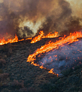
From soaring temperatures, drought, and wildfires in 2022, then floods, mudslides, and snow just into 2023, the western U.S., and particularly California has become a poster child for climatic extremes.
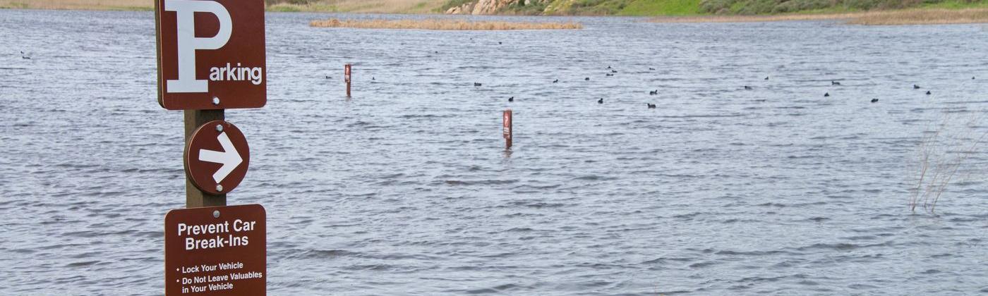
Before the recent California floods, 2022 was a year of soaring temperatures and sparse rainfall. The U.S. Drought Monitor (USDM), a weekly national drought map, showed for the week of December 13, 2022, that 80 percent of California was in severe drought – and 35 percent was rated as in extreme drought.
California’s Water Year 2022 which ended on September 30 recorded statewide precipitation at 76 percent of average. Reservoir storage across California was 69 percent of the average at that time of year. Lake Oroville, the State Water Project’s largest reservoir, sat at 64 percent of the average.
The current 2020-22 drought is the driest three-year period on record, breaking the record set by the previous 2013-15 drought. Heatwaves compounded the drought conditions in 2022, with high-temperature records broken in September as Sacramento reached 116 degrees Fahrenheit on September 6.
Endless Atmospheric Rivers
And then, from December 26, 2022, a series of extratropical cyclones enhanced by a band of high atmospheric water vapor (also known as an 'atmospheric river' or ARs) impacted the west coast of the U.S.
An AR can scale to 1000s of kilometers in length and 100s of kilometers in width and can transport amounts of rainfall or snow far greater than a typical storm.
AR after AR, fed from the tropical central Pacific traveled through to California over three weeks and resulted in wind damage, heavy rainfall, mudslides, debris flows, and heavy snow at high altitudes.
Total U.S. economic losses from the recent California flooding have been estimated by Moody’s RMS to be at US$5-7 billion, reflecting inland flood impacts for the U.S. and including damage to infrastructure.
Insured losses are anticipated to be between US$0.5-1.5 billion, including losses to the National Flood Insurance Program (NFIP) and the private flood market.
Records were broken. San Francisco recorded its wettest 10-day period since 1871 with 10.33 inches (262 mm) of rainfall between December 26 and January 4. San Francisco Airport saw 15.28 inches (388 mm) of rainfall over three weeks.
According to the National Weather Service (NWS), large parts of central California received over half of their annual normal precipitation in the 16 days after December 26.
One area of low pressure that impacted the west coast between January 4-5 underwent a period of rapid deepening (also known as 'bombogenesis'), where its central pressure dropped by 29 hPa in 24 hours.
This cyclone brought significant rainfall to low-level areas of California and southern Oregon, and heavy snowfall to higher altitudes. Wind gusts observations from the National Weather Service recorded the strongest wind gusts during this system in northern and interior California.
A peak wind gust of 132 miles per hour (212 km/h) was reported at Alpine Meadows, Placer County, California on January 5.
Then between January 8-16, three more 'atmospheric rivers' individually delivered anything from 7 to 18 inches of rainfall, in areas ranging from southern, central, and northern California, with rainfall again turning to heavy snow on higher ground – delivering up to three feet of snow on the Sierra Nevada range.
Mammoth Mountain has had 419 inches (10.6 meters) of snow this season, 204 inches in just 16 days, with ski resorts advising caution before visiting.
Rainfall amounts in excess of a 10-year return period were across most of the areas affected, and well in excess of 100 years in some areas, with multi-day cumulative amounts that could be more extreme because of the series of atmospheric rivers affecting the region.
Widespread Flooding
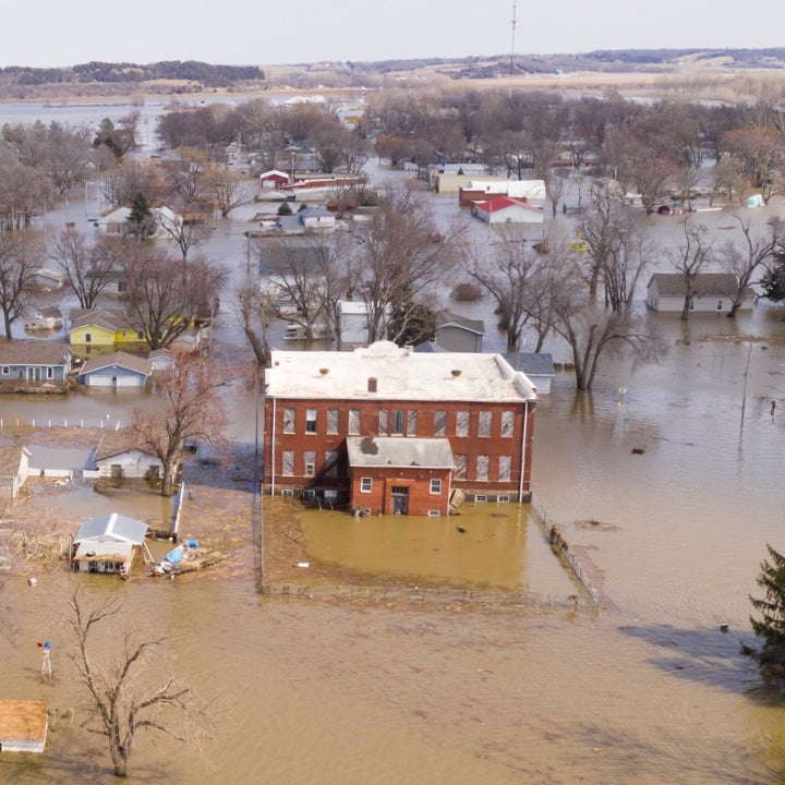
Dangerous, life-threatening flash flooding conditions occurred in southern Santa Barbara and central Ventura County after heavy rainfall in northern California on Tuesday, January 10. In Merced County, the entire community of Planada was evacuated due to rising floodwater as a levee was breached, flooding the whole area.
Flooding was dominated by widespread pluvial flooding combined with small-stream riverine flooding. Rivers and reservoirs also reached or exceeded their capacities leading to fluvial flooding. According to NWS and U.S. Geological Survey, at least nine rivers exceeded the flood stage, and 32 locations exceeded the flood monitor stage.
Downed trees contributed to more than 220,000 power outages across the state at its peak on Tuesday, January 10. Some 402 landslides have been recorded since Friday, December 30.
Learning from Past Events
One thing we’ve learned from this extreme rainfall and subsequent damage is that even perceived low-risk flood zones are still flood zones. If it rains, it can overflow. And with extreme drought, soil compaction means less infiltration and more runoff, hence less aquifer recharge and a higher risk of flooding.
What else have we learned? First, how did this event compare to previous rainfall-dominated events? The reference event is the largest flood in the recorded history of California, the 1862 'ARkStorm' which started on December 24, 1861, and lasted for 45 days with a series of rain and snowstorms.
During the ARkStorm, floodwaters inundated the Sacramento and San Joaquin valleys, which became an inland sea extending over 300 miles (480 km) in length and 20 miles (32 km) in breadth. The flood destroyed approximately one-quarter of the real estate in California. At least 4,000 people were killed.
Although some impacted areas are like the current event, the 1862 ARkStorm produced more severe precipitation, for example, 35 inches of precipitation in San Francisco compared to around 15 inches from this event. Another important mitigating factor for this ongoing event is the presence of flood defenses, which were mostly absent in 1862.
The impacted areas common to all these floods are Sacramento and San Joaquin Valleys, both located in the Central Valley, which has high tributary mountain watersheds. When intense precipitation occurs, these mountain watersheds bring a large amount of water quickly to the relatively flat and densely populated valleys.
As California is no stranger to atmospheric river events, in many ways, its flood response is shaped by this phenomenon. Elaborate flood control systems are now in place in the flood-prone Sacramento Valley and Delta and San Joaquin Valley.
But during events in 1986 and 1997, many levee failures occurred, causing extensive property damage and loss of lives. The 1986 flood in California and western Nevada, and the 1997 New Year’s Day flood in northern California, saw US$380 million and US$2 billion in damages respectively.
Second, does this extensive rainfall help ease the drought conditions? Not necessarily, as regions suffering drought conditions not only have depleted surface water reservoirs but also depleted aquifers. As mentioned earlier, droughts also lead to soil crusting compaction.
When it rains there is less infiltration, so less aquifer recharge. More runoff increases the risk of flooding as dry land doesn’t soak up much rainfall.
The rainfall has eased extreme drought conditions as the latest flood map from the USDM shows that 32 percent of California is now in severe drought, but no extreme drought. Although the state’s reservoirs have seen increases of between five and up to 30 percent, most are still under historical average capacity as some water has had to be released where overtopping became a risk.
The drought also had compounding impacts during this event, for example, many trees were very stressed from the dry condition and when impacted by the high velocity of water and wind, tree uprooting caused significant damage to homes, infrastructure, cars, and power infrastructure.
Third, what is the role of climate change in this extreme event? The degree to which climatic change plays a role in these events is complex to quantify, but there is growing evidence for climate change increasing the risk of severe flooding in general, and specifically for severe AR-type events in the Western U.S.
This is largely due to the combined effects of the atmosphere’s increased ability to hold moisture and the increasing prevalence of rain (instead of snow) in a warmer world.
Addressing the Protection Gap
And finally, this event has exposed a large protection gap. Of the 14.51 million homes in California (August 2022) there were only 193,281 residential NFIP policies in place, which equates to less than two percent. Policy take-up had even declined by five percent year-on-year.
There are several reasons that contribute to this low insurance take-up, and not all are unique to California. More than 50 percent of homeowners don’t realize that flood damage is not covered by a standard home insurance policy.
Homeowners have also canceled policies as premiums have risen, and even when a homeowner must buy a flood policy when taking out a federally approved loan, they cancel in the second year as there is no process to enforce it in following years.
Homeowners also take a ‘backward looking’ view, if their house has not been flooded in years, why would it flood now? The drought could also be a factor, as during dry years, cancellations increase, and conversely enrolments increase after a flood event after seeing the potential damage from floods.
This event shows that exposure falls outside a FEMA flood zone, maps in Los Angeles County show that just 3.9 percent of the land falls within the designated 100-year floodplain. These flood zones are outdated, infrequently reviewed, and use backward-looking data assuming climate stationarity and no change in the built environment.
With record-breaking flood events such as this, perhaps now is the time to reassess flood risk in the state.