California Wildfire: Another Record-Breaking Year?
Michael YoungAugust 02, 2018
Memories of last year’s Wine Country fires in Northern California and the Thomas Fire in Southern California are top of mind as we look at the unfolding wildfire events across the state, especially the notable Carr Fire to the northwest of the city of Redding in Shasta County, with a population of around 92,000.
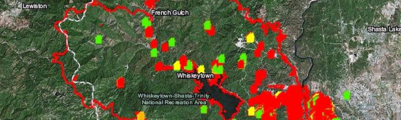
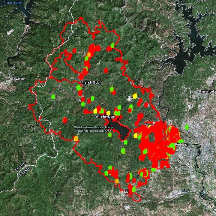
Initial observations show similarities to the Wine Country fires in terms of its speed and ferocity, as the Carr Fire spread rapidly overnight on Saturday, July 28, nearly doubling in size. As of 02:00 UTC on Thursday, August 2, the fire is reported to have burned about 121,000 acres (~49,000 hectares) — see figure one below, destroying 1,546 structures, damaging an additional 255 structures, and forcing the evacuation of 38,000 people, according to CAL FIRE and local officials.
Figure 1: CALFIRE Carr Fire Structure Status Information map as of 08:00 UTC, August 2, 2018. Red areas indicate more than 50 percent of structures destroyed. Source: CALFIRE
1,058 of the destroyed structures are residential, with over 1,600 further structures threatened. In the Lake Redding Estates neighborhood of Redding alone, over 45 homes were destroyed. Current news media reports that six people have been killed in the fire.
Wildfires are also affecting Mendocino County; the Ranch and River Fires, that comprise the Mendocino Complex Fire are located to the east of Ukiah, a small town with a population of 16,000. Ukiah is around forty miles north of Santa Rosa, which suffered severely from last year’s Wine Country fires. Both fires started in Mendocino County near midday local time on Friday July 27 and have since burned into neighboring Lake County; the Mendocino Complex Fire reportedly tripled in size during Saturday, July 28.
Although the damage caused by the Mendocino Complex Fire to date is low, local media reports that over 12,200 structures are threatened, and containment stands at ten percent.
Wildfire Activity up One Third Compared to 2017
In news reports, CNN has called the Carr Fire the sixth most destructive in California history, scorching an area larger than the entire city of Los Angeles, as 4,200 firefighters tackle a blaze in stifling heat, shifting winds, dry fuel and steep terrain. Containment, according to CAL FIRE, at the time of writing stood at 35 percent. The Carr Fire is currently one of sixteen wildfires that firefighters are attempting to contain across the state.
Although there is not an “official” start date to the California wildfire season, late-August and September — the approach to early fall, is usually the period when activity builds up, making this an intense pre-season. From January 1 to July 29, 2018, CAL FIRE reported that 292,455 acres have burnt, a figure that is still climbing rapidly with current events. This is up a third on the same period last year and nearly 150 percent higher than the five-year average.
If 2018 is already a third ahead in terms of acres burned compared to last year, this could be another record year, stealing the crown from the 2017 California wildfire season which was already a record-breaking on virtually every front. Some 1.25 million acres were torched by over 9,000 wildfire events during the period, with October to December seeing some of the most devastating fires ever recorded in the region.
For 2017, from an insurance perspective, according to the California Department of Insurance, as of January 31, 2018, insurers had received almost 45,000 claims relating to losses in the region of US$11.8 billion. These losses included damage or total loss to over 30,000 homes and 4,300 businesses.
What drove events last year? In a recent article in EXPOSURE magazine, Tania Schoennagel, research scientist at the University of Colorado, Boulder, stated that the start of the 2017 season presented seemingly benign conditions, but it rapidly became the third-largest wildfire year since 1960. “This was primarily due to rapid warming and drying in the late spring and summer of 2017, with parts of the West witnessing some of the driest and warmest periods on record during the summer and remarkably into the late fall.
“Additionally, moist conditions in early spring promoted build-up of fine fuels which burn more easily when hot and dry,” she added. “This combination rapidly set up conditions conducive to burning that continued longer than usual, making for a big fire year.”
Events are set to grow in severity and frequency as climate-related conditions create drier, more fire-conducive environments in North America. “Since 1985, more than 50 percent of the increase in the area burned by wildfire in the forests of the Western U.S. has been attributed to anthropogenic climate change,” states Schoennagel. “Further warming is expected, in the range of 2 to 4 degrees Fahrenheit in the next few decades, which will spark ever more wildfires, perhaps beyond the ability of many Western communities to cope.”
Mark Bove, research meteorologist, risk accumulation, Munich Reinsurance America, Inc also echoed the affect climate change could have on wildfires. “Climate change is causing California and the American Southwest to be warmer and drier, leading to an expansion of the fire season in the region,” says Bove. “In addition, warmer temperatures increase the rate of evapotranspiration in plants and evaporation of soil moisture. This means that drought conditions return to California faster today than in the past, increasing the fire risk.”
Wildfire risk modeling needs to advance; the range of factors such as the encroaching development of the Wildlife Urban Interface (WUI), the increasing value and quantity of both real estate and personal property, the presence of fire mitigation measures, and variables such as vegetation levels and building density, all need to be considered.
Granular modeling and analysis really is now required, to simulate stochastic or scenario events all the way from ignition through to spread, creating realistic footprints that can capture what the risk is and the physical mechanisms that contribute to its spread into populated environments, to enable insurers to make sense of a rapidly evolving, pervasive peril.
Share:
You May Also Like
March 16, 2022
U.S. Wildfire: Calculating the Value of Mitigation Benefits From Forest Treatment Strategies
Vice President, Model Product Management, Moody's RMS
Michael leads a team that establishes requirements and features for all of the Moody's RMS North and South America climate models. Michael's responsibilities include overseeing the submission of Moody's RMS products to regulatory reviewers, such as the Florida Commission on Hurricane Loss Projection Methodology (FCHLMP).
Michael has led studies of insurance mitigation programs for the state of Florida, as well as the World Bank. In his past 14 years at Moody's RMS, Michael has also worked as a lead wind vulnerability engineer, a director of claims and exposure development, and as the head of the mitigation practice. He has worked in commercial wind-tunnel laboratories doing studies on wind loads for a variety of buildings.
Before joining Moody's RMS, he was involved in the development of Federal Emergency Management Agency (FEMA) HAZUS-MH software for hurricane risk assessment, and he taught courses on the use of HAZUS hurricane and flood components. Michael has also led studies on mitigation cost effectiveness for building codes such as the 2001 Florida Building Code and the North Carolina Building Code.
Michael holds a bachelor's degree in Civil Engineering and a master's degree from the University of Western Ontario in Canada in Wind Engineering.