Canada Wildfire: The Lytton Tragedy and the Growing List of Surprise Wildfires
Michael YoungNovember 22, 2021
After a two-year period of below-average wildfire activity, the British Columbia Wildfire Service (BCWS) season summary report has concluded that 2021 was a “… tremendously challenging wildfire season.”
The BCWS confirmed that between April 1 and September 30 this year, 1,610 wildfires had burned 868,203 hectares (2.145 million acres) across British Columbia. This is in stark contrast to 2019 and 2020 where the total area burned in the province was less than 25,000 hectares (61,776 acres) per season – though both 2017 and 2018 were significant seasons, with over 1.2 million hectares (2.96 million acres), and a record-breaking 1.35 million hectares (3.34 million acres) burned respectively.
The agency confirmed it was challenging because of fire-fighting resource constraints due to COVID-19, and the sheer number of wildfires totaling over 300 at the height of the season. But the major challenge was the “heat dome” which caused the tragedy at Lytton and set the course for the rest of the season.
Extreme Wildfire Risk from the Start of the Season
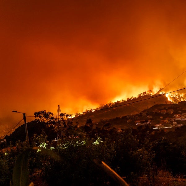
Extended drought conditions had continued through April into June, and many areas in the province were already on extreme fire hazard ratings when on June 29, 2021, the small town of Lytton in British Columbia, Canada, made it into the country’s record books for the third time in three days.
On Sunday, June 27, the temperature in Lytton reached 46.6 degrees Celsius (116 degrees Fahrenheit). On Monday, it reached 47.7 degrees Celsius (118 degrees Fahrenheit). And then on Tuesday, June 29, Lytton recorded the highest-ever temperature in Canada: 49.4 degrees Celsius (121 degrees Fahrenheit) on Tuesday, June 29. Renowned for water sports, Lytton has 250 residents and is located 261 kilometers (162 miles) by road from Vancouver on the 7,821-kilometer (4,860-mile) Trans-Canada Highway, in a valley where the Thompson River meets the Fraser River.
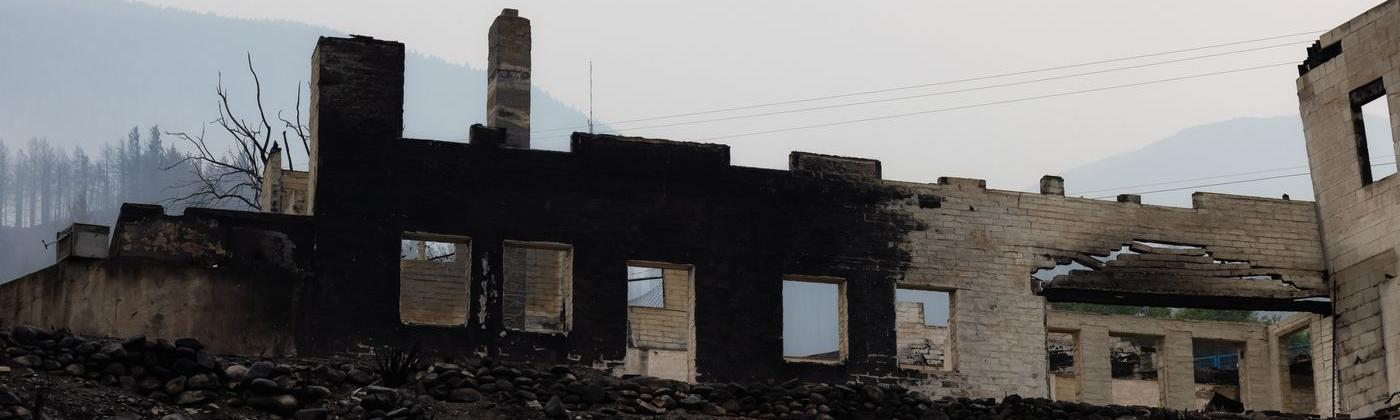
The next day, June 30, numerous fires just north of Lytton combined and ran out of control. Winds of up to 71 kilometers per hour (44 miles per hour) pushed the fire down the valley as fast as 10 to 19 kilometers (6 to 12 miles) per hour. Lytton’s mayor, Jan Polderman, told the media that it was only about 15 minutes between when he smelled smoke and began calling police and regional officials and when the town started going up in flames. By 6 p.m. local time, 90 percent of the town’s structures were destroyed. Around 1,000 residents across the area managed to evacuate to towns further south, but two fatalities were confirmed, and other residents were unaccounted for.
Living Under a Heat Dome
Warnings of a “historic and dangerous heatwave” for the northwestern U.S. and western Canada came from the U.S. National Weather Service and Environment Canada on June 23. By June 25, temperature records were being broken, and Canada was making headlines across the globe as it became stuck under a “heat dome,” with temperatures 11 to 19 degrees Celsius (52 to 55 degrees Fahrenheit) higher than usual.
Nighttime temperatures did not give respite and were the same as typical daytime temperatures. The size of this dome was vast, stretching from Oregon to southern Alaska. The heat dome moved slowly east, with temperatures across Canada unusually high for the next two weeks. The sweltering heat also brought its own casualties.
The term “heat dome” stirred global curiosity. According to the U.S. National Oceanic and Atmospheric Administration (NOAA), a heat dome “happens when strong, high-pressure atmospheric conditions combine with influences from La Niña, creating vast areas of sweltering heat that get trapped under the high-pressure dome.” Similar conditions have been seen before in western North America, in 2012 and 2018, and heat waves in Alaska, in 2019.
NOAA also states that the western Pacific’s temperatures have risen over the past few decades as compared to the eastern Pacific, which creates a strong temperature gradient. These pressure differences drive wind across the entire ocean in winter, causing more warm air, heated by the ocean surface, to rise over the western Pacific and decrease convection over the central and eastern Pacific. As prevailing winds move the hot air east, the northern shifts of the jet stream trap the air and move it toward land where it sinks, resulting in heat waves.
The size and intensity of Canada’s heat dome is what made it exceptional. Climate scientists stated that this heat dome would have been “virtually impossible” without climate change.
Heat Domes Exacerbate High Wildfire Risk
Soaring temperatures in themselves do not cause wildfires. It is worth remembering that wildfire activity is not a primary climate change variable but a consequence of weather variables. As temperatures soar, wildfire risk increases due to hot and dry weather, and as high temperatures persisted, the BCWS stated that during the first two weeks of July an average of 40 new wildfires started every day.
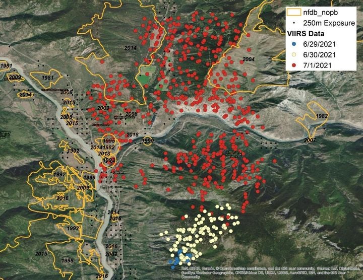
The region of the Lytton Fire is no stranger to wildfire, as previous fire footprints over the last 40 years show (Figure 1). What was striking was how wildfires that started just a couple of days before the catastrophe at Lytton had spread so rapidly and were driven into the valley. The Lytton Fire was one event within a backdrop of over 300 fires across British Columbia by July 11.
Figure 1: Comparison of the fire footprint as scanned by Visible Infrared Imaging Radiometer Suite (VIIRS) compared to historical footprints around Lytton between 1980 and 2018
What turns a wildfire into a catastrophe as seen in Lytton? Catastrophic wildfire risk will occur when hot and dry conditions together with extreme winds such as in this event promote a fast spread of the fire. The Dixie Fire, the largest California wildfire of the 2021 season and the largest-ever single (non-complex) fire at 389,837 hectares (963,308 acres), also accelerated exceptionally quickly.
What can homeowners and the insurance industry do to get prepared and plan for the next inevitable event, whether it is in Canada or the U.S.? With the complete destruction of the area, Lytton is now looking to rebuild as a net-zero community, attracting funding from multiple sources and placing fire resistance at the heart of the rebuild.
As our work with the Insurance Institute for Business and Home Safety (IBHS) shows, and is reflected in the mitigation modifiers within our wildfire models, some basic steps really help reduce a homeowner’s wildfire risk: implement defensible space around the property, remove flammable materials, and work out an escape plan.
For the insurance industry, events such as Lytton should act as another warning light on the wildfire-risk dashboard. It did not affect solvency for insurers, but it is yet another reminder that wildfire is a mainstream and growing peril. With fire management agencies such as BCWS, and CalFire reporting a season running over three times the five-year average in terms of area burnt – similar to other major perils, the risk needs to be thoroughly understood and managed.
Vice President, Model Product Management, Moody's RMS
Michael leads a team that establishes requirements and features for all of the Moody's RMS North and South America climate models. Michael's responsibilities include overseeing the submission of Moody's RMS products to regulatory reviewers, such as the Florida Commission on Hurricane Loss Projection Methodology (FCHLMP).
Michael has led studies of insurance mitigation programs for the state of Florida, as well as the World Bank. In his past 14 years at Moody's RMS, Michael has also worked as a lead wind vulnerability engineer, a director of claims and exposure development, and as the head of the mitigation practice. He has worked in commercial wind-tunnel laboratories doing studies on wind loads for a variety of buildings.
Before joining Moody's RMS, he was involved in the development of Federal Emergency Management Agency (FEMA) HAZUS-MH software for hurricane risk assessment, and he taught courses on the use of HAZUS hurricane and flood components. Michael has also led studies on mitigation cost effectiveness for building codes such as the 2001 Florida Building Code and the North Carolina Building Code.
Michael holds a bachelor's degree in Civil Engineering and a master's degree from the University of Western Ontario in Canada in Wind Engineering.