Latest RMS HWind Track Probability Analysis: Irma Shifts Further South and West Than Previous Forecasts
Michael KozarSeptember 07, 2017
23:30 UTC Thursday, September 7
Michael Kozar, senior modeler – Model Development, RMS
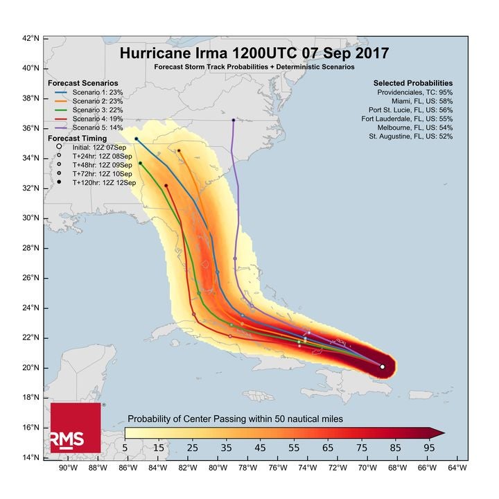
The RMS HWind team based in Tallahassee have released their latest track probability analysis of the current model forecasts. This analysis, based on forecast models initialized at 12:00 UTC today Thursday, shows that Irma’s projected path has shifted further south and west than the previous forecasts. The highest probabilities now run through southeastern Florida (as shown by the shaded data), with Miami having a nearly 60 percent chance of the storm passing within 50 nautical miles of the city.
Figure 1: Hurricane Irma forecast storm track probabilities and deterministic scenarios, initialized Thursday, September 7 at 12:00 UTC
Looking at the two largest cluster scenarios (forecast scenarios 1 and 2), these have Irma moving near or directly over the southern edge of the Florida Peninsula with impacts continuing into central Florida and up the Atlantic coastline — this corresponds well with the shaded density data shown in the image.
Uncertainty in when Irma will turn northwards is driving the different forecast tracks for U.S. impact, though regardless of exact track, impact to south Florida is likely, though still not completely certain as shown by the lower probability scenarios.
In terms of the power of Irma, using RMS HWind’s unique Integrated Kinetic Energy (IKE) metric for storm size and surge destructive potential, comparing Irma to Andrew using IKE provides a compelling representation of Irma’s destructiveness:
Irma has similar intensity to Andrew (1992) now, but five times more storm surge forcing than Andrew
In our latest HWind snapshot at 21:00 UTC, Irma is now at 112 terajoule (TJ) peak sustained wind near 170 miles per hour (mph), for comparison:
o Andrew at landfall was about 20 TJ when peak sustained wind was 170 mph
o Harvey at landfall was 30 TJ peak sustained wind was 130 mph
o Wilma (2005) at landfall was also about 120 TJ when peak sustained wind was 111 mph
For more information on RMS HWind, RMS clients can consult their account representatives for details on the latest RMS HWind updates.
Michael is a senior modeler on the RMS HWind team based at the Tallahassee, FL office. Michael has a bachelor's and a master's degree in Meteorology from Penn State University and a PhD in Meteorology from Florida State University. He has experience forecasting and analyzing tropical cyclone wind fields and has also studied interannual hurricane variability in the North Atlantic.