
U.S. Earthquake
Understand seismic hazard in the contiguous U.S., Alaska, and Hawaii with a view of risk that incorporates the latest scientific insights.

Comprehensive View of Seismic Hazard for the United States
The Moody's RMS U.S. Earthquake Model is part of the Moody's RMS North America Earthquake Models suite which offer seamless seismic source coverage across the U.S., Canada and Mexico. For the Moody's RMS U.S. Earthquake Model, this allows users to assess seismic events outside the U.S. border that have the potential to cause losses to a U.S. portfolio. This provides a more complete view of events impacting exposure within the country along with efficient rollup of multi-national portfolios.
Latest View of Hazard
Moody's RMS U.S. earthquake modeling includes the latest data from the U.S. Geological Survey (USGS) 2014 National Seismic Hazard Mapping Project (NSHMP), including data from the third Uniform California Earthquake Rupture Forecast (UCERF3), the 2013 USGS Quaternary Fault and Fold Database for Alaska, and the latest source information for Hawaii.
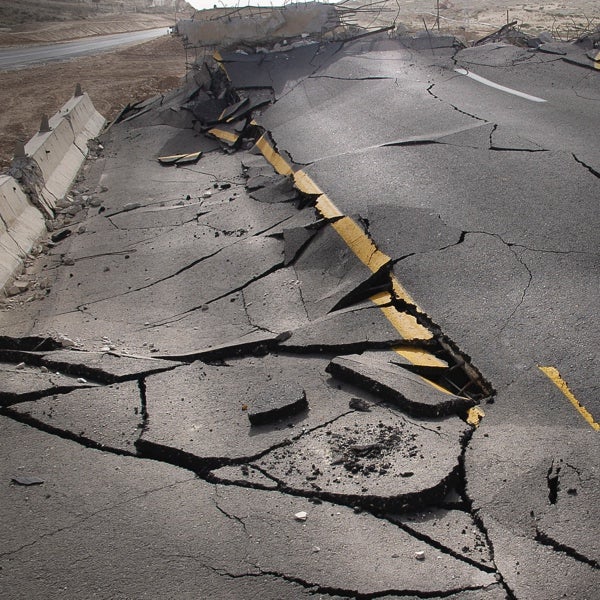
Analysis of Liquefaction Risk
Moody's RMS invested significant resources to understand the major effects of liquefaction from the 2010-2011 Canterbury Earthquake Sequence in New Zealand. Using billions of dollars of claims data from these events in New Zealand, Moody's RMS has transferred its knowledge to develop a new probabilistic liquefaction model that covers all of North America, including the United States.
High-Resolution Amplification Model
High-resolution amplification model used in U.S. Earthquake modeling reflects the latest ground motion prediction equations, incorporating new science to better differentiate risk based on local site conditions as well as detailed basin amplification models of key areas.
U.S. Earthquake Model
Comprehensive, high-resolution U.S. earthquake modeling, incorporating the latest science.
Related Products
Resources

The Mw7.1 – 2019 Ridgecrest (California) Earthquake Sequen...
The recent events that shook a relatively remote part of the Mojave Desert region of Eastern California provide an acute reminder of the major risk posed by earthquakes in the state. It has been a while now since California experienced a large earthquake, and the main event in this sequence – with a magnitude of Mw7.1, was the most powerful earthquake to occur in the state in twenty years. Since then, the field of seismology as well as earth scientific measuring capabilities have undergone quite substantial i...

Did Ridgecrest Increase the Chances of a Large Seismic Eve...
Interest in the 160-mile-long Garlock Fault, the second-largest fault in California, has been piqued recently after a Los Angeles Times article about deformation on the Garlock Fault due to the Ridgecrest sequence of events in July 2019. Since the publication of this article, RMS has received information requests focused around two main points. First, does RMS believe that Ridgecrest impacted the Garlock Fault (and possibly others), and has therefore increased the probability of a rupture there? Sec...

2018 USGS Hazard Map Updates: Is RMS Revising the U.S. Ear...
In March 2018, RMS hosted the U.S. Geological Survey (USGS) workshop at our Newark headquarters in California to discuss the interim updates planned for the 2018 USGS National Seismic Hazard Map Project (NSHMP). Details can be found in my previous blog: Are You Ready for an Interim USGS NSHM Update? The USGS informed the public and technical community about this interim update ahead of their regular six-year cycle of updates anticipated after 2020. The main purpose was to incorporate new ground motion mo...

Find the Model to Fit Your Needs
