Hurricane Ian Makes Final Landfall in South Carolina Accompanied With Strong Winds, Storm Surge, and Heavy Rainfall
Firas SalehSeptember 30, 2022
As Hurricane Ian departed into the Atlantic from Florida’s east coast at 12:00 UTC (08:00 Eastern Time ET) Thursday, September 29, it then regained hurricane intensity later that day at 21:00 UTC (17:00 ET).
It has made an unwelcome return; the National Hurricane Center (NHC) has announced that surface observations indicated that the center of Hurricane Ian made landfall on Friday, September 30, as a Category 1 hurricane at 14:05 ET (18:05 UTC) near Georgetown, South Carolina (pop, ~9,000).
It had maximum sustained winds of 85 miles per hour (140 km/h) and an estimated minimum central pressure of 977 mb (28.85 inches). The NHC has now stated that Hurricane Ian is now Post-Tropical Cyclone Ian as of 21:00 UTC, on Friday, September 30.
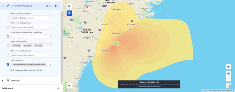
An RMS HWind wind field snapshot (below), integrated into the RMS ExposureIQ™ application, shows Hurricane Ian close to landfall.
ExposureIQ HWind Snapshot for Hurricane Ian at 18:00 UTC on Friday, September 30
The prospect of additional impacts from Ian represents a further jolt, after the destruction experienced especially through southwest Florida. The system is expected to bring a danger of life-threatening storm surge along the coasts of Georgia and the Carolinas, with surge heights of up to 7 feet (2.1 m) forecast along portions of the coastline between Edisto Beach and Little River Inlet, South Carolina.
Hurricane-force winds are impacting the immediate vicinity where Ian has made landfall, as well as the prospect of heavy rainfall of 4 to 8 inches (100 to 200 mm) in parts of northeast South Carolina, with local maximum amounts of 12 inches (300 mm) possible in some areas across Georgia, the Carolinas, and Virginia.
The system is also forecast to bring 3 to 6 inches of rainfall (75 to 150 mm) across parts of central South Carolina, North Carolina, and southern Virginia. This could result in considerable local urban flooding.
Rainfall intensity can have major impacts on the aging infrastructure in some regions. For example, South Carolina alone has more than 2,200 dams that are rated D+ by the American Society of Civil Engineers (ASCE). Some 24 percent are classified as High Hazard Potential Dams which according to the ASCE, in the event of failure, could cause catastrophic damage to infrastructure and property while also carrying the risk of injury and death to people.
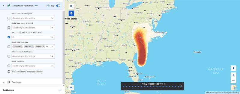
ExposureIQ Forecast Track Density for Hurricane Ian at 08:00 UTC on Friday, September 30
The end of Ian will be on Sunday, October 2 with rapid weakening expected after landfall, and Ian is forecast to become an extratropical low over North Carolina by tomorrow, Saturday, October 1. The low is then expected to dissipate by Sunday, October 2.
Significant Infrastructure Impact
The full extent of the damage in Florida is still coming together. Around 1.9 million people are without power across Florida as of today, Friday, September 30, with reports from the Governor of Florida suggesting that the electrical infrastructure in both Charlotte and Lee Counties are so badly damaged that they will need rebuilding. At least 12 wastewater treatment facilities in Florida have discharged waste due to excess water levels.
Fifty-nine school districts were closed today (Friday), together with eight ports, and transport is difficult as 42 major roads and bridges are currently damaged or flooded. A further 1,800 flights were canceled on Thursday, September 29, but most Florida airports are now starting to operate.
The Governor of Florida has addressed the significant impacts from Ian in Florida and expects "... there's going to be damage throughout the whole state." After initial surveys of some regions, the Governor reported that "... some of the damage was indescribable." Damage included residential properties destroyed by floods and hurricane-force winds, roads filled with damaged boats, and vehicles floating in flooded streets.
The President of the United States stated that Ian "… could be the deadliest hurricane in Florida's history." Media reports state that at least 21 fatalities have been confirmed across Florida. Over 700 people have been rescued across the state.
Destruction from Hurricane Ian
Starting close to the landfall location of Cayo Costa on a barrier island on Florida’s southwest coast, next in Hurricane Ian’s path were Pine Island and Matlacha, with the majority of buildings and boats reported destroyed. The Pine Island Bridge connecting the island to the city of Cape Coral (pop. ~190.000) has also been destroyed, as well as some small businesses along Pine Island Road.
For Lee County, which includes the cities of Cape Coral and Fort Myers (pop. ~83,000), the County Sheriff commenting on an initial damage assessment conducted on Thursday, September 29 reported that in the Fort Myers area, commercial buildings and residential properties had been "… completely washed away, with vehicles floating in the water and in the bay, and boats turned over."
Record-breaking storm surge inundation of up to 12 feet (3.6 m) in places has been reported by the media, with houses in the area removed from their foundations as a result. Extensive flooding has caused significant damage to Fort Myers, with vehicles, boats, and debris from buildings being carried through the flooded streets, as first responders in Fort Myers contend with flooded roads, downed powerlines, and poles, downed traffic lights, destroyed vehicles, and collapsed buildings.
The compound flooding from coastal storm surge and riverine flooding is expected to exacerbate these impacts, especially in highly urbanized watersheds that have a reduced hydrologic response time.
Around four hundred patients at two Fort Myers hospitals were evacuated because of water pressure losses. Fort Myers Marina has experienced unprecedented levels of destruction from hurricane-force winds and dangerous storm surges, and multiple buildings and businesses have been swept away by storm surges along Fort Myers Beach.
Initial reports suggest thousands of buildings have been inundated with floodwaters, particularly in Fort Myers, Naples, and Charlotte. Images show widespread destruction to residential properties in Bonita Springs, close to Fort Myers, with a mobile home park in Bonita Springs City almost completely washed away.
The Sanibel Causeway connecting the Sanibel and Captiva Islands to Fort Myers has sustained significant damage and has partially collapsed. Sanibel and Captiva Islands have been cut off from the mainland. Two fatalities have been reported in the city of Sanibel, with a further 12 people injured. Buildings and structures on Sanibel Island were heavily damaged by storm surge.
South of Fort Myers, the city of Naples experienced extensive storm surge inundation with reports on Wednesday, September 28 of up to 4.8 feet (1.5 m) in places - before Ian made landfall. NOAA indicated that the water level reached more than 6 feet (1.8 m) above high tide level, a record storm surge in the area.
This has led to widespread, significant flooding in Naples, including North Naples, Naples Park, and the Isles of Capri. Naples Pier has been destroyed, with hospitals, fire stations, and the Naples Municipal Airport EMS Station all inundated with floodwater.
North of Fort Myers, residential areas in Port Charlotte were inundated with floodwater after storm surges spread through the region on Thursday, September 29, and hurricane-force winds detached the roof of a hospital in Port Charlotte. Seven fatalities have been reported in Charlotte County.
State-wide Impact
The Tampa Bay Metro area (pop. ~3.19 million) was spared the worst of the damage from Ian, with damage assessments ongoing. Damage to residential and commercial properties due to downed trees and power lines has been reported.
Warnings of dangerous flooding in the Orlando Metro area (pop. ~2.6 million) are in place, with Avante and Orlo Vista experiencing extensive flooding. Heavy rainfall, up to 1 foot (300 mm) in 2 hours caused extensive flooding across Kissimmee, with 120 people rescued after buildings are inundated with floodwater.
The Florida National Guard sent 10 high-water trucks to help with rescues. Water Springs City experienced extreme water flooding. Altamonte Springs experienced extensive flash flooding from 15 inches (381 mm) of rain. The nearby Sunrise Community is completely inundated with floodwater.
Reports suggest up to 12 inches (300 mm) of rain has fallen in the Orlando metro area on Thursday, September 29, with an additional 4 inches (100 mm) of rainfall forecast in the area through the rest of Friday, September 30. The rainfall from Ian in Orlando corresponds to a 1-in-1000-year rainfall event according to NOAA’s backward-looking precipitation frequency estimates.
Inland areas with low National Flood Insurance Program (NFIP) penetration rates are also witnessing major flooding as many rivers continue to peak to historical water level records. Inland flooding in low flood insurance penetration areas is expected to have major financial implications to a large percent of homeowners that have no flood insurance coverage.
Looking across Florida, tornados have also caused damage. Tornados in the outer bands of the system caused extensive damage to a retirement community of more than 10,000 residents, and damaged at least five buildings, in Kings Point, Delray Beach City.
As always, it is an evolving picture as more details come through, and RMS Event Response will be conducting reconnaissance and assessments over the coming days with new insights shared directly into RMS ExposureIQ. Please follow the RMS blog and social channels for more information, and clients can access the very latest event information on RMS Owl.
Dr. Firas Saleh joined Moody's as Director of Model Product Management in 2020. He oversees Moody's RMS U.S. Inland Flood and Wildfire HD Models, working closely with clients and across Moody's functional teams on defining and executing the vision, strategy, and roadmap for Moody's RMS flood and wildfire products.
Firas holds a Ph.D. in Geosciences and Natural Resources from the University of Pierre et Marie Curie - Paris VI (Sorbonne Universités), France. He has a strong professional track record in the U.S. Federal Government, industry, and academia.
During his academic tenure at different institutes around the world, including the Paris School of Mines (Mines Paris-Tech), New Jersey Institute of Technology, and Stevens Institute of Technology, his research was focused on implementing quantitative forward-looking analytics to assess climate and weather-related physical risk and impacts on critical infrastructure resilience.
At Stevens, he was part of the team that pioneered and productized the coastal-inland operational flood forecast systems for Port Authority of NY-NJ critical facilities (JFK, LaGuardia, Newark, and Teterboro Airports) and NJ Transit. He has co-authored more than 30 publications in peer-reviewed articles, conference proceedings, and book chapters.
He also served as a Senior Commercial Specialist at the U.S. Embassy in Baghdad and Amman, the U.S. Commercial Service, and the U.S. Department of State. He received the U.S. Department of Commerce Gold Medal Award for his distinguished federal service in fostering collaboration between government and industry concerning water and construction. The Gold Medal is the highest honorary award from the U.S. Secretary of Commerce.