A Look Back at the 2011 Great East Japan (Tohoku) Earthquake
Chesley WilliamsMarch 10, 2021
Major earthquake disasters are fortunately rare, but when they happen, it is an opportunity to learn and continue to push the boundaries of earthquake science and engineering. Ten years ago, on March 11, 2011, at 2:46 p.m. local time, an M9.0 earthquake occurred offshore of the east coast of the Tohoku region on the island of Honshu, Japan. It was the most powerful earthquake ever recorded in the country.
The epicenter was 80 miles (130 kilometers) east of Sendai and 231 miles (373 kilometers) northeast of Tokyo. Ground shaking lasted for over five minutes in many areas, including Tokyo. The seafloor deformation associated with the subsea fault movement generated a devastating tsunami, impacting the eastern coast of the Tohoku region. This earthquake was so big that Earth’s day was shortened by 1.8 microseconds and shifted its figure axis by 7 inches (17 centimeters).
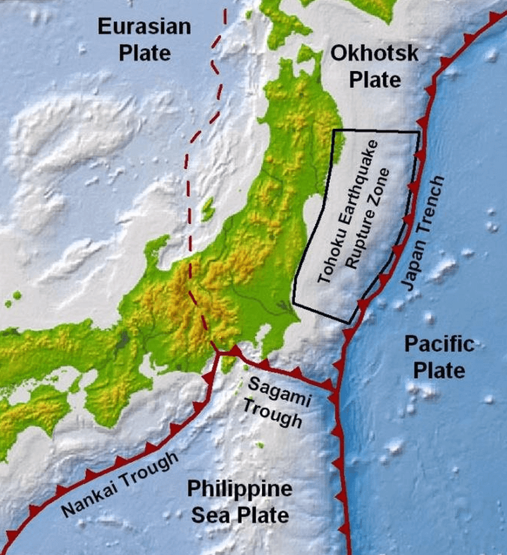
The M9.0 earthquake was located on the subduction interface plate boundary where the Pacific Plate is driven underneath Japan along the Japan Trench (see Figure 1). An event of this size was not anticipated. The 450-year historical earthquake record for the Japan Trench did not contain any earthquakes comparable to the size of the 2011 event in this region. The “maximum credible earthquake” along this section of the Japan Trench was previously considered to be M8.3.
Figure 1: Japan's tectonic setting, illustrating the three subduction zones (Nankai Trough, Sagami Trough, and the Japan Trench) based on plate boundaries from Bird (2003); the rupture zone of the 2011 Tohoku event is shown along the Japan Trench
Roughly 249 miles (400 kilometers) of the plate boundary ruptured due to a cascade of events on several adjacent fault ruptures, which had historically generated independent, smaller-sized earthquakes. The maximum fault displacement in the earthquake has been estimated to be as high 98 to 131 feet (30 to 40 meters), which explains the strong ground motions that radiated from the source as well as the extensive inundation zone generated by the tsunami.
The vertical displacement of the sea floor associated with the underlying unusually large fault movement triggered tsunami waves that propagated westward toward the Japan coastline and eastward across the Pacific Ocean.
The first tsunami wave reached the Japan coastline within 10 to 40 minutes after the earthquake. Coastal areas within Iwate, Miyagi, and Fukushima Prefectures experienced waves of over 16 feet (5 meters); in some areas waves were above 33 feet (10 meters), e.g., Miyako District in Iwate Prefecture; and in localized areas waves were more than 49 feet (15 meters), e.g., Ofunato District in Iwate Prefecture.
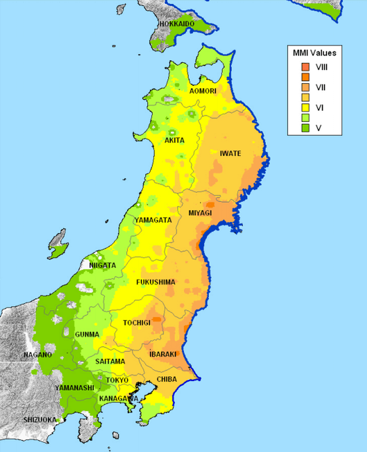
The locations with the highest inundation depths were typically associated with deep, funnel-shaped embayments that focused the tsunami waves. Figure 2 shows the ground shaking on the Modified Mercalli Intensity (MMI) scale and the coastal region impacted by tsunami inundation.
Figure 2: The impact zone for the 2011 earthquake and tsunami showing the ground shaking (red to green shading) felt across Honshu and the northeastern coastal areas affected by the tsunami (dark blue).
Using the shindo scale, also known as the Japan Meteorological Agency (JMA) Seismic Intensity Scale, Kurihara City in Miyagi Prefecture had the highest possible intensity of JMA7. Twenty-eight cities and towns in Miyagi, Fukushima, Ibaraki, and Tochigi Prefectures experienced JMA6+ intensity, causing significant damage over a large area.
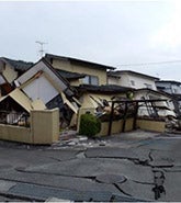
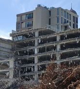
The impacts of the 2011 Great East Japan Earthquake and Tsunami were driven by three mechanisms: strong ground shaking from the M9.0 earthquake, extensive tsunami inundation, and a significant nuclear accident at the Fukushima Daiichi power plant, triggered by the tsunami waves. Communities across the Tohoku region suffered extensive damage from the earthquake ground motions and tsunami inundations.
Very detailed building damage statistics tabulated by the government show that more than 122,000 buildings were destroyed, 283,000 buildings were very significantly damaged, and more than 740,000 buildings were partially damaged. Not surprisingly, there was also extensive damage to infrastructure and lifelines. There were almost 4,200 sites of road damage, 116 bridges damaged, and 29 locations of railway damage.
Ultimately, this event caused the highest economic losses from a natural disaster ever observed: The World Bank estimated the economic impact at up to US$235 billion. For the local and international insurance and reinsurance communities, the earthquake and tsunami reflected the very significant insurance loss at an estimated cost of US$35 billion, making it the largest earthquake insurance loss in history.
This event provided the opportunity to fundamentally improve the scientific and engineering communities’ understanding of megathrust earthquakes and their impacts. The extensive ground motion observations across the dense network of seismic stations allowed for a comprehensive analysis of ground motion attenuation and frequency content, site amplifications, and basin characteristics.
The comprehensive damage statistics linked with ground motion observations and with tsunami inundation depths also provided invaluable data points for the calibration of building vulnerability functions. Because major earthquake disasters are so infrequent, utilizing the data to improve our representation of seismic risk is critically important. The RMS® Japan Earthquake and Tsunami HD Model is founded on the research and observation data stemming from the 2011 earthquake and tsunami. Our view of seismic risk for Japan has been fundamentally improved by these learnings.
Looking back 10 years, we must not lose sight that this event was a humanitarian disaster with almost 20,000 lives lost. People around the world depend on us, so we must keep challenging ourselves to improve our understanding of seismic hazard and risk. This will allow us to better plan and implement disaster mitigation to minimize lives lost.
Future events will help us continue to improve our understanding of megathrust earthquakes. In turn, we can mitigate risk more accurately in Japan and other vulnerable places in the world – and play our part in building a more earthquake-resilient society.
Chesley manages the commercial development of the Moody's RMS earthquake and tsunami models for the Asia-Pacific region. Chesley joined the Model Development Group at RMS in 1995, with expertise in developing seismic source models.
Through her tenure at Moody's RMS, Chesley was a model developer for key products including the 2018 Moody's RMS Japan Earthquake and Tsunami HD model and earthquake models for Europe, Asia, and Latin America. Chesley has recently shifted roles from model development to product management to use her years of experience at Moody's RMS to facilitate strategic product development, product marketing, and product management.
Chesley holds a master's degree in geophysics from Stanford University, where she researched ground deformation associated with the 1989 Loma Prieta earthquake.