Japan and more specifically Tokyo lie at the intersection where the Pacific and Philippine Sea tectonic plates are pushed under Eurasia. It is not surprising then that megathrust earthquakes along these tectonic plate boundaries drive the seismic risk in this region with their large magnitudes and relatively short return periods. It is important to understand that the story of seismic risk does not end there. In Japan, like many other places around the world where there are major subduction zones, a component of the convergence across the tectonic plate boundaries is accommodated on crustal faults.
In fact, the Japan islands are crisscrossed by crustal faults with several hundred of them delineated well enough to be included in the national seismic hazard maps. The two best known faults in Japan are the Itoigawa-Shizuoka Tectonic Line (ISTL) which cuts across Honshu north to south just west of Tokyo and the Median Tectonic Line (MTL) which is an east-west trending strike-slip fault that parallels the Nankai Trough from the Kii Peninsula into the heart of Kyushu. The 1995 M6.9 Kobe Earthquake occurred on a crustal fault, the Rokko-Awaji Shima Fault Zone, which branches off the MTL to the south.
Low-Frequency, but High-Consequence Events
The Kobe event highlights the high consequence impacts of crustal faulting events on inland exposures in Japan. Japan has a long history of natural disasters. There have been damaging earthquakes along all of the major subduction zone boundaries with their strongest impacts on coastal communities both through strong ground shaking and tsunami wave generation. Additionally, Japan is regularly impacted by damaging typhoons. As a result, major exposure concentrations have developed inland in locations with access to protected harbors. It is these inland regions that are most susceptible to being impacted by crustal faulting events. Over the 10 years following the Kobe event, the Headquarters for Earthquake Research Promotion (HERP) carried out significant research on the hazard posed shallow crustal faults. This led to the inclusion of an extensive fault database in the first set of national seismic hazard maps for Japan released in 2005.
When compared to subduction zone events, crustal fault earthquakes are generally smaller and have longer recurrence intervals often greater than 1000 years. When these events strike major exposure concentrations, they can result in very high losses. This characteristic of crustal events was again highlighted in 2016 with the Kumamoto earthquake sequence. These events happened at the western end of the MTL where the fault system rotates to the south and produces a wide zone of elevated seismicity.
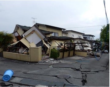
The Kumamoto events were the most damaging events to hit Japan since the 2011 M9.0 Tohoku Earthquake. This series of earthquake include several events over M5.5 with the largest at M7.0. Kumamoto Prefecture was severely affected with over 50,000 buildings damaged, of which more than 2,400 totally collapsed (see Figure 1). Damage occurred as a result of ground shaking, landslides, liquefaction, surface fault rupture, and fire-following earthquake, highlighting the importance of a comprehensive view of all sources of losses for the assessment of risk.
Figure 1. Residential single-family dwelling damage in Mashiki-machi, Kumamoto Prefecture. Source: RMS Reconnaissance Team
Crustal Fault Seismic Risk
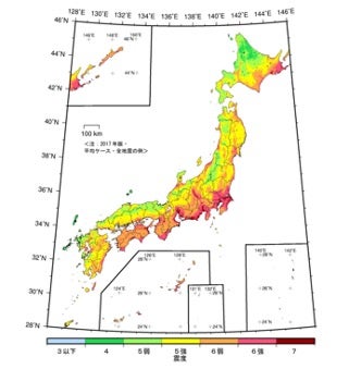
Following the 2011 Tohoku Earthquake and Tsunami, several extensive research projects were undertaken across Japan to understand the timing of past events and the potential for future events, including ones larger than those observed historically. While the bulk of this research was focused on studying the major subduction zones, there were initiatives assessing crustal faults. In the latest version of the seismic hazard maps for Japan the impacts of the crustal faults are clear (see Figure 2). Contributions from both the ISLT and the MTL can be seen in the maps by the increased the seismic hazard north of the Izu Peninsula and along the inland sea and northern coast of Shikoku.
Figure 2. National Seismic Hazard Maps for Japan showing 3% Exceedance Intensity (JMA) in 30 years. Source: Headquarters for Earthquake Research Promotion
The RMS Japan Earthquake and Tsunami HD Model implementation of seismic hazard follows the research behind the HERP national seismic hazard maps. There are, however, some important differences in modeling assumptions to account for some earthquake sources based on different interpretation of historical records, or additional sources of data that were not considered in National Hazard Maps. For the subduction zone, RMS use a comprehensive approach to recurrence modeling that accounts for all sources of event observations to produce a unique, robust solution. For crustal faults, RMS research focused on the fault locations and timing of events. Using a detailed fault atlas, RMS created a comprehensive fault database that captures very detailed fault traces and fault interactions and thereby provides a high-resolution view of the crustal fault hazards. The time-dependent recurrence for fault events is limited to sources with detailed chronologies of past events, with an emphasis on capturing hazard in the near term to reflect the current risk.
RMS Japan Earthquake and Tsunami HD Model: A Comprehensive Solution
Post-Tohoku research drove scientific advances in earthquake hazard modeling. RMS collaborated with local experts, scientific agencies, and insurers to develop a superior representation of earthquake risk in Japan. Leveraging substantial detailed damage statistics and claims data from the Tohoku and Kumamoto events, the model assesses building performance due to ground shaking, tsunami inundation, fire following earthquake, liquefaction, and landslides. The inclusion of these five sources of potential property damage and business interruption losses provides a comprehensive solution for managing and differentiating the risk posed by earthquakes in Japan.
Share:
You May Also Like
April 11, 2024
The Importance of Capturing the Contribution of Earthquake Catastrophe Risk in the Caribbean
Chesley manages the commercial development of the Moody's RMS earthquake and tsunami models for the Asia-Pacific region. Chesley joined the Model Development Group at RMS in 1995, with expertise in developing seismic source models.
Through her tenure at Moody's RMS, Chesley was a model developer for key products including the 2018 Moody's RMS Japan Earthquake and Tsunami HD model and earthquake models for Europe, Asia, and Latin America. Chesley has recently shifted roles from model development to product management to use her years of experience at Moody's RMS to facilitate strategic product development, product marketing, and product management.
Chesley holds a master's degree in geophysics from Stanford University, where she researched ground deformation associated with the 1989 Loma Prieta earthquake.