Major Hurricane Michael Ravages Florida and the Southeast U.S.
James CosgroveOctober 11, 2018
After the flood-driven impacts of Category 1 Hurricane Florence just under a month ago, yesterday’s unfolding drama from Major Hurricane Michael was dominated by damaging winds that were within touching distance of a Category 5 storm.
Major Hurricane Michael made landfall near Mexico Beach, Florida, at 17:15 UTC (12:15 CST) on Wednesday, October 10, as a Category 4 major hurricane — the first Category 4 or stronger hurricane to make landfall in the Florida Panhandle on record. At landfall, its maximum sustained wind speed was 155 miles per hour (250 kilometers per hour), just two miles per hour short of Category 5 classification.
Michael’s intensity at landfall has set numerous records. It becomes the strongest hurricane (by wind speed) to make landfall in the continental U.S. since Andrew in 1992 and the strongest (by wind speed) October landfilling hurricane in the continental U.S. on record. Its minimum central pressure of 919 millibars makes it the most intense hurricane (by minimum central pressure) to make landfall in the U.S. since Camille in 1969.
Michael had undergone rapid intensification of 35 knots and 46 millibars in the 24 hours up to landfall, benefiting from ideal development conditions — minimal wind shear and a warmer-than-usual Gulf of Mexico with sea surface temperatures one to two degrees Celsius above average. Its intensification was relentless right up to landfall and resulted in catastrophic damage in portions of coastline along Florida Panhandle.
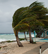
Prior to landfall, more than half a million people were under evacuation orders, and more than 20 million people in five states were under either a hurricane or tropical storm warnings.
Mexico Beach and Panama City Take a Full Hit
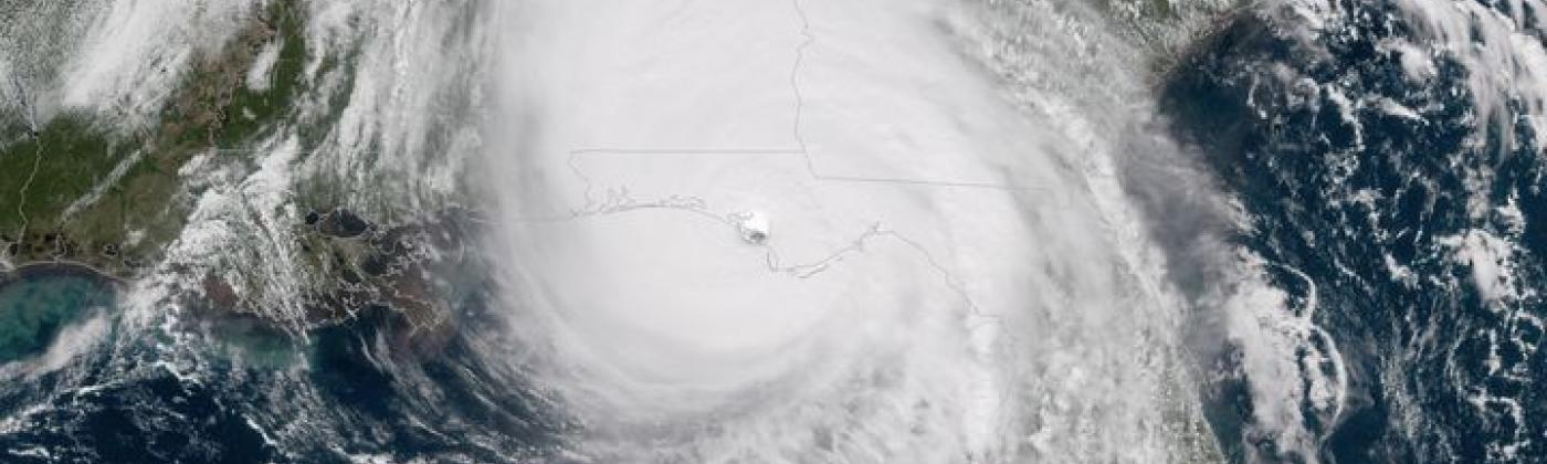
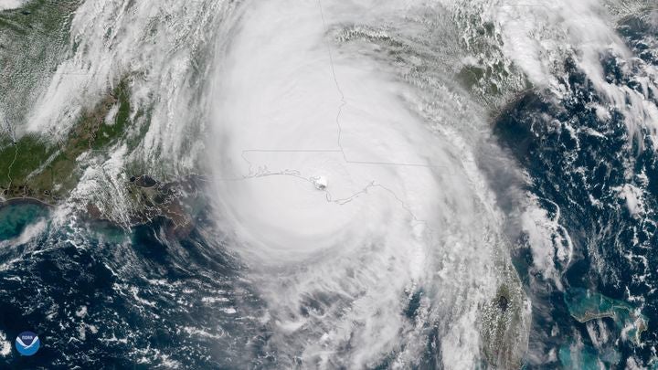
GOES East satellite imagery shows Hurricane Michael just as the storm made landfall at 1:30 p.m. ET October 10, 2018: Image credit: NOAA Environmental Visualization Laboratory
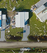
Mexico Beach (pop. ~ 1,072), the Tyndall Air Force Base, and Panama City (pop. ~37,000), were at the frontline of the landfall. A journalist for the Tampa Bay Times ventured to Mexico Beach in the dark early Thursday and found the town almost impassable, with many destroyed homes, “…some with staircases leading to doors suspended 10 feet (3 meters) in the air with nothing on the other side”, and entire structures washed away. The Washington Post reports FEMA Administrator William Long stating that “…search and rescue is where we are hyper-focused this morning” — particularly in Mexico Beach, which he said was “was wiped out” by Hurricane Michael’s storm surge.
In Panama City, images show severe damage to roofs, windows, sidings, and some buildings totally destroyed, with media reports from residents stating that there was “lots of damage to every building” in the city. According to CNN, Congressman Neal Dunn, whose district includes Panama City, said “it looks like a bomb went off on every single block.”
Just thirty miles northeast of Mexico Beach, social media reports show many trees fallen, and houses damaged by trees in Tallahassee (pop. ~181,000), with one fatality in Greenboro; a small town four miles west of the city, where a man was killed after a tree fell on his house.
Across Florida’s Panhandle, damaged roofs, downed power lines, debris and felled trees are widespread. Florida Highway Patrol closed an 80-mile stretch of the east-west Interstate 10 to clear debris, and the U.S. Army Corps are being positioned in the Florida Panhandle to cover “tens of thousands of damaged roofs.”
Leaving Florida, Michael tracked into Georgia as a Category 3 major hurricane with maximum sustained wind speeds of 125 miles per hour (200 kilometers per hour); remarkably this makes Michael the first Category 3 hurricane in Georgia on record. Around Albany, Georgia, there are media reports of broken windows, felled trees and roofs being blown away. In Augusta, Georgia, close to the South Carolina border, the NHC reported at 05:00 local time Thursday, sustained wind speeds at 50 miles per hour, still at tropical storm strength. A second fatality was confirmed by Georgia emergency officials in Seminole County, when a child was killed as a tree fell on a home during the storm. More than 850,000 customers are without power in in Alabama, Georgia, and Florida.
As of 12:00 UTC, the NHC confirmed that Michael was 40 miles (65 kilometers) west-northwest of Columbia, South Carolina, still with sustained winds at 50 miles per hour, and moving fast at 21 miles per hour towards the northeast. Strong winds, potential storm surge, localized flash floods and rainfall with total rain accumulations of four to seven inches is expected from eastern Georgia to the southern Mid-Atlantic states. Many of these areas are still recovering from the impacts of Hurricane Florence last month. Michael is forecast to maintain tropical storm strength even after it re-enters the Atlantic near Norfolk, Virginia early Friday morning.
At this very early stage with the event still in progress, it will obviously take time for the full picture to emerge, but as always RMS will continue to provide clients with Event Response services via RMS OWL, and please follow RMS on Twitter, LinkedIn, Facebook and visit the RMS blog for updates.
Share:
You May Also Like
May 01, 2024
2024 North Atlantic Hurricane Season: Early Forecasts Call for Active Season
Based in London, James is an Assistant Director within Moody's RMS Event Response team, supporting real-time event response operations and assisting on various event response projects. James holds a bachelor’s degree in Physical Geography and Geology from the University of Southampton and a master’s degree in Applied Meteorology from the University of Reading.