El Niño in 2015: Record-setting Conditions Anticipated, With a Grain of Salt Water?
Jeff WatersJune 01, 2015
Today the insurance industry gears up for the start of another hurricane season in the Atlantic Basin. Similar to 2014, most forecasting agencies predict that 2015 will yield at- or below-average hurricane activity, due largely in part to the anticipated development of a strong El Niño phase of the El Niño Southern Oscillation (ENSO).
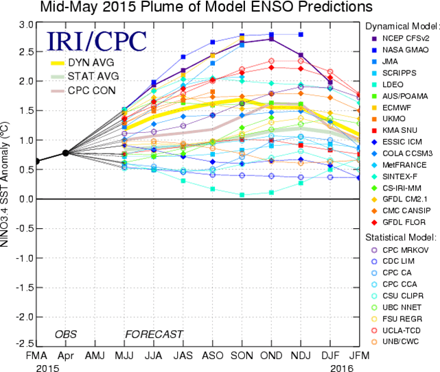
Unlike 2014, which failed to see the El Niño signal that many models projected, scientists are more confident that this year’s ENSO forecast will not only verify, but could also be the strongest since 1997.
Earlier this month, the National Oceanic and Atmospheric Administration (NOAA) Climate Prediction Center (CPC) reported weak to moderate El Niño conditions in the equatorial Pacific, signified by above-average sea surface temperatures both at and below the surface, as well as enhanced thunderstorm activity.
According to the CPC and the International Research Institute for Climate and Society, nearly all forecasting models predict El Niño conditions—tropical sea surface temperatures at least 0.5°C warmer than average—to persist and strengthen throughout 2015. In fact, the CPC estimates that there is approximately a 90% chance that El Niño will continue through the summer, and better than a 80% chance it will persist though calendar year 2015.
Model forecasts for El Niño/La Niña conditions in 2015. El Niño conditions occur when sea surface temperatures in the equatorial central Pacific are 0.5°C warmer than average. Source (IRI)
Not only is the confidence high for the tropical Pacific to reach El Niño levels in the coming months, several forecasting models predict possible record-setting El Niño conditions this fall. Since 1950, the record three-month ENSO value is 2.4°C, which occurred in October-December 1997.
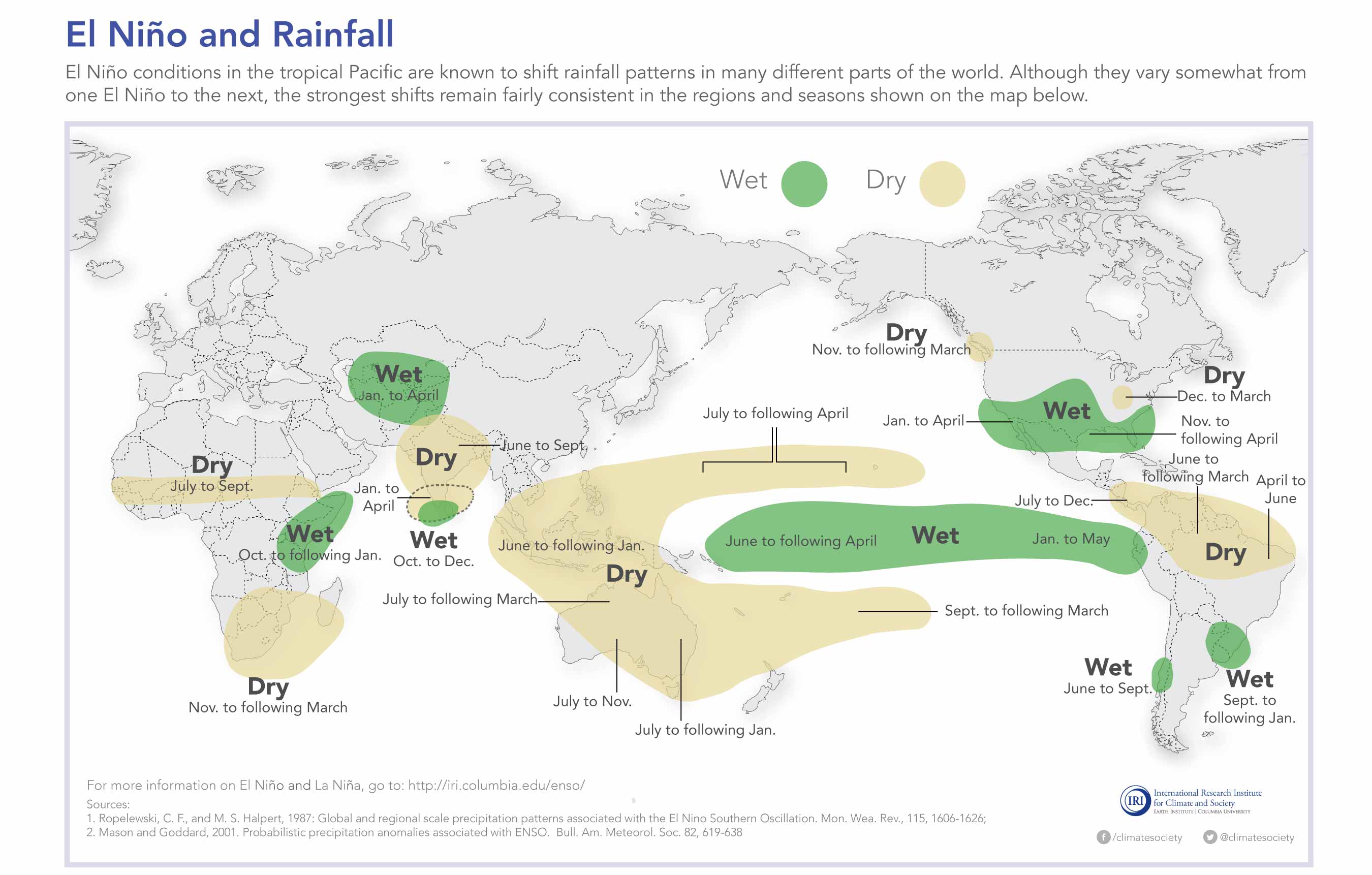
Impacts of El Niño conditions on global rainfall patterns. Source (IRI)
In the Atlantic Basin, El Niño conditions tend to increase wind speeds throughout the upper levels of the atmosphere, which inhibit tropical cyclones from forming and maintaining a favorable structure for strengthening. It can also shift rainfall patterns, bringing wetter-than-average conditions to the Southern U.S., and drier-than-average conditions to parts of South America, Southeast Asia, and Australia.
Despite the high probability of occurrence, it’s worth noting that there is considerable uncertainty with modeling and forecasting ENSO. First, not all is understood about ENSO. The scientific community is still actively researching its trigger mechanisms, behavior, and frequencies. Second, there is limited historical and observational data with which to test and validate theories, hence the source of ongoing discussion amongst scientists. Lastly, even with ongoing model improvements, it remains a challenge for climate models to accurately capture the complex interactions of the ocean and atmosphere, leading to small initial errors that can amplify quickly in the long term.
Regardless of what materializes with El Niño in 2015, it is worth monitoring because its teleconnections could impact you.
Share:
You May Also Like
September 27, 2023
Moody’s RMS North Atlantic Hurricane Models: Five Reasons Why Version 23 is the Right Model to Navigate a Challenging Market
Staff Product Manager, Model Product Management, Moody's RMS
Jeff Waters joined Moody's RMS in 2011 and is based in Bethlehem, PA. As part of the Product Management team, he is responsible for product management of the Moody's RMS North Atlantic Hurricane Models.
Jeff provides technical expertise and support regarding catastrophe model solutions and their applications throughout the (re)insurance industry. He also generates product requirements for future updates and releases, and helps develop the overall product strategy, messaging, thought leadership, and collateral to ensure its commercial and technical success.
Waters’ background is meteorology and atmospheric science with a focus in tropical meteorology and climatology. Jeff holds a B.S. in Geography/Meteorology from Ohio University (’09), and a M.S. in Meteorology from Penn State University (’11). He is a member of the American Meteorological Society, the International Society of Catastrophe Managers, and the U.S. Reinsurance Under 40s Group, Inc


