Christmas Day Cyclone – Lessons Learned 40 Years After Tracy
Margaret JosephDecember 23, 2014
December 25, 2014 marks 40 years since Cyclone Tracy made landfall early Christmas Day over the coast of Australia, devastating the Northern Territory city of Darwin. As the landfall anniversary approaches, we remember one of the most destructive storms to impact Australia and are reminded of the time when “Santa Never Made it into Darwin.”
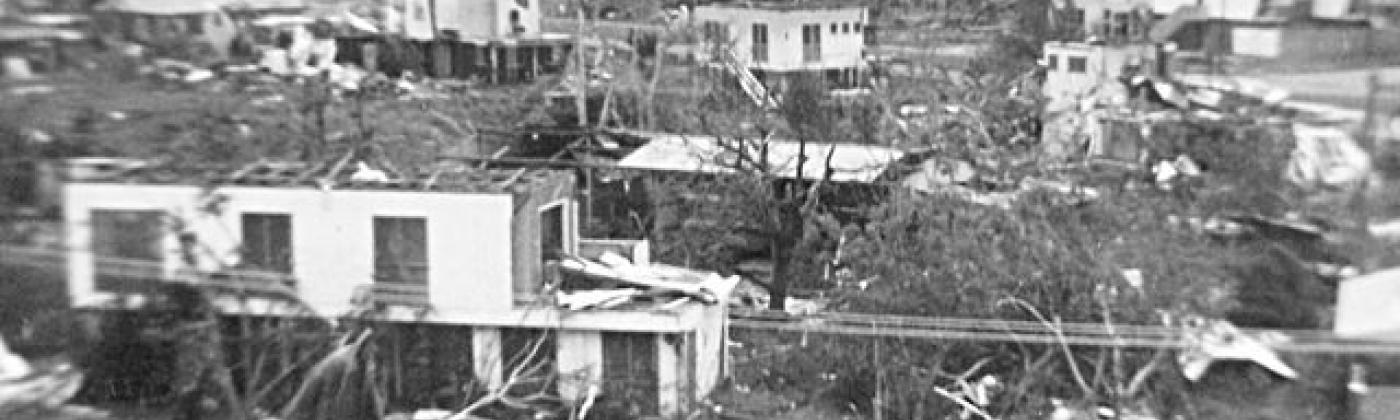
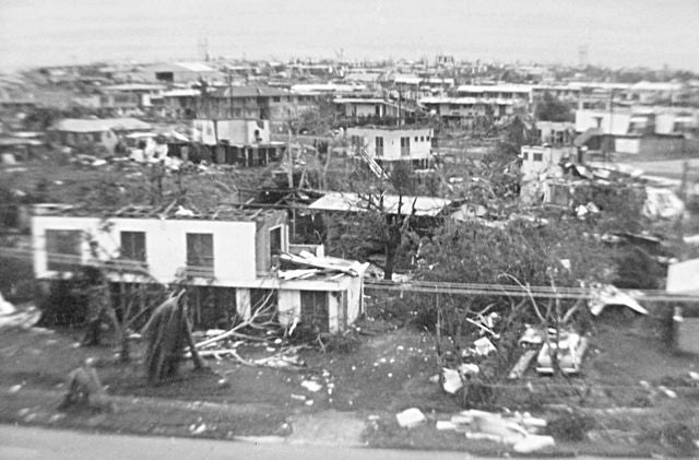
Small and intense, Tracy’s recorded winds reached 217 km/hr (134 mph), a strong category 3 on the 5-point Australian Bureau of Meteorology scale, before the anemometer at Darwin city airport failed at 3:10 am, a full 50 minutes before the storm’s eye passed overhead. Satellite and damage observations suggest that Tracy’s gust winds may have topped 250 km/hr (155 mph) and the storm’s strength is generally described as a category 4. At the time, it was the smallest tropical cyclone ever recorded in either hemisphere, with gale force winds at 125 km/hr (77 mph) extending just 50 km (31 mi) from the center and an eye only about 12 km (7.5 mi) wide when it passed over Darwin. (Tracy remained the smallest tropical cyclone until 2008 when Tropical Storm Marco recorded gale force winds that extended out to only 19km (12 mi) over the northwestern Caribbean).
Although small, Cyclone Tracy passed directly over Darwin and did so while tracking very slowly—causing immense devastation, primarily wind damage and predominantly residential structural damage. Around 60 percent of the residential property was destroyed and more than 30 percent was severely damaged. Only 6 percent of Darwin’s residential property survived with anything less than minor damage. Darwin had expanded rapidly since the 1950s, but throughout that time structural engineering design codes were typically not applied to residential structures.
The insurance payout for Tracy was, at the time, the largest in Australian history at 200 million (1974) Australian dollars (AUD), normalized to 4 billion (2011) AUD, according to the Insurance Council of Australia. It has been surpassed only by the payout from the 1999 Sydney Hailstorm at 4.3 billion (2011) AUD.
The RMS retrospective report that was released around the 30th anniversary of the storm provides information on the meteorology of the cyclone and the wind damage. The report also highlights the impact on wind engineering building codes (particularly residential) that were introduced as a result of the cyclone during reconstruction in Darwin and in cyclone affected regions of Australia—resulting in some of the most stringent building codes in cyclone-exposed areas across the world.
Darwin was completely rebuilt to very high standards and relatively new, structurally sound buildings now dominate the landscape. Most certainly, Darwin is better prepared for when the next cyclone strikes. However, the building stock in other cyclone-exposed cities of Australia is mixed. Most coastal cities are a blend of old, weak buildings and newer, stronger buildings, which are expected to perform far better under cyclone wind loading. The benefits of improvements in both design code specifications and design code enforcement have been demonstrated in Queensland by Cyclones Larry (2006) and Yasi (2011). Most of the damage to residential buildings in those storms was suffered by houses constructed before 1980, while those built to modern codes, incorporating the lessons learned from Cyclone Tracy, suffered far less damage. While progress has clearly been made, it is sobering to remember there are many more pre-1980 houses remaining in cyclone-prone areas of Australia.
Australia Cyclone season runs from November to April. The 2014/2015 season is forecast to be an average to below average season in terms of tropical cyclone activity off Australia waters, according to the Australian Government Bureau of Meteorology .
Michael Drayton contributed to this post. Michael Drayton has been developing catastrophe models for RMS since 1996. While based in London, he worked on the first RMS European winter storm model and U.K. storm surge models, lead the development of the first RMS basin-wide Atlantic hurricane track model, and oversaw the hazard development work on the first RMS U.K. river flood model. Since moving back to New Zealand in 2004, Michael has updated the RMS Australia cyclone hazard model and led the development of the RMS Australia (Sydney) severe convective storm model. He works on U.K. storm surge updates and supports U.S. hurricane model activities including audits by the Florida Commission on Hurricane Loss Projection Methodology. Ever since the 2011 Christchurch earthquake, Michael has been increasingly involved with the local insurance market and research communities. He received a BS degree in civil engineering, with honors, from the University of Canterbury and a PhD in applied mathematics from King’s College, Cambridge.
Share:
You May Also Like
August 14, 2020
New Insights Within the Japan Typhoon and Flood HD Model
As a member of the Model Product Management team at RMS Margaret works on our tropical cyclone models for the Asia-Pacific region, most recently and predominantly our latest Japan Typhoon Model. At RMS she has worked in the Catastrophe Response team for significant global natural catastrophe events through 2010 to 2013. Margaret holds a MSc in Remote Sensing from University College London and a BSc in Physical Geography from the University of Southampton. Margaret is a member of the Royal Meteorological Society, a member of the (U.K.) Remote Sensing and Photogrammetry Society, a fellow of the Royal Geographical Society, and through the latter is a Chartered Geographer.


