Within four weeks during late summer 2023, two severe rainfall events thousands of miles apart caused two pairs of dams to collapse, bringing catastrophic floods.
Both floods happened in the middle of the night, neither were forecasted, nor was there any evacuation plan. For many impacted locations, the wave of destruction arrived and departed faster than a tsunami.
For both events, in terms of lives lost and property damaged, the consequences were massively amplified by dam failures, and both are convincing manifestations of climate change.
Dams, it could be said, ‘weaponized’ the floods and turned high river flow into a catastrophic disaster. And as a consequence, climate change has just made a lot more assets uninsurable.
Libya
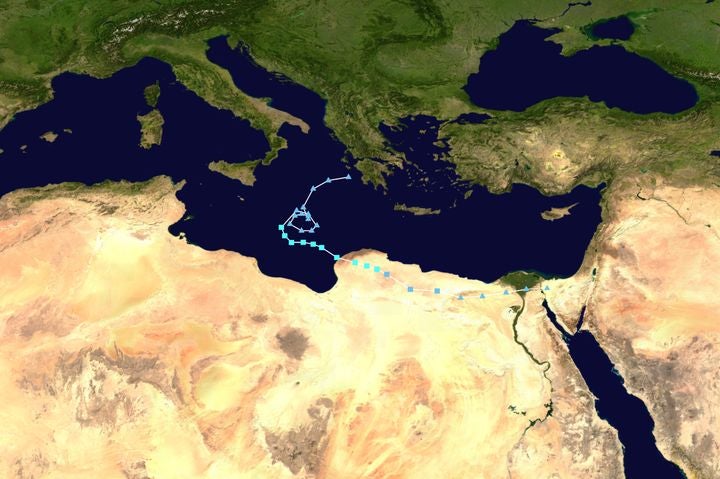
Between September 4-7, 2023, Storm Daniel, a deep low-pressure system in the eastern Mediterranean, brought intense rainfall over Greece and Bulgaria, setting a new daily rainfall record for Greece with a total of 760 millimeters (29.9 inches).
Moving over the warm waters of the south Ionian Sea, the storm then developed a hurricane-like circulation known as a ‘medicane’ (a Mediterranean hurricane).
Figure 1: Track map of Medicane Daniel of the 2022–23 European windstorm season. The points show the location of the storm at 6-hour intervals. Image from NASA; tracking data from UKMET.
On the night of September 9 and into September 10, the circulation stalled over the northeast Libyan coast, bringing winds of 70-80 kilometers per hour (43-49 miles per hour) and intense rainfall.
Rainfall measurement stations are few in Libya, but one rainfall reading of 250 millimeters (9.8 inches) was recorded in the coastal city of Derna, and 414 millimeters (16.3 inches) was recorded in the inland mountain city of Al Bayda.
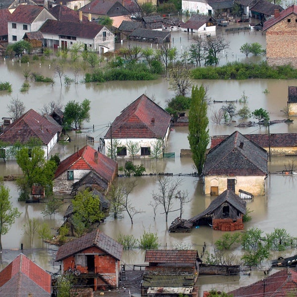
Several cities were flooded but only in Derna was this flooding truly catastrophic. Derna, with a population of around 90,000, lies at the mouth of the Wadi Derna which flows towards the east for 75 kilometers (46.6 miles) parallel with the coast along the back of the Jebel Akhdar mountains.
With a modest catchment of 575 square kilometers (357 square miles), for most of the year, the Wadi Derna riverbed is completely dry.
Al-Bilad and Abu Mansour Dams
After four floods in thirty years had inundated parts of the city of Derna, during the 1970s, the Libyan government commissioned Hidrotehnika-Hidroenergetika, a firm of Yugoslav engineers to build two clay-cored, earth embankment dams on the Wadi Derma.
The larger 70-meter-high (230 feet) Al-Bilad upper dam, just twelve kilometers (7.4 miles) inland, had a storage capacity of 22.5 million cubic meters (794.6 million cubic feet).
The second lower Abu Mansour dam had a storage capacity of 1.5 million cubic meters (53 million cubic feet) and was located just a kilometer (0.6 miles) from the river mouth on the edge of the city of Derna.
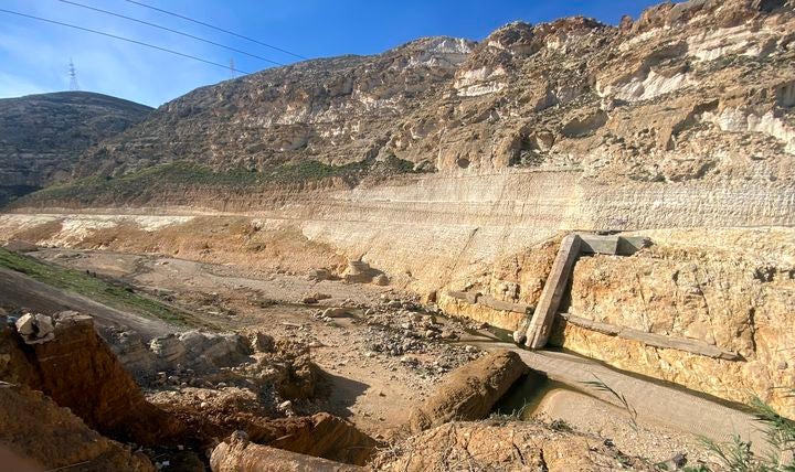
Figure 2: Abu Mansour dam after its collapse. Credit: Ahmed.khalil12410, CC BY 4.0 via Wikimedia Commons
The purpose of the dams, whether principally for water conservation or flood control, and the design specifications around extreme potential fluvial flows have been lost in the political turmoil of Libya, as this northeast region was under Islamic State control between 2014 and 2018. Since 2000 the dams have not been maintained.
We can only speculate what the rainfall was across the Wadi Derna catchment the night of September 9-10, but a rate of 100 millimeters (3.9 inches) in an hour would bring 50 million cubic meters (1.765 billion cubic feet) of water to the Al-Bilad dam, more than twice its storage capacity, while total rainfall was probably at least four times this amount.
We know that around 2.30 a.m. on September 10, the upstream Al-Bilad dam was overtopped and failed in a total breach, liberating downstream a vast 20 million cubic meter (706.3 million cubic feet) flood wave.
This rapidly overwhelmed and breached the second 45-meter-high Abu Mansour dam. Just before 3 a.m., a ‘fluvial tsunami’ arrived in Derna.
Impact on Derna
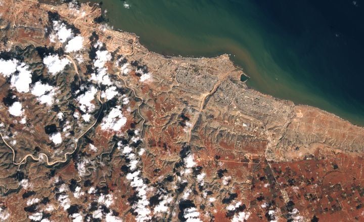
Figure 3: NASA Earth Observatory images by Lauren Dauphin, using Landsat data from the U.S. Geological Survey taken on September 18, 2023, showing the Wadi Derna and the city of Derna, with the eroded banks of Wadi Derna near where it meets the Mediterranean.
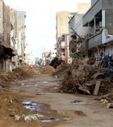
Given that the two dams had been holding back the initial flow, the flood in the city of Derna went from zero to maybe 100,000 cubic meters (3.53 million cubic feet) per second in under a minute. A flood wave was reported to have been 18 meters (59 feet) high beneath the lower dam, then reduced to 3-7 meters into the coastal plain.
The wave was powerful enough to remove all the concrete buildings along the flanks of the river channel, and those asleep in these buildings had no chance to escape.
Some 2,200 buildings in total were flooded and 870 were destroyed. The total number of fatalities is not known with many bodies washed out to sea, but is likely to be around 10,000 with another 40,000 displaced.
Climate Change Attribution
Attribution studies indicate that this rare rainfall event had been made three times more likely as a result of pre-existing warming, from a ‘1-in-1900 year’ event to a ‘1-in-643-year’ event, with daily extreme rainfall increasing by 29 percent.
However, the peak flood flow amplification caused by dam failure was then a much higher hazard multiple than that of the climate. This flow amplification was perhaps 10x to 20x the peak flow rate expected if there had been no dam. The dam failure concentrated or ‘weaponized’ the natural flows from this extreme precipitation event.
In terms of insurance loss, while no flood insurance was written in Libya, in other countries one might have expected litigation against the owners of the dams, whose neglect had caused the destructive flood wave. However, as these are state-owned, the survivors were dependent on government handouts.
Sikkim, India
The second pair of dam failures occurred at the southeastern end of the Himalayas situated between Nepal and Bhutan in Sikkim state, northeastern India. Again there were two dam failures involved, here one was natural, and a second man-made.
The natural dam failure was at the South Lhonak Lake in northwest Sikkim close to the border with Nepal and the frontier with China. This is as close as the Himalayas come to the Bay of Bengal and is an area of very high precipitation.
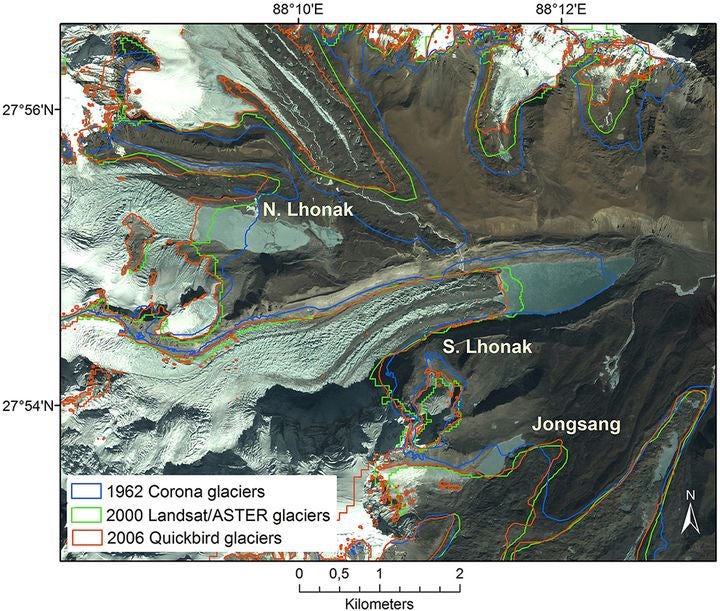
There are around 300 glacial lakes in northern Sikkim. As a result of climate change, the snowline has been rising over the past thirty years. The 5,200 meters (17,060 feet) elevation of the South Lhonak glacier has retreated rapidly, with the front of the glacier receding two kilometers between 1962 and 2008, while another 400 meters (1,312 feet) of retreat occurred up to 2019.
Figure 4: Satellite image from 2006 showing the expansion of the North and South Lhonak Lakes over four decades. Image Credit: A. E. Racoviteanu, Y. Arnaud, M. W. Williams, W. F. Manley - A. E. Racoviteanu et. al. Spatial patterns in glacier characteristics and area changes from 1962 to 2006 in the Kanchenjunga–Sikkim area, eastern Himalaya: The Cryosphere doi:10.5194/tc-9-505-2015, CC BY 3.0, https://commons.wikimedia.org/w/index.php?curid=85007347
A lake replaced the glacier, dammed by a steep and unconsolidated terminal moraine, and as the glacier retreated, the South Lhonak Lake expanded, from 42 hectares in 1990 to 135 hectares in 2019.
For the last twenty years, the lake had been identified as a potential site of a glacial lake outwash flood (or GLOF), one of ten sites in Sikkim. One 2013 study predicted there was a 42 percent probability of an outburst when 19 million cubic meters (671 million cubic feet) of water could be released, giving an extreme flow of 600 cubic meters (21,118 cubic feet) per second.
A 2016 study by the Government of Sikkim Department of Science and Technology called out the accelerated growth of the South Lhonak Lake, and a 2021 study published in the journal Geomorphology[1] estimated a peak discharge of 4,300 cubic meters per second in response to a 20-meter breach in the end moraine dam while peak flow could be 12,500 cubic meters per second for a 50-meter breach.
Most lakes with the potential to trigger GLOFs are in remote areas without large concentrations of downstream assets. However, the southern flank of the Himalayas is steep, and at lower elevations, valleys are highly populated.
Figure 5: Teesta River Basin showing rivers, dams, and hydroelectric projects. Source: www.sandrp.in
The South Lhonak Lake flows into the Lachen River which at 1,700 meters (5,577 feet) above sea level has a confluence with the Lachung River to form the Teesta River that runs on through the state of West Bengal and Bangladesh to join the mighty Brahmaputra River.
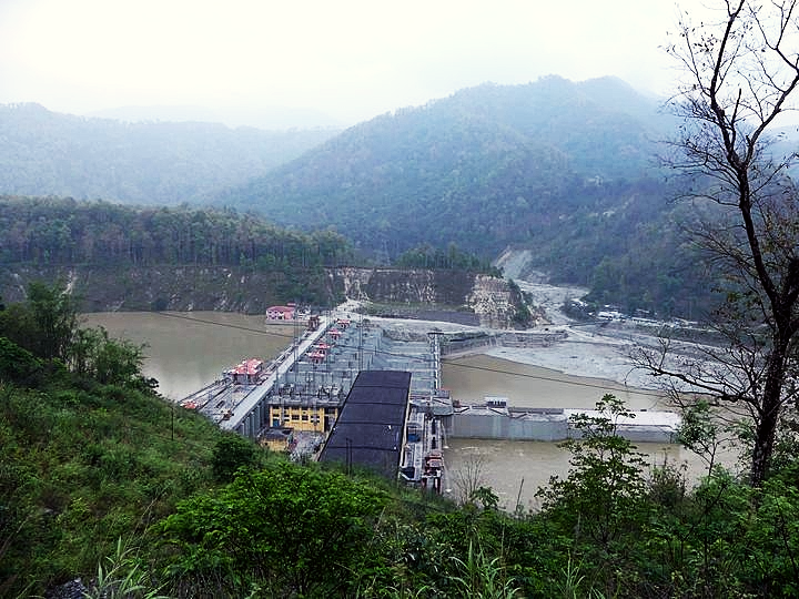
Four hundred meters below this confluence is one of the largest hydropower plants in the Himalayas (Teesta Stage III), constructed and opened in 2017. This was a ‘run of the river’ plant, with only a small reservoir of five million cubic meters.
The upper dam at Chungthang, a concrete-faced rock-filled embankment, was 300 meters wide and 60 meters high with three 3.8-meter diameter penstock tunnels giving a net head of 778 meters (2,552 feet) down to the six-unit 1200-megawatt Teesta Stage III power plant.
Figure 6: Lower Dam III across Teesta River before flooding. Credit: A. J. T. Johnsingh, WWF-India, and NCF, CC BY-SA 4.0 <https://creativecommons.org/licenses/by-sa/4.0>, via Wikimedia Commons
The hydropower plant operated by Sikkim Urja produced revenue for the Sikkim government, which had a 60 percent stake in the project. Almost all the power was exported to other Indian states, as Sikkim only consumed 100 megawatts. The project had cost 13,000 crore rupees or about US$1.55 billion.[2]
Concerned about the increasing potential for a GLOF, with 2023 rainfall in northern Sikkim 50 percent higher than usual, on September 16, the Indian Disaster Management Agency installed a solar-powered twin-camera automated weather station at South Lhonak Lake (along with a second station at another glacial lake).
After three days the weather station at South Lhonak stopped transmitting. Two weeks passed until around 10 p.m. on the evening of October 4, after hours of intense ‘cloudburst’ rainfall, the terminal moraine dam at South Lhonak Lake failed, sending a 19 meter (62 feet) high flood wave down the valley of the Lachen Chu.
AnIndo-Tibetan border force soldier first reported the flood wave at 10.30p.m. and within twenty minutes the news was relayed to staff at the Chungthang dam.
The flood wave took an hour to travel 60 kilometers (37.2 miles), losing 3,500 meters in elevation from the lake to the dam. The reservoir of the Chungthang dam was full and while staff at the dam attempted to open the spillway gates it was too late. As the flood water inundated their operations, they had to abandon their location.
The dam had been designed for a maximum flow of a little over 8,000 cubic meters a second, calculated from estimating extreme monsoon rainfalls, but that required a fully open spillway. The dam might have survived the flood wave from the burst glacial lake if hours of warning had been given so that the reservoir at the dam could be emptied.
However, the reservoir was close to full capacity and the flood wave passed over the whole dam, including sections not intended for overspill, causing the facing to breach adjacent to the spillway.
Within ten minutes there was complete erosive failure of the dam so that all the water in the dam’s reservoir now supplemented the original flood wave. The Teesta III turbine hall was completely inundated.
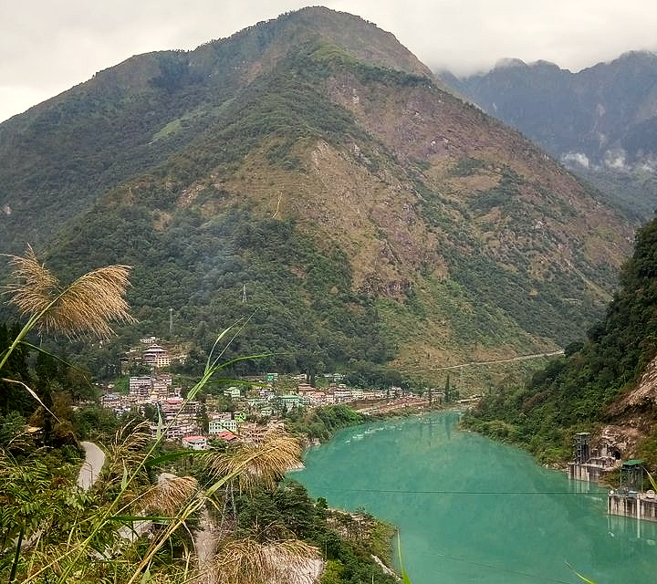
Figure 7: Chungthang town before the flooding. Credit: Pratap Chakma - Wikimedia Commons
The dam failure added five million cubic meters to the original glacial lake flood which may have been 10-20 million cubic meters. The combined flood wave brought catastrophic damage to Chungthang town (pop. ~4,000) at an elevation of 1,700 meters (5,600 feet), with 80 percent of buildings destroyed.
Warnings were now sent to towns further downstream, and sirens and loudspeakers alerted the population to move away from the river. Yet there was no evacuation plan, and 23 soldiers were swept away from their barracks at Bardang when the flood wave arrived 90 minutes after the original outburst.
Water levels downstream rose 5-6 meters (one report states 15-20 meters) swept away 14 bridges, damaged 1,825 houses, claimed at least 94 lives (with 78 missing), and forced 2,563 displaced people into 21 relief camps.
The power station and bridge of the 510-megawatt Teesta V hydro plant further down the river was also extensively damaged. The low-lying parts of some riverside towns, such as Singtam (pop. ~6,000) and Rangpo (pop. ~10,500) were left buried under five meters of sand. Even at the border of Sikkim with West Bengal at Melli, the flood took out sections of the national highway.
The dam and hydroelectric plant were insured to a value of 11,400 crore rupees (US$1.4 billion). However, reinsurers had inserted a clause into their contracts reducing coverage to only 500 crore rupees (US$60 million) if the damage had been caused by a GSOF.
Satellite images confirmed the GSOF: showing the lake covered 170 hectares in late September 2023 but only 60 hectares the day after the outburst.
In November 2023 Sikkim Urja filed an insurance claim for 500 crore rupees, while insurers announced that, based on reinsurance costs, the price of insurance for Indian public assets would increase by 25 percent. There was also talk of establishing a hydro dam pool.
Many important lessons emerge from the 2023 flood catastrophes both in Libya and Sikkim, India. First, both events can be identified as examples of climate change.
The exceptional, even unprecedented, rainfalls in northern Libya were a consequence of warmed sea-surface temperatures after a record hot summer.
In Sikkim, the switch from a glacier to a glacial lake at South Lhonak since 1990 was a clear consequence of warming. The collapse of the moraine dam was itself a result of intense rainfall.
However, the event is also having other negative consequences around climate change adaptation and mitigation.
As a result of the Sikkim flood, reinsurers are reducing their coverages claiming that ‘…climate change risks are too significant for conventional covers.’ This is likely to mean limited capacity for hydropower projects in the Himalayas and communities downstream from dams.
The loss of 1,200 megawatts of sustainable electricity production will now raise emissions from coal-burning plants in India. However, while climate change may have been a driver, these events became catastrophes as a result of human action.
What happened in both Libya and Sikkim teaches some serious lessons about dam design and risk. It is not good enough to simply achieve some threshold, such as withstanding a 1-in-100 or 1-in-500-year flood if more extreme events lead to catastrophic outcomes.
First, these probabilities are shifting in a warming world with higher rainfalls and new glacial lakes.
Second, one needs to explore risk far beyond these return periods, or annual probabilities, to discover whether dire outcomes are lurking, like a flood that kills 10,000 or a US$1.5 billion hydropower plant loss.
For every dam, this requires exploring deep into the risk curve, at least as far as the 0.1 percent annual probability, to see whether annual expected fatalities or damages are higher with or without the dam.
For Wadi Deira we could say with some confidence that annual life lost has been raised by a factor of ten or a hundred because a decision was taken to build a 70-meter clay-cored dam.
The Sikkim catastrophe should urgently draw attention to the fate of other communities living downstream of dams, unable to withstand the most extreme rainfalls, which have their failure potential exacerbated through warming.
Dams should be designed to withstand extreme overflow without failing, something that can be achieved with concrete dams, but as highlighted in Libya and Sikkim in 2023, this is more of a challenge with earth and rock embankment dams. This applies to mine tailings dams, dams built for water conservation or flood control.
Catastrophe models are required to determine the number of properties destroyed, or casualties resulting from exacerbated dam failure from which it then becomes possible to produce downstream risk-cost, or loss of life, exceedance probabilities.
The Indian Dam Safety Act of 2021 only concentrates on structural safety and not operational safety. A dam needs to be actively managed through a high flow crisis, employing multiple streams of real-time monitoring as well as operators available 24/7 to take action.
One problem with ‘run of the river’ plants is that they have little ability to create water storage by which to contain a flood wave. Inevitably therefore they are significantly riskier. While a flood wave from rainfall can be forecasted, a GLOF can arrive with very little warning.
The situation in Sikkim has invited scrutiny of similar hydropower plants under construction, or already built, in neighboring Bhutan. In 2009, India agreed to import a minimum of 10,000 megawatts of electricity from 13 Indian-financed projects with a total installed capacity of 12,241 megawatts.
With two extreme rainfall events both causing dam failures leading to catastrophic floods, the evidence is clear. Without urgent reviews of existing dams and building additional levels of resilience for new dam and hydropower projects, we can expect many dam failures in the future.
With ever more dams, with increased deterioration of older dams, all subject to more extreme river flows, we are in an era of exponential risk.
[1]A study titled Future Glacial Lake Outburst Flood (GLOF) Hazard of the South Lhonak Lake, Sikkim Himalaya published in the Geomorphology Journal in 2021 by Ashim Sattar et al.,
Access broad-scale, well-validated views of flood…
Learn More
Robert Muir-Wood
Chief Research Officer, Moody's RMS
Robert Muir-Wood works to enhance approaches to natural catastrophe modeling, identify models for new areas of risk, and explore expanded applications for catastrophe modeling. Robert has more than 25 years of experience developing probabilistic catastrophe models. He was lead author for the 2007 IPCC Fourth Assessment Report and 2011 IPCC Special Report on Extremes, and is Chair of the OECD panel on the Financial Consequences of Large Scale Catastrophes.
He is the author of seven books, most recently: ‘The Cure for Catastrophe: How we can Stop Manufacturing Natural Disasters’. He has also written numerous research papers and articles in scientific and industry publications as well as frequent blogs. He holds a degree in natural sciences and a PhD both from Cambridge University and is a Visiting Professor at the Institute for Risk and Disaster Reduction at University College London.