Situated at the meeting point of the Pacific and Indo-Australian tectonic plates, New Zealand is no stranger to seismic activity.
Over the past 15 years, the country’s relationship with earthquakes and their insurance repercussions has taken a transformative journey, influenced largely by three pivotal developments: significant seismic events, market alterations, and leaps in scientific understanding.
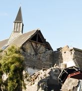
As the second-largest earthquake-insured loss worldwide, the 2010-11 Canterbury Earthquake Sequence (CES) still stands out as a grim reminder of the risk in New Zealand. The staggering insured loss of NZ$33-NZ$38 billion in 2011 values (US$19.6-US$22.5 billion) was a wake-up call for many.
The CES not only emphasized the potency of New Zealand’s seismic forces but also brought the country’s comprehensive insurance penetration to the forefront, together with the subsequent role of the world’s reinsurance market.
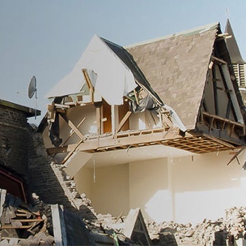
The spotlight was further intensified some five years later with the 2016 Kaikōura Earthquake, which unraveled a series of complex interlinking faults over an expanse of 180 kilometers (112 miles).
Given the region’s high seismic activity and insurance penetration, it is crucial that we continually update our models to provide the (re)insurance industry with the best possible tools.
The motivation for updating our New Zealand Earthquake HD Model to Version 3 was the recent release by GNS Science of the 2022 National Seismic Hazard Map, also known as GNS22.
The previous 2010 version, though comprehensive for its time, obviously lacked the insights that we gained from subsequent seismic events, especially the CES, in addition to methodological advances.
Implementing the GNS22 for Enhanced Risk Assessment
Our commitment to staying at the forefront of risk management and providing the most reliable modeling service to our clients drove us to be the first in the market to implement the new GNS22 Hazard Map.
With Moody’s RMS a member of the technical advisory committee for the GNS22, one of our lead developers contributed to enhancing our understanding and reinforcing our commitment to earthquake research and insurance in New Zealand.
The 2022 revision of the National Seismic Hazard Map estimates that the likelihood of future earthquake-shaking hazard has risen across most parts of the country, relative to the prior hazard map. In certain areas, the predicted likelihood from GNS Science has more than doubled, and on average, hazard results have surged by 50 percent.
Although GNS22’s updates are significant, it is worth noting that several of these insights were already integrated in 2016 for Version 1 of our New Zealand Earthquake HD Model.
As the prior HD model was forward-looking and incorporated science and innovations not included in the 2010 National Seismic Hazard Map, the hazard and consequent loss changes in Version 3 relative to Version 2 are considerably smaller than the hazard changes in GNS22.
A key update in the Version 3 model is new ground motion and site amplification models. These models are now based on the new ground motion and site amplification in GNS22, which are more complex and reflect the latest local and global ground motion models.
With the new models, we can more accurately calculate the ground motions for New Zealand. This is fundamental to understanding our client’s exposure to earthquake risk.
By integrating and implementing the insights from GNS22, we are ensuring our version 3 model is rooted in the latest scientific understanding, offering unparalleled risk assessments and solutions to our clients.
Enhancing Seismic Understanding
As we rigorously updated our model to align with the ground-breaking insights from the GNS22, we also seized the opportunity to further enhance our offering with targeted updates to the geotechnical and vulnerability components, including:
- Updated Soil Data: Christchurch is a city that has borne the brunt of the recent seismic activities in New Zealand and has subsequently found itself at the heart of much scientific research. For Version 3 the soil index has been updated for downtown Christchurch, reflecting recent ground improvement reports and observation data.
- Vulnerability: The 2016 Kaikōura Earthquake served as a case study, revealing the fragility of certain building structures, particularly hollow-core floor constructions. Extensive research following the event has informed us that post-2005 hollow-core floor buildings might be more vulnerable than initially thought. Consequently, our Version 3 model updates the vulnerability curves for these buildings.
- Post-event Loss Amplification (PLA): Considering the new modeled losses in Version 3, we have updated the PLA factors to help users understand the potential for loss amplification associated with large, damaging earthquakes.
Market Changes and EQC Policy Updates
Having comprehensively explored the GNS22 update and its implications for our understanding of New Zealand’s seismic hazards, it is equally important to highlight the changes in the earthquake insurance market.
In New Zealand, the Earthquake Commission – Toka Tü Ake EQC, a Crown entity, plays a pivotal role by offering earthquake insurance for residential properties nationwide. Their unwavering commitment to safeguarding New Zealand homeowners is reflected in the country boasting one of the highest earthquake insurance take-up rates globally.
The recent seismic activities have prompted the EQC to introspect and reassess their coverage terms. The most significant among these was the decision to double the building limit to NZ$300,000 (US$178,000).
These new coverage terms redistribute the earthquake risk with a considerable increase to Toka Tü Ake EQC’s responsibility compared to the private market.
These new policy terms are incorporated in our new Industry Exposure Data (IED) for the region, including recent inflation. Our Industry Loss Curves (ILC) are also updated to reflect this change in industry exposure alongside our model updates.
These enhancements ensure that our partners and clients can navigate these new changes with the most accurate and up-to-date data at their fingertips.
With the earth beneath New Zealand constantly evolving, the need to understand and adapt to its seismic complexities becomes a challenging yet vital task.
Our latest New Zealand Earthquake HD Model Version 3 reaffirms our commitment to providing the (re)insurance industry with state-of-the-art tools, ensuring that as the landscape shifts, our understanding and preparedness evolve in tandem.
Learn more about how Moody’s RMS New Zealand Earthquake HD Model Version 3 can help you better manage seismic risk.
Existing customers can also access the latest New Zealand Earthquake HD Model documentation from Moody’s RMS Support Center.