Michael Young, Head of Americas Climate Model Product Management, RMS
The story of Hurricane Maria, the thirteenth named storm of the 2017 North Atlantic hurricane season, really started with landfall over Dominica on Tuesday, September 19 — as a category 5 hurricane. It was then Puerto Rico’s turn. As Maria approached, the system did weaken slightly during an eyewall replacement cycle, and made landfall on Wednesday, September 20, near Yabucoa, as a category 4 hurricane. It was the most intense landfalling hurricane for the island since the 1928 San Felipe Segundo Hurricane, with RMS HWind reporting maximum sustained winds of 130 miles per hour (209 kilometers per hour).
Insured Loss Estimate Between US$15 to US$30 Billion
RMS estimates that the total insured loss from Hurricane Maria will be between US$15 billion and US$30 billion. Although islands such as Dominica sustained more intense damage, the overall industry loss estimate is dominated by the concentration of value on the island of Puerto Rico, representing over 85 percent of the losses from the event.
For the total economic loss from Maria, RMS estimates it will reach between US$30 billion and US$60 billion. Economic losses are defined as losses to all potentially insurable properties, independent of whether they have coverage or not. It does not include items such as roads and utilities, or government-owned property.
Insurance penetration rates in the Caribbean — defined as the ratio of insured value versus potentially insurable values, are far more variable than in the U.S. On average, the insurance penetration rate for Puerto Rico is about 60 percent.
In producing our loss estimates, RMS has incorporated many innovations and updates to assist with examination of the hazard, exposure, and vulnerability for an event, and it is worth looking at some of the challenges posed by this event and how these innovations have helped.
Assessing the Wind Hazard
One of the biggest challenges in modeling Maria’s wind field was the widespread failure of wind measuring stations across Puerto Rico, including the destruction of the island’s radar dome. By incorporating RMS HWind hurricane product data into our event reconstructions, RMS can supplement reconstructions with tens of thousands of wind observations from a network of over 30 land, sea, satellite, and airborne observational data sources.
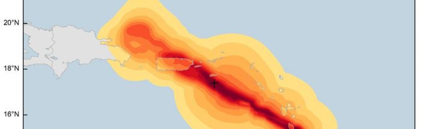
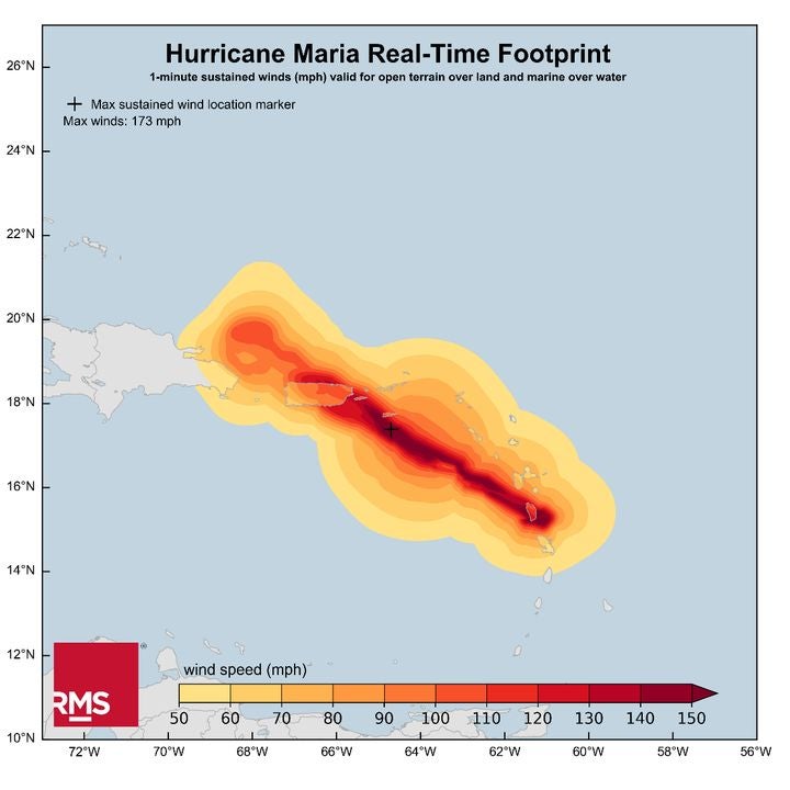
Figure 1: RMS HWind real-time footprint showing 1-minute sustained winds on September 21, 2017 06:00 UTC
Observations gathered from the RMS HWind network allowed for the calculation of key storm parameters that are integral to the accurate reconstruction a hurricane’s wind field directly —including radius to maximum winds — instead of relying on third-party estimates. The radius to maximum winds is a key parameter which impacts the area covered by the storm’s strongest winds.
By using RMS HWind to obtain this value, we know that the area covered by Maria’s strongest winds was close to the track and not across the majority of Puerto Rico, especially in areas of high insured exposure on the northern part of the island. Our reconstructed wind field can accurately represent this and the full gradient of winds experienced across the island. This allows for a more precise representation of observed wind speeds in high exposure areas, for more accurate damage calculations.
Latest View of Exposure
The RMS Industry Loss Estimate is based upon the 2017 Caribbean Industry Exposure Database, which represents the most up-to-date view of insured hurricane exposure in the region. This is developed using a bottom-up approach and is based on the Caribbean Economic Exposure Database (EED) for building exposure and values.
RMS estimates that there is approximately US$300 billion of insured exposure on Puerto Rico, of which 70 percent is related to residential exposures. Input data was used at several resolutions to ensure the most accurate representation of exposure, including building-level, postal code, parish, and county resolution. For validation, RMS used visual surveys of satellite images and aerial photographs to validate building size estimates, as well as on-the-ground field information. In 2015, a team of RMS engineers visited several Caribbean countries and territories to collect statistics to use in developing building size and replacement cost models.
Caribbean Vulnerability
For the Version 17 RMS North Atlantic Hurricane Models, the full suite of Caribbean vulnerability curves was recalibrated across all lines of business and coverages. This recalibration is in part based upon a three-week field visit to the Caribbean, including several days in Puerto Rico, by RMS modeling personnel in 2015. As a result, this estimate represents the most up-to-date view of vulnerability in Puerto Rico and other islands across the Caribbean.
It is well known that a significant proportion of industrial exposure on the island relates to pharmaceutical and life science manufacturing facilities, and RMS has detailed risk studies for some of these facilities on the island via past client projects. In this key sector, most industrial facilities on the island have robust disaster management plans in place and strong mitigation programs. Therefore, RMS expects losses to the industrial lines to be relatively minor even if subjected to category 5 strength wind speeds. My colleagues Peter Datin and Rajkiran Vojjala have written a separate RMS blog looking at the impact of Maria on industrial facilities in Puerto Rico.
RMS personnel also studied in detail the reinforced concrete, “bunker-style” construction prevalent across the island, particularly in low- and mid-rise single-family and multi-family dwellings. This construction style features flat, concrete slab roofs that resist hurricane-force winds well. Improved understanding of these “bunker-style” structures informed updates to Puerto Rico vulnerability curves in versions 13 and 17 of the RMS North Atlantic Hurricane Models.
Loss Escalation
Hurricane Maria did severely impact power and telecommunication systems on the island. The cumulative impact of Hurricanes Maria and Irma caused significant damage to several transmission and distribution lines in Puerto Rico and the U.S. Virgin Islands. For Puerto Rico, initial estimates suggest that over 80 percent of the power distribution network has been damaged — with power estimated to take approximately three to six months to be restored.
There are also potential amplifying effects on industry losses. Fuel for electricity generators is running short, and as well as being a humanitarian concern, this will have implications for Puerto Rico’s economy with significant business interruption — including to the island’s important pharmaceutical industry. Flooding has also washed away roads and bridges. These electricity shortages, significant infrastructure disruption, and possible labor shortages, are expected to amplify direct losses by almost 50 per cent, which is reflected in our estimate.
Combining the latest modeling innovations, up-to-date exposure and vulnerability data supported by on-the-ground presence and local knowledge helps us to provide clients with a clearer picture of post-event losses across the islands impacted by Maria. In turn, our observations from Maria will help us better understand events impacting the region in the future.
Share:
You May Also Like
March 16, 2022
U.S. Wildfire: Calculating the Value of Mitigation Benefits From Forest Treatment Strategies
Vice President, Model Product Management, Moody's RMS
Michael leads a team that establishes requirements and features for all of the Moody's RMS North and South America climate models. Michael's responsibilities include overseeing the submission of Moody's RMS products to regulatory reviewers, such as the Florida Commission on Hurricane Loss Projection Methodology (FCHLMP).
Michael has led studies of insurance mitigation programs for the state of Florida, as well as the World Bank. In his past 14 years at Moody's RMS, Michael has also worked as a lead wind vulnerability engineer, a director of claims and exposure development, and as the head of the mitigation practice. He has worked in commercial wind-tunnel laboratories doing studies on wind loads for a variety of buildings.
Before joining Moody's RMS, he was involved in the development of Federal Emergency Management Agency (FEMA) HAZUS-MH software for hurricane risk assessment, and he taught courses on the use of HAZUS hurricane and flood components. Michael has also led studies on mitigation cost effectiveness for building codes such as the 2001 Florida Building Code and the North Carolina Building Code.
Michael holds a bachelor's degree in Civil Engineering and a master's degree from the University of Western Ontario in Canada in Wind Engineering.