In 2001, the geophysicist Steven N Ward (from UC Santa Cruz) and the volcanologist Simon Day (University College, London) published a paper[1] entitled “Cumbre Vieja Volcano — Potential Collapse and Tsunami at La Palma, Canary Islands.” The paper modeled coastal heights of a regional North Atlantic tsunami that they believed could be triggered by a flank collapse from the island of La Palma in the Spanish Canary Islands. La Palma covers an area of 708 square kilometers (273.4 square miles) and is 482 kilometers (300 miles) west of the Moroccan coast.
The Cumbre Vieja volcano, now world-famous since an eruption started on September 19, comprises the southern third of the island of La Palma, with magma eruptions occurring close to the crest of the ridge. The southern part of the island rises to two kilometers above sea-level, with the neighboring oceanic sea floor at a depth of about four kilometers, so this is a steep sided, six-kilometer-high edifice.
The volcano currently has the highest rate of magma production of any of the Canary Island volcanoes – six magma outpourings since 1600, with the ongoing accumulation of load along the principal axis of the volcano. Volcanoes on Lanzarote and Tenerife have also seen eruptions within the last 300-350 years, and on several previous occasions giant landslides have slumped off the side of one or other among the Canary Islands. In the center of La Palma, the landscape is still dominated by the westerly facing scarp that was the headwall of the Cumbre Nuevo landslide around 566,000 years ago. Sooner or later another flank collapse seems inevitable.
Potential for New Landslides
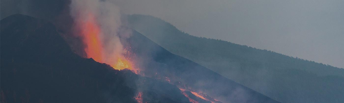
Since September 19, 2021, there has been an effusive magma eruption from an aligned set of craters on the Cumbre Vieja volcano to the northwest of the site of eruptions from 1949[2]. What does this mean for the potential for large landslides off the western flank of the island and for the tsunamis that such landslides could generate?
Ward and Day claimed the next landslide on the island would have a north-south headwall 15 kilometers long, as this is the length of the volcanic ridge that has been the site of eruptions dating back to the fifteenth century (along which the 2021 eruptions are towards the center). In 1949, a four-kilometer normal fault developed along the crest of the ridge at the site of the ongoing eruption, highlighting a “trial” landslide headwall. This fault has not shown evidence of further displacement since 1949.
Ward and Day also predicted the next landslide would have a volume between 150-500 cubic kilometers, with a headwall 2-3 kilometers east of the 1949 fault, while the landslide toe would be on the west side of the island, some 1-3 kilometers below sea-level.
Using linear wave theory, and in a scenario in which the landslide block maintains total coherence and moves downhill at up to 100 meters per second, they predicted:
- Sea waves reaching 400 to 600 meters high around the coasts of the three western Canary Islands
- Waves between 5-100 meters high hitting the coast of Africa
- 15-20-meter-high waves on the coast of South America
- Spain and England are partially protected by the island of La Palma itself, with waves reaching 5-7 meters
- Waves approaching Florida were modeled to reach heights of 20-25 meters.
These tsunami height estimates, unsurprisingly, have attracted a lot of popular and scientific attention. Many groups of scientists have revisited Ward and Day’s assumptions and tsunami models.
Would a Landslide Remain Intact?
A key question concerns whether such a landslide would stay as a single geological block as the landmass passes into the sea. Evidence from turbidites – sea-bottom deposits formed by massive slope failures, was sampled beneath the deep seafloor of the Madeira Abyssal Plain from eight Canary Island submarine slides over the last 1.5 million years, (one of which was from La Palma[3]).
Researchers found these flank collapses have typically comprised multiple smaller slides, generating distinctive turbidite “sub-units,” perhaps over a period of hours or days[4]. A 350 cubic kilometer block might be reduced to fragments in which the largest piece was around 100 cubic kilometers. While still producing devastating tsunamis in the neighboring coastlines of the Canary Islands, multiple smaller slides will have much reduced far-field tsunamis.
There are also questions as to what constitutes the most appropriate physics model for tsunami propagation[5]. Commonly used codes – such as the SAGE hydrocode, THETIS, or FUNWAVE-TD, that implement various physical solutions[6][7]all generated significantly lower tsunami heights along the east coast of North America than the Ward and Day output, typically in the range of 1-3 meters. But all models agree that the consequences on La Palma and the nearby Canary Islands would be devastating, especially for communities located on the actual landslide.
While employing more physically-realistic tsunami models reduces the tsunami heights in the far-field, no-one is arguing that the original landslide hypothesis can be simply dismissed as “inconceivable.” Recent (2021) statements made by agencies in Spain and the U.S. involved in tsunami monitoring are careful not to dismiss the risk outright.
Susan Buchanan, director of public affairs for the U.S. National Weather Service told Reuters on September 30[8], “The ongoing volcanic activity in the Canary Islands is not posing a tsunami risk for the U.S., and the likelihood of it posing a future threat is remote.” The U.S. National Tsunami Warning Centre, stated on September 19, “… there is NO tsunami danger for the U.S. East Coast at this time.”
During this period when many different teams have revisited the tsunami modeling, less attention was given to some key questions related to risk assessment.
Flank collapses in the Canary Islands are rare, occurring approximately once every 90,000 years on average.[9] However, numerous authors have identified that a landslide is expected to happen during an eruption; as additional load is added, the topography is further over-steepened, and magma is available to lubricate the failure surface. We saw some of these processes in the build up to the landslide that triggered the 1980 eruption at Mt. St Helens in Washington State.
The last major landslide from La Palma removed large parts of the Taburiente volcano in the center of the island and is known as the “Aridane” slide, with a volume of 180-200 cubic kilometers. The deep scar left by the landslide was immediately occupied by the Bejenado volcano (dated to 0.53Ma), with the same composition as intrusions found at the base of the slide, suggesting volcanic activity preceded and even motivated the slide.[10]
Urgeles et al., (2001) identified that “… triggering mechanisms are closely related to magmatic process,”[11] and that the “… increase in the shear stress is directly linked with the forceful intrusion of magma along ‘ridge-rift’ systems.” The longer an eruption proceeds, the more magma will be situated at shallow depths. Ward and Day also identify that a slide is likely to be triggered by an eruption.
The average interval between eruptions since 1600 has been approximately 60 years. If the risk of a landslide is concentrated during a volcanic eruption, we can assume 60 years of probability becomes concentrated over the 60-day average duration of eruptions on La Palma (since 1600). Therefore, instead of a catastrophic landslide being a 1-in-90,000 annual probability event, during an eruption it is more like a 1-in-1500 probability.
Then there is a question about the maturity of the topography of the island to generate a landslide. Clearly the more top heavy the topography, the more likely a landslide would be triggered. For every eruption, the risk is increasing. Can we find some way of estimating this maturity – that would help in risk estimation?
Eruptions since 1400 span 15 kilometers of the north-south Cumbre Vieja ridge of the southern part of the island. The ridge and its current and recently active volcanoes are 125,000 years old and have not previously been subject to a landslide collapse[12]. It is more likely to slip now than was the case 50,000 years ago, but we still don’t know what the natural duration is before the weight of the volcanic ridge exceeds the strength of the materials on which it is founded. Add in time dependence, there has been no landslide from La Palma for 125,000 years, and that could be as high as 1-in-500 probability of a major landslide over the next month, enough to get reinsurers contemplating their coastal exposures around the North Atlantic. At least in Spain (including the Canary Islands) all the flood, landslide, and eruption losses will be picked up by the national catastrophe perils insurance system: the Consorcio de Compensacion de Seguros..
Could we expect some indications that a landslide is imminent, such as evidence of active extension in the headwall or shallow seismic activity? The USGS has commented that there has been no evidence of ongoing movement, at least since the rifting observed in 1949. Without ongoing movement, they consider there is no risk of flank collapse: Volcano Watch — The Canary Islands “mega-tsunami” hypothesis, and why it doesn’t carry water[13]. However, perhaps movement only occurs during an eruption.
Is there other evidence of rifting we should be tracking? We know that seismicity on the island has generally accompanied eruptions (as in 1430, 1585, 1646, 1677, 1949, and 1971).[14] Three earthquakes that accompanied the eruption of 1949 and one related to the 1677 eruption, were large enough to cause the destruction of houses and rockfalls (assessed as European macroseismic scale intensity VII).
Imagine we were back in the period of the 1949 eruption, witnessing a four-kilometer long normal fault scarp opening along the crest of the ridge that was the site of the ongoing eruption. Imagine such a widening crack, potentially a surface manifestation of an underlying igneous dyke intrusion, emerging during the 2021 eruption. The television cameras would be present, with live feeds to news programs on the U.S. East Coast, with the fear that we were witnessing the initiation of a giant landslide[15] , a potential source of a far-field tsunami.
In Japanese, the word tsunami means “harbor wave.” On an open shoreline on the far side of the Atlantic, typical storm waves are likely to be higher than a La Palma tsunami. It is in sheltered locations not exposed to storm waves that the tsunami can be most destructive. And as a whole month has passed with near-continual eruptions on La Palma, with about 2,000 buildings destroyed, forcing more than 7,000 people to leave their homes, historical records show that eruptions have lasted up to 84 days. There may be more months of uncertainty to come.
[1] Ward, S. N., and S. J. Day (2001), Cumbre Vieja volcano: Potential collapse and tsunami at La Palma, Canary islands, Geophys. Res. Lett., 28, 3397– 3400.
[2]https://en.wikipedia.org/wiki/2021_Cumbre_Vieja_volcanic_eruption
[3] Urgeles, R., D. G. Masson, M. Canals, A. B. Watts, and T. P. Le Bas (1999), Recurrent large-scale landsliding on the west flank of La Palma, Canary Islands, J. Geophys. Res., 104, 25,331– 25,348.
[4]J. E. Hunt,R. B. Wynn,P. J. Talling,D. G. Masson, 2013 Multistage collapse of eight western Canary Island landslides in the last 1.5 Ma: Sedimentological and geochemical evidence from subunits in submarine flow deposits Geochemistry, Geophysics, Geosystems, Volume14, Pages 2159-2181, https://doi.org/10.1002/ggge.20138
[5] Abadi, S. M., J. C. Harris, S. T. Grilli, and R. Fabre (2012), Numerical modeling of tsunami waves generated by the flank collapse of the Cumbre Vieja Volcano (La Palma, Canary Islands): Tsunami source and near field effects, J. Geophys. Res., 117, C05030, doi:10.1029/2011JC007646.
Gisler, G., R. P. Weaver, and M. L. Gittings, (2006), SAGE calculations of the tsunami threat from La Palma, Sci. Tsunami Hazards, 24(4), 288– 301.
Løvholt, F., G. Pedersen, and G. Gisler (2008), Oceanic propagation of a potential tsunami from the La Palma Island. J. Geophys. Res., 113, C09026, doi:10.1029/2007JC004603
[6]Tehranirad, Babak; Harris, Jeffrey C.; Grilli, Annette R.; Grilli, Stephan T.; Abadie, Stéphane; Kirby, James T.; Shi, Fengyan (December 2015). "Far-Field Tsunami Impact in the North Atlantic Basin from Large Scale Flank Collapses of the Cumbre Vieja Volcano, La Palma". Pure and Applied Geophysics. 172 (12): 3589–3616.
[7] Abadie, S. M.; Harris, J. C.; Grilli, S. T.; Fabre, R. (May 2012). "Numerical modeling of tsunami waves generated by the flank collapse of the Cumbre Vieja Volcano (La Palma, Canary Islands): Tsunami source and near field effects: Modeling of La Palma tsunami". Journal of Geophysical Research: Oceans. 117 (C5):
[8]REUTERS FACT CHECK OCTOBER 1, 2021 Fact Check-Eruption in Canary Islands does not currently pose a tsunami risk for the U.S., experts say https://www.reuters.com/article/factcheck-lapalmaeruption-tsunamihoax-idUSL1N2QX1W9
[9]https://www.researchgate.net/publication/241430722_Recurrent_large-scale_landsliding_on_the_west_flank_of_La_Palma_Canary_Islands Recurrent large-scale landsliding on the west flank of La Palma, Canary Islands, November 1999, Journal of Geophysical Research Atmospheres 1042(B11):25331-25348, R. Urgeles, D. G. Masson, M. Canals, A.B. Watts, T.Le Bas
[10]https://www.ign.es/web/resources/sismologia/tproximos/sismotectonica/pag_sismotectonicas/can_la_palma_en.html
Seismicity of La Palma & Geological History of La Palma, Instituto Geografico Nacional, Centro Nacional de Informacion Geografico.
[11] https://www.researchgate.net/publication/285532949_Flank_stability_and_processes_off_the_Western_Canary_Islands_A_review_from_El_Hierro_and_La_Palma
R. Urgeles, M. Canals & D.G. Masson, 2001, Flank stability and processes off the Western Canary Islands: A review from El Hierro and La Palma, Scientia Marina 65(S1):21-31,
[12]https://agupubs.onlinelibrary.wiley.com/doi/full/10.1029/2008JB005628
A. G. Camacho,J. Fernández,P. J. González,J. B. Rundle,J. F. Prieto,A. Arjona, 2009, Geodesy and Gravity/Tectonophysics, Structural results for La Palma island using 3-D gravity inversion
[13]https://www.usgs.gov/center-news/volcano-watch-canary-islands-mega-tsunami-hypothesis-and-why-it-doesn-t-carry-water, Oct 21st 2021
[14] Romero, C. (1991). The historical volcanic manifestations of the Canary Archipelago. Volume I. Government of the Canary Islands (Department of Territorial Policy), Tenerife. 695 pp.
[15]https://www.ign.es/web/resources/sismologia/tproximos/sismotectonica/pag_sismotectonicas/can_la_palma_en.html
Seismicity of La Palma & Geological History of La Palma, Instituto Geografico Nacional, Centro Nacional de Informacion Geografico.