Super Typhoon Hagibis: Will It Weaken by the Weekend?
James CosgroveOctober 10, 2019
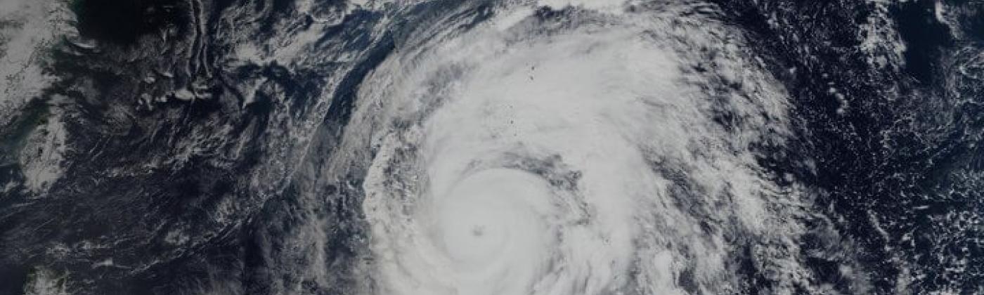
As of Thursday afternoon (October 10), Super Typhoon Hagibis remains a powerful Category 4 equivalent hurricane with maximum sustained wind speeds of 150 miles per hour (240 kilometers per hour). The Japan Meteorological Agency (JMA) has described the storm as “violent” – its highest tropical cyclone classification.
Hagibis hit the headlines in recent days after it underwent one of the most rapid intensifications ever observed: its maximum sustained wind speeds intensified from 60 to 160 miles per hour in just 24 hours on October 6-7. According to media reports, only Hurricane Wilma in 2005 and Patricia in 2015, are known to have strengthened more quickly. Its peak wind speed of 160 miles per hour (258 kilometers an hour) is equivalent to a Category 5 hurricane on the Saffir-Simpson Hurricane Wind Scale.
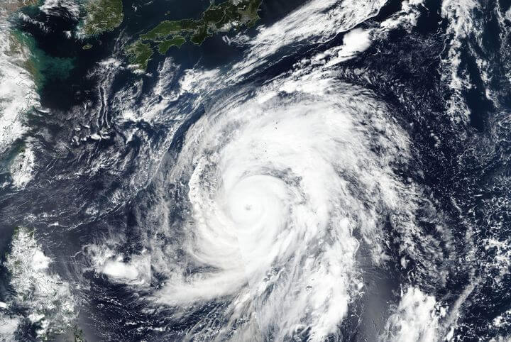
Both the JMA and JTWC agree that Hagibis will weaken as it approaches Japan, but the system is forecast to remain a powerful typhoon when it approaches Honshu – Japan’s main island, on Saturday evening local time. The latest forecasts have Hagibis making landfall in and around the Tokyo Bay area and the surrounding prefectures, but there remains some uncertainty in the forecasts around its precise landfall position and intensity.
Regardless of its final landfall intensity and location, the storm’s broad wind field is expected to bring damaging winds to a large swath of central and eastern Honshu. The JMA are also warning that Typhoon Hagibis could bring significant amounts of rain – up to 700 millimeters (27 inches) and waves up to 8-9 meters (26-29 feet) to some areas of Japan over this weekend, which could cause localized flooding.
A Month After Faxai
Hagabis poses a significant risk to life and property across southeastern Japan and comes just a month after Typhoon Faxai made landfall on September 9; and many of the affected areas are still recovering. Media reports state that volunteers are calling on residents to make an early evacuation from Chiba prefecture, where more than 34,000 homes are still in need of repair. Tokyo Electric Power Company (TEPCO) has almost completely restored power to the prefecture after Faxai, and is checking installations ahead of Hagibis.
Preparing for Hagibis
There has been widespread coverage in the media about the major sporting events that could be disrupted. Two out of the three scheduled Rugby World Cup matches due to be held on Saturday have been called off. The match between England and France at the International Stadium Yokohama, expected to attract up to 70,000 fans, and New Zealand versus Italy at the City of Toyota Stadium, have been cancelled by tournament organizers. Ireland versus Samoa in Fukuoka on Saturday is not forecast to be impacted by Hagibis as is expected to go ahead as planned.
The FIA, the governing body of Formula 1, is “closely monitoring” the situation as final practice and qualifying for the Formula 1 Japanese Grand Prix takes place on Saturday at the Suzuka Circuit, some 200 miles southwest of Tokyo, ahead of the Grand Prix on Sunday. The Japanese Grand Prix is no stranger to typhoons: qualifying was postponed in both 2004 and 2010 because of the threat of a typhoon. In both cases, the session was rescheduled for Sunday morning, with the race getting underway in the afternoon.
All Nippon Airlines (ANA) have announced that all domestic flights departing and arriving on Saturday at Narita and Haneda airports will be cancelled. Japan Airlines has cancelled some international flights, and the East Japan Railway, Central Japan Railway and West Japan Railway will cancel trains or have warned of delays.
All eyes will be on when Hagibis makes its northeast turn through Friday. To keep across the latest forecasts and impacts, follow RMS on Twitter and stay tuned to the blog for future updates. RMS clients can access the latest information via RMS Owl.
Share:
You May Also Like
July 03, 2024
Major Hurricane Beryl Breaks Records As It Impacts The Caribbean
Based in London, James is an Assistant Director within Moody's RMS Event Response team, supporting real-time event response operations and assisting on various event response projects. James holds a bachelor’s degree in Physical Geography and Geology from the University of Southampton and a master’s degree in Applied Meteorology from the University of Reading.