Australia Earthquake Hazard: Now Reduced by Up to Seventy Percent
Jochen WoessnerOctober 25, 2018
On October 18, 2018, Geoscience Australia (GA) released its latest view of earthquake hazard for Australia. A headline finding from the 2018 National Seismic Hazard Assessment (NSHA2018) is the reduction of the 475-year peak ground acceleration hazard estimates on rock conditions by up to 70 percent. While GA had updated the Australian seismic hazard model in 2012 (Burbidge et al., 2012), the basis of the Australia building code is a 1991 map described by McCue (1993) which is included in the Global Seismic Hazard Map (figure 1 below) published nearly twenty years ago (Global Seismic Hazard Assessment Program (GSHAP); Giardini, 1999). This 2018 update is pivotal in addressing the long running scientific debate started since.
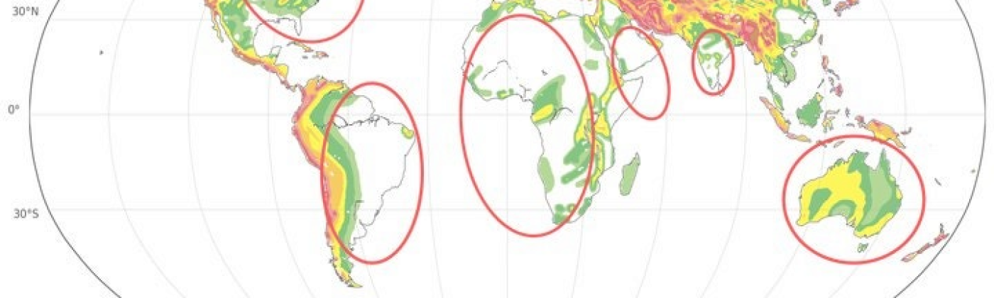
Figure 1 illustrates the 1999 GSHAP view of seismic hazard for 475-year peak ground accelerations on rock conditions. Such levels of ground motion have a ten percent chance of being exceeded in a 50-year window. The red ovals outline the stable continental tectonic settings. It is evident that seismic hazard levels were larger in Australia compared to other similar regions such as Canada and Northern Europe. Scientists have debated why this should be the case.
Figure 1: Global seismic hazard map (GSHAP, 1991) displaying the 10 percent exceedance probability in 50 years for Peak Ground Acceleration (PGA). Red ovals roughly outline stable tectonic regions.
GA scientists have now addressed this question with unprecedented scrutiny. Within the NSHA2018, the earthquake catalog data — the basis for earthquake recurrence estimates, and the ground motion model, defining ground shaking estimates as a function of magnitude and distance, have been revised.
In the catalog, estimates of the local Richter magnitude (ML) have been reassessed leading to a revised national earthquake catalog with homogeneously determined local Richter magnitudes. Next, GA scientists developed a new conversion from ML to the moment magnitude scale (MW). Moment magnitude is the scale of choice used across the globe as the basis for ground motion prediction equations and seismic hazard assessment. Broadly speaking, for magnitudes above 4, moment magnitudes (MW) are roughly 0.3 units lower than local Richter magnitudes. The new NSHA2018 ground motion model includes several equations that lead to lower ground shaking estimates than in the previous version. Both reassessments are well aligned with scientific findings around the globe.
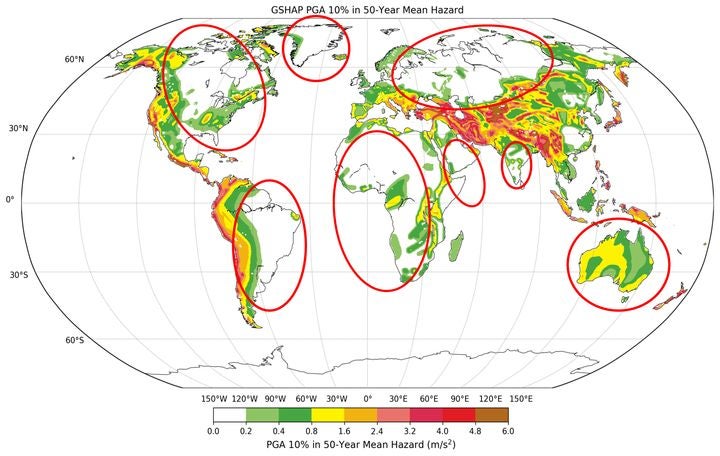
The consequence of the updates is reduced seismic hazard estimates for Australia, based on well-founded best practices for a probabilistic seismic hazard assessment and for evidence-based science. Figure 2 shows how the revised NSHA2018 model brings Australia in-line with other similar tectonic regions of the world.
Figure 2: Same as Figure 1 including pre-release NSHA18 results in the map.
Of course, a hazard model is only one component of a risk model. To provide a more complete view of earthquake risk to the (re)insurance industry, RMS revised all components of the RMS Australia Earthquake Model including hazard and vulnerability. Of particular importance were lessons recently learned from the 2011 Canterbury earthquake sequence in New Zealand, and its effects on the built environment.
While the headline message is earthquake hazard and risk across Australia has reduced, there are spatial variations across the country. Further, there are differences by line of business and variations by building height and construction class. Not every portfolio will see the same changes because of the model update.
Finally, it is important to remember, lower seismic hazard does not mean large magnitude events could not occur tomorrow. Scenarios of significant events close to Australia’s capital cities remain valid. The updated seismic hazard assessment only means the probability of these events occurring is lower than before.
References:
Giardini D (1999) The Global Seismic Hazard Assessment Program (GSHAP) —1992/1999. Ann di Geofis 42:957–974. doi:10.1111/j.1365-3121.1992.tb00609.x
Burbidge, D. R., M. Leonard, D. Robinson, and D. Gray (2012). The 2012 Australian earthquake hazard maps, in The 2012 Australian Earthquake Hazard Map, D. R. Burbidge (Editor), Geoscience Australia Record 2012/71, 108–116.
McCue, K. F. (1993). The revised Australian hazard map, 1991, Proc. of the Australian Earthquake Engineering Society Conference, Sydney, Australia, 25 September 1992, 21–25.
Jochen is a lead modeler in the earthquake model development team at Moody's RMS and is based in Zurich.
Since joining Moody's RMS in 2014 after 15 years in academia, he has focused on transferring latest earth science to earthquake risk models in the Asia Pacific region.