Twenty-Six Days: A Short Respite Between Typhoons Jebi and Trami
James CosgroveOctober 03, 2018
Typhoon Trami ravaged the southern coastline of Japan this weekend, only 26 days since Typhoon Jebi made landfall on September 4. Trami first swept through the southwest chain of Nansei Islands, and then skirted along the southern coasts of the islands of Kyushu and Shikoku, eventually making landfall over Wakayama Prefecture in the Kansai Region, during the evening of Sunday, September 30.
The southwest of Japan bore the brunt of Trami, and as of Tuesday, October 2, the Japan Fire and Disaster Management Agency (FDMA) reported a total of 2,494 buildings damaged across 32 prefectures, with 1,749 of the 2,494 damaged buildings reported as “partially damaged”, and 108 buildings “destroyed” or “partially-destroyed”. A further 637 buildings were flooded in the event. At least 195 people across 29 prefectures have been injured, with many hurt by windows shattered in high winds. 750,000 homes across Japan lost power, together with significant disruption to transport. These numbers are expected to rise as damage assessments conclude.
Four hundred miles southwest of the Japanese mainland on Okinawa Island, the largest of the Nansei Islands with a population of 1.3 million, wind gusts reached 126 miles per hour (202 kilometers per hour) at Itokazu locality in Nanjō City. Five or so miles up from Itokazu, winds topped 103 miles per hour (165 kilometers per hour) and gusts exceeded 132 miles per hour (212 kilometers per hour), at the Kadena Air Base.
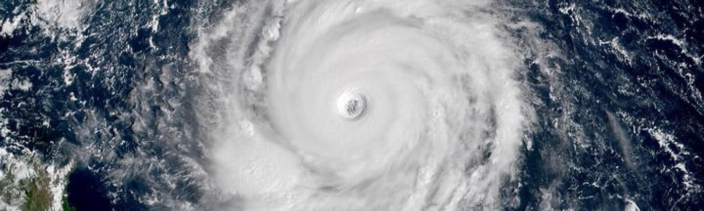
Typhoon Trami, south of Okinawa at peak intensity on September 25, 2018. Image credit: Japan Meteorological Agency
Okinawa Prefecture suffered from flash flooding and high swells, and there are numerous reports of sinkholes affecting both properties and infrastructure. Naha Airport was closed as a precaution from Saturday, September 29 through Sunday, September 30.
Kagoshima Prefecture Fares Worst from Trami
As Trami moved closer to the mainland island of Kyushu, wind speed records were broken at the small, remote Tokara islands, off the southwest coast of Japan, some 80 miles (128 kilometers) southwest of Kagoshima, with a reported gust of 122 miles per hour (196 kilometers per hour). Moving along the southern coast of Kyushu, Kagoshima Prefecture fared worst from the storm. The FDMA reported a total of 2,131 buildings damaged in Kagoshima Prefecture, and of these, 1,594 were damaged by winds and 537 were flooded.
Neighboring Miyazaki Prefecture saw a river burst its banks with a number of flooded houses and farms. Photographs show heavy rain flooding the streets of Miyazaki City (pop. ~399,800). In Saga Prefecture, a portion of a roadside façade collapsed on the Nishikyushu Expressway in Imari (pop. ~55,000). In some parts of Miyazaki, Kochi, and Ehime Prefectures in southern and western Japan, 16 inches (400 millimeters) of rainfall was recorded over the 24-hour period ending at 23:00 local time on Sunday, September 30.
Trami Heads Inland
After landfall in Wakayama Prefecture, the FDMA reported a total of 23 buildings damaged in Shizuoka Prefecture, just 40 miles west of Tokyo. According to the local media, high winds primarily caused superficial damage to roofs, with the storm also uprooting trees and causing widespread power outages across the prefecture. A building at Kasuisai Temple in the city of Fukuroi (pop. ~86,600), is reported to have collapsed during the storm. Photos also show superficial damage to shop fronts and signage in the city of Numazu (pop. ~191,600).
Kanagawa Prefecture, just west of Tokyo Prefecture, saw a total of three buildings damaged. Local media reports indicate that high winds caused superficial damage to properties and their façades across the prefecture. Fujisawa Station, in the city of Fujisawa (pop. ~420,300), sustained damage to its roofing. Photos also show damage to the glass windows of high-rise buildings in the city of Yokosuka (pop. ~409,500).
As Trami tracked northeast, winds gusted to 93 miles per hour (150 kilometers per hour) at Tokyo’s Haneda Airport, located close to the shore of Tokyo Bay. The FDMA reports a total of 79 buildings damaged in Tokyo Prefecture, as high winds caused widespread and primarily superficial damage to properties and their façades across the prefecture.
According to local media reports, many residents have commented that Trami was the strongest typhoon that they have experienced in Tokyo. Some offices and apartments in high-rise buildings sustained damage to glass windows and balconies, and high winds caused superficial damage to the shutters of buildings in the cities of Suginami (pop. ~562,000) and Mitaka (pop. ~189,200).
In the city of Kunitachi (pop. ~75,900), the Yabo Tenman-gū shrine sustained major damage to its roof and walls. At Yokota Air Base, in the city of Fussa (pop. ~58,400), more than 170 trees were toppled by high winds, breaking windows and causing significant damage to vehicles and the walls of several buildings. High winds uprooted trees across the prefecture, including in the wards of Meguro, Shinjuku, and Suginami, and in the district of Minato. At the stations of Yotsuya and Naka-Itabashi, where trees were uprooted near train tracks and roads, this caused further damage and disruption.
Disruption to transport was widespread, and more than 1,000 flights were canceled from multiple airports, including Tokyo’s Narita and Haneda airports as well as Kansai International Airport, Osaka Prefecture, which closed two of its runways as a precaution. The cancelations are reported to have affected more than 100,000 people.
The East Japan Railway Co. suspended all train services in the Tokyo area on Sunday evening as a precaution — reportedly the first time that the rail operator has taken such action, which then went on to affect more than 910,000 people. Around 120,000 people were affected by disruptions and cancelations of shinkansen bullet train services operated by the Central Japan Railway Co., according to the railway operator.
The break between Trami and the next typhoon to impact Japan may be short lived as Typhoon Kong-rey makes its turn northwest towards South Korea and Japan, potentially passing over the Nansei Islands and Kyushu.
Share:
You May Also Like
July 03, 2024
Major Hurricane Beryl Breaks Records As It Impacts The Caribbean
Based in London, James is an Assistant Director within Moody's RMS Event Response team, supporting real-time event response operations and assisting on various event response projects. James holds a bachelor’s degree in Physical Geography and Geology from the University of Southampton and a master’s degree in Applied Meteorology from the University of Reading.