The Great Kanto Earthquake: 100-Year Retrospective
Chesley WilliamsSeptember 01, 2023
At 11:58 JST on Saturday, September 1, 1923, an Mw7.9 earthquake struck the Tokyo, Japan region. The reported ground shaking lasted longer than four minutes and caused extensive damage to buildings and infrastructure. Total damage at the time of the event is estimated at 6.5 billion yen which is assessed by Moody’s RMS to increase to 48.5 trillion yen or $331B in economic loss in today’s dollars.
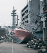
While the damage from the strong ground shaking was severe and widespread, fires triggered by the earthquake swept through a substantial part of the city causing significant additional damage. It was estimated that 70 percent of the structures were destroyed across the Tokyo region and including Yokohama. Other processes that contributed to the damage across a wider region included liquefaction, land sliding, and tsunami waves. While tsunami waves caused very little damage within Tokyo Bay, the coastal regions of Kanagawa, Shizuoka and Chiba prefectures did experience very large damaging waves.
In all, the event impacted seven prefectures including Tokyo, Chiba, Ibaraki, Kanagawa, Saitama, Shizuoka, and Yamanashi. The ground shaking was felt over a wide area from southern Hokkaido to the Chugoku and Shikoku regions. Regrettably, casualties were very significant with estimates that more than 100,000 people perished which represented about two and a half percent of the total Tokyo metropolitan region population at the time.
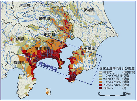
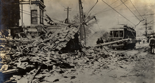
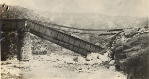
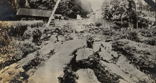
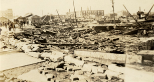
Source: Moroi, T. and M. Takemura, (2002). Damage levels mapped to JMA intensities: less than 5 (grey), 5 minus (pale yellow), 5 plus (pale green), 6 minus (orange), 6 plus (red) and 7 (dark red).Source: Photographer William Dana Reynolds. Residential building damage from ground shakingSource: Photographer William Dana Reynolds. Railway bridge collapsed due to ground shakingSource: Photographer William Dana Reynolds. Fissures in road due to liquefaction and Lower Right region impacted by fire.Source: Photographer William Dana Reynolds. Region impacted by fire
Prior to the Great Kanto event, Tokyo had experienced several damaging earthquakes including the 1855 Ansei Edo Earthquake. In the two decades prior to the 1923 earthquake, the population had essentially doubled to almost four million and the geographic extent of the city had expanded rapidly.
The region became a hub for industrial production with nearby Yokohama becoming the main seaport for Japan. The city’s construction was dominated by brick masonry and reinforced concrete structures, built without seismic design requirements. In the poorer, more densely populated regions of the city, the buildings were predominantly constructed from wood, clustered around narrow roads and alleyways.
On the morning of September 1, 1923, the weather was muggy and windy impacted by a typhoon that had passed over Kyushu the previous day weakening as it pushed into the Japan sea. Many people were preparing their midday meals using their cooking stoves when the event struck very close to noon, and as a result, the earthquake then triggered hundreds of fires across the city.
These fires then coalesced, pushed by the windy weather into a conflagration that swept across a significant swath of the city and burned for three days. Once the fires were extinguished, the estimate showed that 70 percent of the structures in the city were destroyed including a burn area totaling more than 30 square miles.
It was the more densely populated poorer neighborhoods with their wood construction, narrow streets and alleyways that suffered the worst damage, and the bulk of the reportedly casualties resulted from the fires.
When totaled, almost 300,000 buildings across the wider Tokyo/Yokohama region were destroyed, with ~212,000 burned, ~80,000 collapsed and another ~80,000 partially collapsed. This left more than one and a half million people homeless which led to a very significant refugee migration away from the city. The total damage is estimated at 5.5-6.5 billion yen which was more than a third of the Japan GDP at the time.
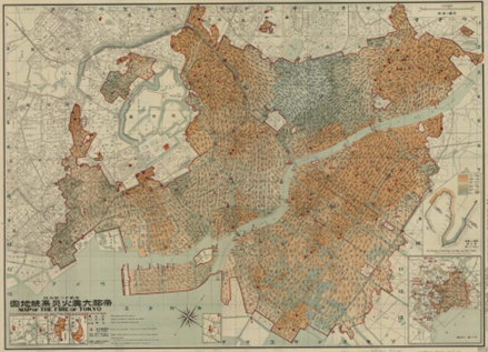
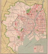
Source: Relief Information Bureau, (東京帝国大学羅災者情報局調査), “Map of the fire of Tokyo” (帝都大震火災系統地図)” (1923)
The fire because of the Great Kanto Earthquake was the largest urban fire to date. The city government responded with an ambitious reconstruction effort. Passing the City Planning Act of 1924, this allowed the city to claim up to 10 percent of a property area (with no compensation) to allow for the re-adjustment of city lots.
The goal was to reconstruct the city to be more fire resistant, with wider, safer streets and by adding numerous parks as fire breaks. It also interesting to note that based on the observation of building damage, in 1924 Japan introduced the first building codes in the world that included a seismic design calculation method.
Today, Tokyo is the largest metropolitan region in the world with a population of more than 35 million – almost 10 times larger than in 1923. Tokyo also sits on one of the most seismically active and tectonically complex locations in the world.
Three tectonic plates converge under the Tokyo metropolitan region: the Philippine Sea, the Pacific, and the Okhotsk plates. The 1923 event occurred along the interface where the Philippine Sea plate is pushed beneath the Okhotsk plate on which the Japanese Island of Honshu sits. This interface is called the Sagami Trough which was the source of the larger 1703 M8.2 Genroku Earthquake that also caused significant destruction, fires, and loss of life in Tokyo.
Using Moody’s RMS Japan Earthquake and Tsunami HD Model, for a repeat of the 1923 Great Kanto Earthquake today, we estimate the economic losses would be on the order of 48.5 trillion JPY or US$331 billion.
This loss estimate includes losses to property and business interruption and accounts for post-event loss amplification factors such as increases in the pricing for material and labor. However, a major difference from the actual event, the bulk of the loss, if the event were to occur today, is driven by shake damage with fire contributing only seven percent of the losses and just a very small contribution from tsunami.
There are several reason why the fire losses are a much smaller percentage today. First, the reconstruction following the 1923 fires with the wider streets and inclusion of more, larger parks would mitigate the ability of fires to spread and to coalesce into large conflagrations. Today, in the highest populated parts of Tokyo the population density is <50% of what it was in 1923. Additionally, the fire suppression systems in Tokyo are much more sophisticated today with lessons learned from many events including the 1995 Kobe earthquake which had a significant component of its damage due to fires. Moreover, fire and seismic design requirements for structures built in Japan are some of the most sophisticated in the world limiting the overall damage, the potential for fire ignitions and protecting lives.
The 1923 event was the last major damaging earthquake to directly hit the Tokyo region. Tokyo has a long history of damaging events including the 1703 M8.1 Genriku Earthquake and the 1855 M7 Ansei Edo Earthquake. The most significant damaging event for Japan in recent years was the 2011 M9.0 Great East Tohoku Earthquake. The 2011 event impacted more remote parts of Japan and had a very significant component of losses due to tsunami waves. The estimated loss level for a repeat of the 1923 event (48.5 trillion JPY) is roughly three times the economic impacts observed during the 2011 event. Based on the Moody’s RMS Japan Earthquake and Tsunami HD Model, we estimate that insurance will cover just more than a third of the economic loss level.
In September, Moody’s RMS will be publishing a white paper that expands on the potential impacts of a repeat of the 1923 event.
Reference:
Moroi, T. and M. Takemura, (2002). Re-evaluation of the damage statistics of wooden houses for the 1923 Kanto earthquake and its seismic intensity distribution, Journal of Japan Association for Earthquake Engineering, 2-3, 35-71 (in Japanese with English abstract).
Chesley manages the commercial development of the Moody's RMS earthquake and tsunami models for the Asia-Pacific region. Chesley joined the Model Development Group at RMS in 1995, with expertise in developing seismic source models.
Through her tenure at Moody's RMS, Chesley was a model developer for key products including the 2018 Moody's RMS Japan Earthquake and Tsunami HD model and earthquake models for Europe, Asia, and Latin America. Chesley has recently shifted roles from model development to product management to use her years of experience at Moody's RMS to facilitate strategic product development, product marketing, and product management.
Chesley holds a master's degree in geophysics from Stanford University, where she researched ground deformation associated with the 1989 Loma Prieta earthquake.