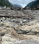
The February 22, 2011 earthquake in Christchurch New Zealand was notable for the severity of liquefaction in the Eastern part of the city. So much water was expelled at the surface that it led to widespread flooding. Extreme consolidation of the underlying sediments had all kinds of secondary effects, causing buildings to split and tilt. The flooding even became a source of loss in its own right. We have not seen anything like this in earthquakes of the last few decades. So where else has it been encountered?
Soon after 2 p.m. local time on January 15, 1934 an English sahib was driving along a road in the wide valley of the Ganges in Northern India.
“…my car suddenly began to rock in a most dangerous fashion… then water spouts, hundreds of them throwing up water and sand were to be observed on the whole face of the country, the sand forming miniature volcanoes, while the water spouted out of the craters; some of the spouts were quite six feet high.”
“In a few minutes, on both sides of the road as far as the eye could see, was vast expanses of sand and water, water and sand. The road spouted water, and wide openings were to be seen across it ahead of me, then under me, and my car sank, while the water and sand bubbled and spat, and sucked, till my axles were covered. ‘Abandon ship’ was quickly obeyed, and my man and I stepped into knee deep hot water and sand and made for shore. It was a particularly cold afternoon, and to step into water of such temperature was surprising.” Dunn, J.A., Auden, J.B.& Ghosh, A.M.N., 1939. Earthquake effects, Mem. Geol. Survey of India, 73, 27-48.
The area of extreme liquefaction in the magnitude 8.1 1934 earthquake was known as “the Slump Belt.” It extended for 300 km along the axis of the Ganges Valley and covered an area of 46,000 km2, including a number of major towns, although the intensity of liquefaction was not everywhere as impressive as in this account.
We find similar observations in some accounts of the New Madrid earthquakes of 1811-1812.
“I happened to be passing in its neighborhood where the principal shock took place…the water that had filled the lower cavities…rushed out in all quarters, bringing with it an enormous quantity of carbonized wood…which was ejected to the height of from ten to fifteen feet, and fell in a black shower, mixed with the sand which its rapid motion had forced along; at the same time, the roaring and whistling produced by the impetuosity of the air escaping from its confinement, seemed to increase the horrible disorder of the trees which everywhere encountered each other, being blown up cracking and splitting, and failing by thousands at a time. In the mean time, the surface was sinking and a black liquid was rising up to the belly of my horse, who stood motionless, struck with a panic of terror…These occurrences occupied nearly two minutes; the trees, shaken in their foundation, kept failing here and there, and the whole surface of the country remained covered with holes, which…resembled so many craters of volcanics…” – Bringer L. 1821. Notices of the geology, mineralogy, topography, production, and aboriginal inhabitants of the regions around the Mississippi and its confluent waters. Am. J. Sci. 3:15-46.
In an account of another earthquake in the series: “…about sunrise another very severe one came on, attended with a perpendicular bouncing that cause the earth to open in many places…the deepest I saw was about twelve feet. The earth was, in the course of fifteen minutes after the shock…entirely inundated with water. The pressing of the earth, if the expression be allowable, caused the water to spout out of the pores of the earth, to the height of eight or ten feet! The agitation of the earth was so great that it was with difficulty any could stand on their feet, some could not. The air was strongly impregnated with a sulphurous smell.” – Fletcher J. 1812. Narrative dated Jan. 21, 1812. In Pittsburg Gaz., Feb. 14,1812 issue.
So what was witnessed in Christchurch was not unprecedented. At the same time in well-documented earthquakes over the past 200 years, we can find serious flooding from ultra-liquefaction in only a small number of cases.
Liquefaction occurs in a loose sediment saturated with water, when the sand particles are only touching each other at the corners. Vibrations jiggle the particles to pack together more tightly. The reduction in space pumps up the fluid pressure forcing the grains apart, so instead of transmitting loads through the touching grains, the medium has become a low friction fluid. The pressurized water will attempt to escape up cracks and fissures to the surface where the pressure can be relieved. The amount of water that emerges reflects the volume reduction of the sediment. Typically liquefaction leads to scattered sand volcanoes, miniature sand hills perhaps 30 to 100 cm high, formed from the sand deposited where the water emerges at the surface. However in the phenomenon seen in the Ganges Valley India in 1934, Christchurch in 2011, and New Madrid in 1811, so much water emerges at the surface that it leads to flooding that can be 200 mm or more deep.
This means there has been a big volume reduction of the sediment. Two hundred millimeters of water could represent a 2% reduction in volume over a 10 m thick layer of sand or 5% over 4 m. Liquefaction is almost always shallower than 15 m, as the weight of the overlying soil compacts the sediment, the extra load makes it more difficult for the particles to become re-arranged, and the strength of vibrations reduces into the ground.
What are the factors that predetermine ultra-liquefaction? These are some of the principal ones:
- A high water table close to the surface.
- Irregular “sharp” sand or silt grains, which touch at corners and can achieve a large volume reduction as they move around. Glaciers are the best generators of “sharp” sand, as they grind rocks apart, unlike rivers that bounce grains so they grow rounded.
- The layer of unconsolidated sediment must be thick – i.e. deposited in deep water.
- The particles of sediment should settle on top of each other without disturbance – away from currents or waves.
- The sediment should not be too old or the particles will become cemented together. Most liquefaction occurs in sediments deposited in the past 10,000 years.
- Each past episode of water venting after liquefaction causes irreversible reductions in the capacity for further consolidation. Therefore the fewer the episodes of past liquefaction the better.
- Finally it takes strong earthquake shaking to cause enough particle movement.
This means the optimal conditions for extreme liquefaction could include: a) proximity to glaciated uplands with rapid rates of erosion, b) fed by short rivers, c) leading to deep water deltas in a lake or the sea, d) with few previous episodes of intense shaking since sediment deposition, and e) high levels of ground shaking.
How do the three reports of ultra-liquefaction compare?
The eastern half of the city of Christchurch was built on delta swamps, underlain by sediments deposited in a sheltered coastal lagoon from short rivers sourced from glaciers only 60 km to the north, eroding mountains undergoing rapid tectonic uplift.
The Ganges Plain lies within 100 km of the Himalayan mountain front and is fed with sediments eroded by glaciers and rockslides passing down steep mountain torrents into the Ganges Flood Plain. The Lower Ganges river valley, where the strong liquefaction was observed in 1934, is about 500 km from the sea, and was deeply eroded during the last Ice Age when sea levels sunk to 130 m below current levels. This lower river canyon was infilled with sediments as sea levels underwent their rapid recovery after 20,000 years BP.
The Lower Mississippi River was also deeply eroded at the time of lowered Ice Age sea levels. The edge of the Laurentian Ice sheet reached 200-300 km south of Lake Michigan and fed glacially eroded sediments into the Mississippi River, which infilled this canyon as sea levels rose rapidly. New Madrid is around 600 km from the sea.
Therefore the three locations seem to tick most of the boxes identified as defining the preconditions of ultra-liquefaction. The one piece of information missing is their history of strong shaking since the sediments were deposited (although close to New Madrid older episodes of strong liquefaction have been identified).
In a future post I will report on towns and cities around the world which could, according to these criteria, be potential candidates for future ultra-liquefaction.