Emergency Management: Importance of Managing Risk to Critical Infrastructure and Public Assets
Laurence CarterNovember 30, 2020
Over the past decade, many of the largest natural disasters across the globe have also been associated with either damaged or failed critical infrastructure. The 2011 Tōhoku Earthquake and tsunami led to an major incident at the Fukushima Daiichi nuclear power plant, requiring the long-term evacuation of 160,000 citizens from contaminated areas. Following Hurricane Sandy in October 2012, over eight million customers were without power across the northeastern U.S. after the failure of the electricity grid. Sometimes, failed infrastructure is pinpointed as the cause of a disaster – with the 2018 Camp Fire in Northern California, the ignition occurred due to a faulty electric transmission line.
Managing emergencies is always exceptionally challenging, but with an ongoing global pandemic, emergency managers working for cities, counties, or states across the U.S. have faced new operational stresses in how to minimize community impacts from natural disasters to infrastructure. One example I would like to highlight was from the end of August this year. Hurricane Laura caused an estimated insured loss of US$9 billion to US$13 billion, damaging large numbers of buildings and leaving around 900,000 customers without power. Damage from Laura caused a chlorine leak and a subsequent large fire at the KIK Custom Products chemicals plant near Lake Charles, Louisiana. Smoke and chlorine gas spread to the surrounding community, and the state’s governor advised citizens to close windows and turn off air conditioners in response to the pollution.
Quickly Assess Location Risk
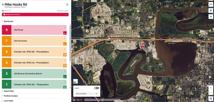
What would be useful to know is whether it could have been predicted that the chemical plant was susceptible to damage from hurricane winds or floods. To do this, plugging the facility’s details into the RMS® SiteIQ™ application, in less than a minute, I found out that the exposure at this plant is at much higher risk relative to most other locations in the U.S. In fact, the facility is at extremely high risk from flood events and at moderately high risk from hurricane.
Figure 1: RMS SiteIQ application shows risk scores (1 low – 10 high) for six hazards at the KIK Custom Products plant
But I recognize that identifying vulnerable buildings after they have already been damaged is not particularly helpful. Perhaps a more pertinent question for an emergency manager to ask is whether the use of available data would have led to different mitigation decisions? Having knowledge that critical infrastructure was at risk could certainly lead to better decisions being taken across the board; from advising on the location of a plant, its operations, incident prevention strategies, through to evacuation procedures. But you need the insight first, and here we can illustrate a general framework for understanding critical infrastructure risk that can be applied to any type of asset, for any hazard, anywhere in the world.
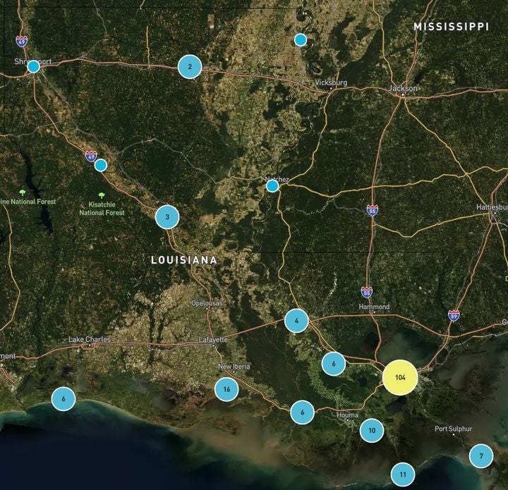
To start with, instead of plugging in details of a single location into the SiteIQ application, a collection of assets can be imported. We can then instruct the application to simultaneously analyze the risk to all facilities in the portfolio and identify those at highest risk of damage. Given the focus here is on chemical plants, I decided to use all the facilities in the Environmental Protection Agency (EPA) Toxic Release Inventory. The portfolio contains 977 individual facilities distributed across multiple counties across the state.
In a matter of seconds, the tool can analyze the risk from six different hazards to all locations. This allows us to quickly see which locations are at the most risk and to determine which perils are driving that risk. Coastal locations in Louisiana are exposed to hurricanes and this drives the risk profile in the state. But perhaps more surprising is that there are a number of locations, much further inland, that are exposed to extreme fluvial flood risk.
Figure 2: RMS SiteIQ application map view of the location of chemical plants across Louisiana
Another interesting finding is that the KIK Custom Products facility, although badly damaged by Hurricane Laura and requiring an extensive rebuild, is not at the top of the highest risk locations. In fact, an emergency manager would have to sift through 179 other chemical plants before arriving at this particular facility. RMS data shows the Lake Charles facility is at high risk, but others pose a higher risk.
Mitigating Risk to Critical Infrastructure
This finding highlights the scale of the problem for emergency managers. Using Louisiana as an example, there are a huge number of high-risk chemical facilities in the state, and that’s before factoring in all the other types of critical infrastructure that may also be at risk. Each state will have its own unique risk profile. For instance, in California and the western U.S. states, earthquake and wildfire risk might drive the risk profile. When examining large city centers, “man-made” risks are also factored into the SiteIQ application, as it can provide scores for the relative risk of a damaging terrorist attack.
In order to have a chance of mitigating risk to all critical infrastructure facilities, there needs to be a process that is conducted at scale, with risk data driving the prioritization of assets. Emergency managers would then need to track a large number of facilities, potentially thousands per state, and ensure that the right mechanisms are in place to reduce the risk to each of them.
Executed correctly, this process would result in fewer, high-profile incidences of catastrophic damage and pollution caused by critical facilities. In turn the likelihood of disruption to critical lifelines would be reduced, and ultimately would enable communities to recover more quickly from major catastrophe events.
Share:
You May Also Like
Laurence Carter
Laurence is a senior consultant in the Capital and Resilience Solutions team and leads the Capital Markets Risk Advisory team in Hoboken, NJ. He works on a broad range of projects aimed at helping both public and private entities assess and manage their exposure to catastrophe risks across the globe.
Laurence has worked on several projects that have been designed to translate RMS’ catastrophe modeling results into decision-useful metrics for the public sector and corporate clients. This has included delivering actionable insight for an entity looking to develop a new windfarm installation, and advising on optimal forest management steps to protect communities in California from wildfire events.
He has extensive experience working with non-profit organizations to develop resilient practices around the globe. This includes developing a model for the Natural Capital Finance Alliance to enable financial institutions to stress-test their lending portfolios against drought scenarios events and working with the U.K. Department for International Development (DFID) to provide quantitative evidence of the potential scale of natural disasters that could be covered by insurance.
Laurence has also led many projects for RMS that relate to the issuance of new catastrophe bonds for insurers and corporate entities. This includes the Riverfront 2017 catastrophe bond issuance, which was later recognized as the Trading Risk Awards 2018 Non-Life Transaction of the Year.
Laurence holds a master's degree in Theoretical Physics from Durham University.