It’s hard to believe that Hurricane Michael, the thirteenth named storm of the 2018 North Atlantic hurricane season, only achieved tropical storm status just two days ago on Sunday, October 7. Tracked by the National Hurricane Center (NHC) since October 2, Michael started out as a broad area of low pressure over the southwestern Caribbean Sea, a couple hundred miles north of Panama.
Becoming more organized as it began to move toward the Yucatán Peninsula, by October 6 it achieved Potential Tropical Cyclone status. Between October 7 and October 8, rapid intensification saw sustained wind speeds jump from 35 miles per hour to 75 miles per hour (120 kilometers per hour) by midday local time on October 8. Skirting between the eastern tip of the Yucatán Peninsula, and the western tip of Cuba, Michael entered the Gulf of Mexico late evening local time on Monday, October 8.
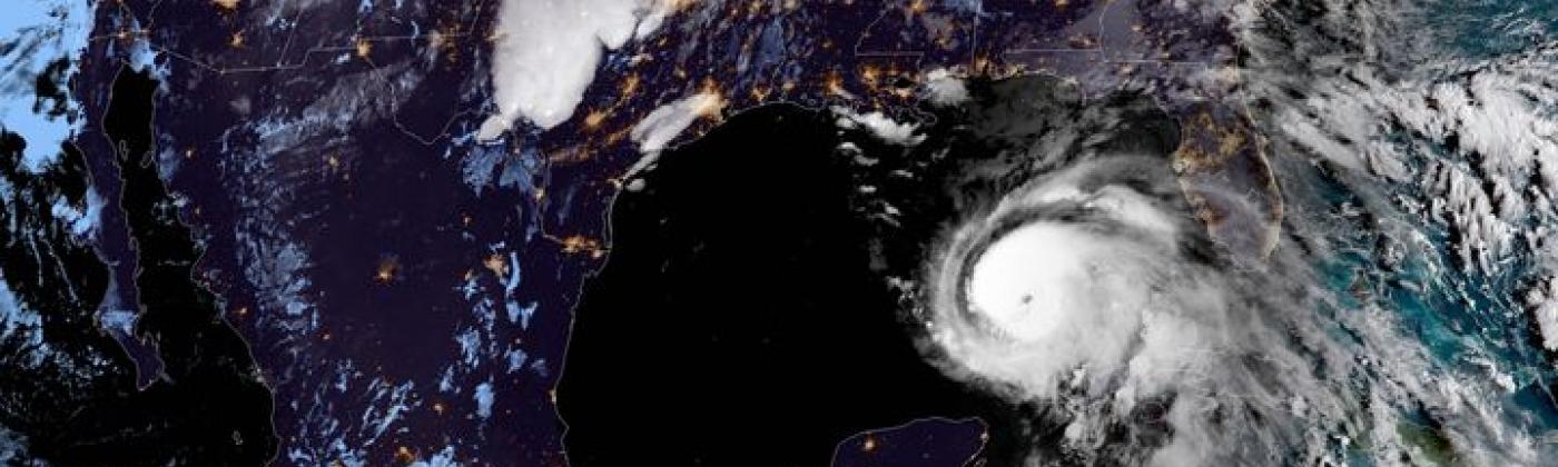
As of 09:00 UTC today (Tuesday 9), the latest NHC advisory located Michael at about 420 miles (680 kilometers) south of Panama City, Florida and about 390 miles (630 kilometers) south of Apalachicola, Florida, with sustained winds at 90 miles per hour (150 kilometers per hour), placing it as a Category 1 hurricane on the Saffir-Simpson Hurricane Wind Scale (SSHWS). Michael is moving toward the north-northwest at close to 12 miles per hour (19 kilometers per hour). Hurricane-force winds extended outward up to 40 miles (65 kilometers) from the center and tropical-storm-force winds extended outward up to 195 miles (315 kilometers).
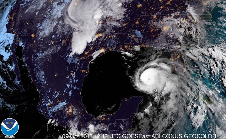
NOAA GOES-East CONUS GeoColor image at 12:12 UTC October 9, 2018. Image credit: NOAA
Michael will make landfall tomorrow (Wednesday, October 10), and over the last 24 hours, the NHC “Cone of Uncertainty” and many of the model solutions have agreed on a landfall on Wednesday afternoon local time near Panama City, Florida. Our RMS HWind team currently highlights Panama Beach and Destin in Florida, two locations some 50 miles (80 kilometers) apart, as the cities most likely to be impacted. Despite this agreement, there is always uncertainty in track and intensity between now and landfall, as evidenced by the forecast changes in Hurricane Florence within 48 hours of landfall.
Media reports suggest emergency preparations and declarations are quickly being put in place in more than 100 counties spanning from Mobile, Alabama, through the Florida Panhandle and into the Florida Big Bend region, ranging across some 300 miles (482 kilometers), from tropical storm and storm surge warnings and alerts.
Michael and the Need for Speed
What has been particularly unusual about Michael is that the system has continued to strengthen despite the presence of moderate wind shear. And, with the wind shear set to diminish, Michael is then expected to strengthen further, and this intensification could be even more rapid, as sea surface temperatures in the Gulf of Mexico remain one to two degrees Celsius above average. Michael is expected to make landfall as a major hurricane of Category 3 strength.
Because Michael is expected to be a fast-moving storm, the potential impacts are almost the opposite of what we saw in Florence. A fast-moving storm mitigates the possibility of high rainfall totals that would be caused by a slow-moving or stalled storm. At present, a maximum of ten inches of rain is forecast to fall over the Florida panhandle and southern Georgia. By comparison, Florence caused upwards of 20 to 30 inches of rain across much of the Carolinas. Thus, flood is not expected to be a large loss driver with Michael.
The speed of the storm means that after it makes landfall on Wednesday 10, it is forecast to enter the Atlantic near Norfolk, Virginia overnight on Thursday 11, at tropical storm strength. Maintaining some intensity farther inland, Michael is forecast to retain at least tropical storm strength as it crosses Georgia and the Carolinas, so Michael’s overall wind swath could be broad. By contrast, Florence weakened quickly at landfall and its slow forward motion restricted its most damaging winds closer to the landfall point. Up to four to six inches of rain is currently expected over the Carolinas, which is still recovering from the floods caused by Hurricane Florence.
The Big Bend region of Florida is typically at risk from hurricane storm surge due to its shallowly sloped coastline, which allows for water to build up as the storm moves ashore. Severe storm surge is a possibility over a large portion of the Florida panhandle, with the highest surge expected to the right of the storm’s track. Current projections forecast large swaths of coastline exposed to storm surges reaching more than nine feet above sea level.
From a modeling perspective, RMS has looked at historical benchmarks — past storms that have made landfall in this region at similar strength using 2018 Industry Loss Curves, and the most common comparisons made thus far include Eloise in 1975 (US$3.6 billion), Opal in 1995 (US$4.1 billion), and Dennis in 2005 (US$1.2 billion). These historical benchmarks are not loss estimates. Of these, Eloise has the track closest to the current forecast, while Opal and Dennis made landfall further to the west.
Also of note, Hurricane Hermine impacted this region in 2016 as a Category 2 storm, which was weaker than the current forecast for Michael. Hermine brought down a number of trees along the coast and near Tallahassee, so there are fears that Michael may do the same and even worse.
With the countdown until landfall rapidly ticking away, unlike the slow, stalling approach of Florence, time to prepare for the impact of this major hurricane is unfortunately in short supply. Follow RMS on Twitter, LinkedIn the RMS blog and RMS clients can get the latest information from RMS OWL.
Robert Muir-Wood works to enhance approaches to natural catastrophe modeling, identify models for new areas of risk, and explore expanded applications for catastrophe modeling. Robert has more than 25 years of experience developing probabilistic catastrophe models. He was lead author for the 2007 IPCC Fourth Assessment Report and 2011 IPCC Special Report on Extremes, and is Chair of the OECD panel on the Financial Consequences of Large Scale Catastrophes.
He is the author of seven books, most recently: ‘The Cure for Catastrophe: How we can Stop Manufacturing Natural Disasters’. He has also written numerous research papers and articles in scientific and industry publications as well as frequent blogs. He holds a degree in natural sciences and a PhD both from Cambridge University and is a Visiting Professor at the Institute for Risk and Disaster Reduction at University College London.