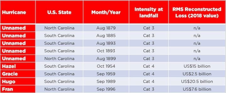
The forecasts for Hurricane Florence have been unusually consistent this far in advance of an anticipated landfall, projecting its path to cross the coast of the Carolinas at major hurricane intensity. For some perspective, if we look at the historical hurricane record since 1850, we find major hurricane landfalls are quite rare along this part of the U.S. Atlantic coastline:
RMS Reconstructed Loss values are based on wind and storm surge damage to present-day exposure, and not on trending forward historical losses
Over the past 167 years, there have been just nine major hurricanes that made landfall along the coast of North and South Carolina. So, on average we can expect one major landfall along this 490-mile stretch of coastline every eighteen and a half years. Certainly, a rare event. Only three of these storms — Hazel, Gracie, and Hugo — were Category 4 (on the Saffir-Simpson Hurricane Wind Scale) at landfall. There has never been a Category 5 landfall north of Florida.
Could Florence be the next Hazel … or Hugo?
Florence has consistently been forecast to reach its current intensity of Category 4 strength before making landfall along the North Carolina coast. The closest historical storm that made landfall over this immediate area at Category 4 strength was Hurricane Hazel in October 1954. Officially, Hazel was not a North Carolina landfall since it struck the coast just north of Myrtle Beach, South Carolina, some five or so miles from the state line. Just prior to landfall, Hazel tracked through anomalously warm Gulf Stream waters and re-intensified to Category 4 strength.
Then there are comparisons with 1989, and local media has already asked the second question — could Florence be the next Hugo? Hugo is easily the most notable Category 4 landfalling hurricane in the southeast U.S., although this storm made landfall to the south in South Carolina. Hugo caused tremendous destruction across the Carolinas. Given that Category 4 landfalls in this region are rare, local residents’ minds are already turning immediately to Hugo. But at this early stage, it remains to be seen if Florence’s intense wind field will extend far inland like Hugo’s did almost 30 years ago. Current forecasts call for Florence to slow down immediately following landfall, increasing the possibility that damaging wind speeds may be confined at the expense of widespread inland flooding.
My colleague Tom Sabbatelli, who heads-up the RMS Event Response team, has explored this comparison between Hugo, Hazel, and Florence, in a conversation with Bloomberg that explores the potential for losses if history were to repeat itself. Though too soon to tell, if Florence does make landfall in North Carolina at Category 4 strength, it will be the strongest North Carolina landfall and the northernmost Category 4 landfall on record. Florence may achieve Category 5 strength in its approach to the U.S., but storms of this intensity are historically unable to maintain this intensity for prolonged periods of time.
Flooding from Florence
Something that distinguishes Florence from these past major hurricanes is its flood potential. Of course, every hurricane brings with it storm surge (coastal flooding), which can exacerbate damage from wind along the coast. In addition, Florence is carrying an enormous amount of moisture that will fall as rain as the storm tracks inland. Unfortunately, the hurricane is expected to slow down and possibly stall soon after making landfall, which will lead to prolonged periods of heavy rainfall, making the risk of catastrophic flooding even higher.
Just over one year ago, Hurricane Harvey deluged the Houston metro area with over 50 inches (1270 millimeters) of rain and led to disastrous flooding and widespread flood damage. At least for now, the National Hurricane Center is predicting 20 inches of rain accumulation, which may sound benign compared to Harvey, but equates to about 50 percent of the average annual precipitation in Charlotte, North Carolina … from a single event!
To make matters worse, it has been a wet summer for the east coast of the U.S. and Florence will add to a period of excessive rainfall as this region has already experienced three straight weeks of near record-breaking rainfall. For example, Cape Hatteras in North Carolina has already received a year’s worth of rain in 2018. The most recent notable rain event occurred across the Mid-Atlantic and Ohio Valley regions over the weekend, as remnants of Tropical Storm Gordon caused localized flooding. All this rain means that the soils across the region remain very saturated, which increases the flood risk further. In these situations, treefall risk increases significantly, as many trees may be uprooted at lower wind speeds than expected due to loosened roots in moist soils.
As we await Florence’s arrival in the early hours of Friday local time, clearly, both the wind and flood risks from Florence are significant. And as we look back at previous events, although hurricanes making landfall in the Carolinas are rare, the losses through this triple-threat of storm surge, wind and inland flood, could also be significant. These events allow us to set early and very preliminary benchmarks when a hurricane is more than 48 hours from landfall, consistent with methods taken by the insurance industry to stress test portfolios. It is only after a storm makes landfall and a deep analysis of the storm’s impact, including a full event reconstruction using on-site reconnaissance, that RMS issues an industry insured loss estimates to the market.
As always, RMS will be releasing regular pre-landfall information and products to clients and RMS HWind will be releasing real-time wind footprint snapshots every three hours throughout the event, and please follow RMS on Twitter, LinkedIn, Facebook and visit the RMS blog for updates.
Share:
You May Also Like
September 16, 2020
Atlantic Hurricane in 2020: Are We in Store for Another Record-Breaking Year?
Dailey is VP, Model Development at RMS and has served the CAT modeling industry for 20 years. He is responsible for delivering Global Event Response products to RMS clients before (forecast products), during (real-time response) and following (event reconstruction) all major natural catastrophes worldwide.
Pete manages teams in London, U.K. and Florida, dedicated to providing 24/7/365 support as events unfold. Pete is also actively involved in formulating RMS’ strategy for developing climate change risk analytics and solutions.Pete has presented and published on various topics important to risk management including tropical cyclones, severe convective storms, coastal and inland floods, and the relationship of our changing climate to the dynamic landscape of insured and economic risk.
Pete holds degrees in Econometrics and Systems Engineering from Penn and a M.S. and Ph.D. in Atmospheric Science from the University of California, Los Angeles.