Michael Kozar, senior modeler – Model Development, RMS
Steering the Storm
The synoptic patterns that steered Hurricane Irma this past week were complex. Like many intense storms that originate from an African easterly wave, Irma was steered westward across the tropical North Atlantic by the subtropical high to its north. As the storm moved into the Caribbean, a deep mid-latitude trough was sliding eastward across the East Coast of United States. The trough lifted poleward as Irma approached and a ridge steered Irma further to the west through the Turks and Caicos and the southern Bahamas, rather than allowing the storm to turn to the northwest towards the Mid-Atlantic United States.
Behind the trough over the United States, high pressure built in which guided Irma towards Cuba. Eventually, a shortwave trough drove to the southeast, which eroded away the western edge of the ridge, finally turning Irma to the north into Florida this weekend. Ultimately, the ridge of high pressure proved to be stronger than initially anticipated, which allowed for the storm to stay on a westward track longer, bringing the storm to the west coast of the state instead of the east coast.
Intensity Weakens Over Cuba
Warm sea surface temperatures and low vertical wind shear persisted across much of Irma’s track. This favorable environment allowed Irma to reach and maintain category 5 intensity throughout much of its march across the northern Caribbean Islands. Irma did not truly begin a consistent weakening trend until its close encounter with Cuba on Saturday, as the large and mountainous island adversely affected the inner core of the hurricane.
Irma briefly regained some intensity over the Florida Strait prior to striking the Florida Keys. However, increasing vertical wind shear and its proximity to land held Irma’s peak winds somewhat in check for its next landfall near Marco Island. From there, Irma remained over land which facilitated a breakdown of convection in the eyewall and rapid continued weakening. Were the storm to remain offshore until further north (i.e. the Tampa area) as initially thought possible, the storm likely would have weakened more slowly bringing higher winds into the northern half of the state.
Size
Beyond its high intensity, one of the unique aspects of Irma was that it was a very large storm. Irma grew substantially as it moved through the northern Caribbean Islands. In fact, our RMS HWind snapshots indicate that at one point, Irma contained more integrated kinetic energy in its wind field than Katrina did on the day of its Gulf Coast landfall in August 2005.
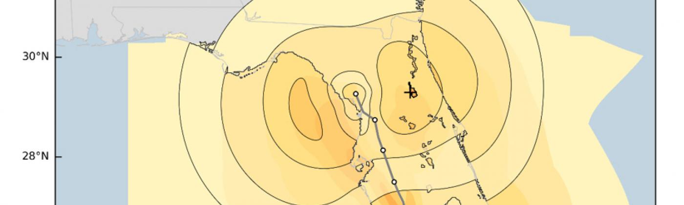
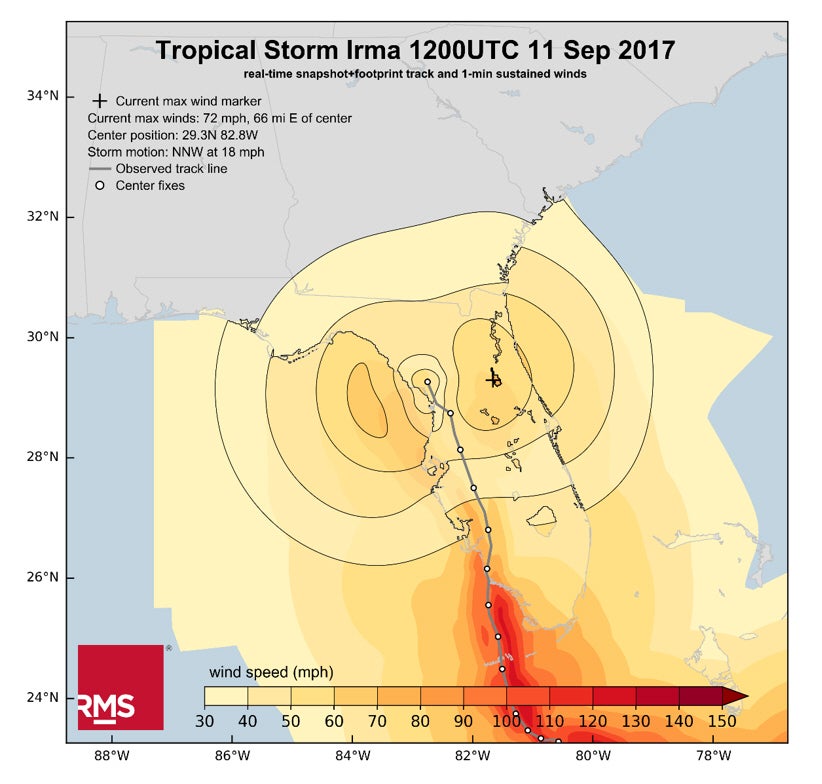
The large size of the storm remained despite the weakening trend after passing along the northern coast of Cuba. As such, the RMS HWind real-time footprint product shows that 1 minute sustained winds in excess of 30 mph blanketed the state of Florida which is causing widespread power outages throughout the state.
Figure 1: Cumulative windfield footprint of Irma as it makes its way along the Florida Peninsula. Contours shown are wind speeds as of 12:00 UTC Monday, September 11.
Michael is a senior modeler on the RMS HWind team based at the Tallahassee, FL office. Michael has a bachelor's and a master's degree in Meteorology from Penn State University and a PhD in Meteorology from Florida State University. He has experience forecasting and analyzing tropical cyclone wind fields and has also studied interannual hurricane variability in the North Atlantic.