Mark Powell, vice president – Model Development, RMS HWind
Don’t Forget About Potential Tropical Cyclone 10L
While we are all deeply concerned for the well-being of those caught up by rising flood waters in the Houston Metropolitan areas, we still need to monitor the tropical Atlantic for additional activity. Hurricane season activity typically goes up this time of year with the peak approaching in the second week of September.
The National Hurricane Center (NHC) has a new term for weather disturbances near the coast that could develop into a tropical cyclone with little advanced notice. These are called “potential tropical cyclones” and we now have Potential Tropical Cyclone 10L (PTC10L) on the coast of North Carolina. The “Ten L” signifies what would be the tenth tropical cyclone in the Atlantic basin this year, should it develop.
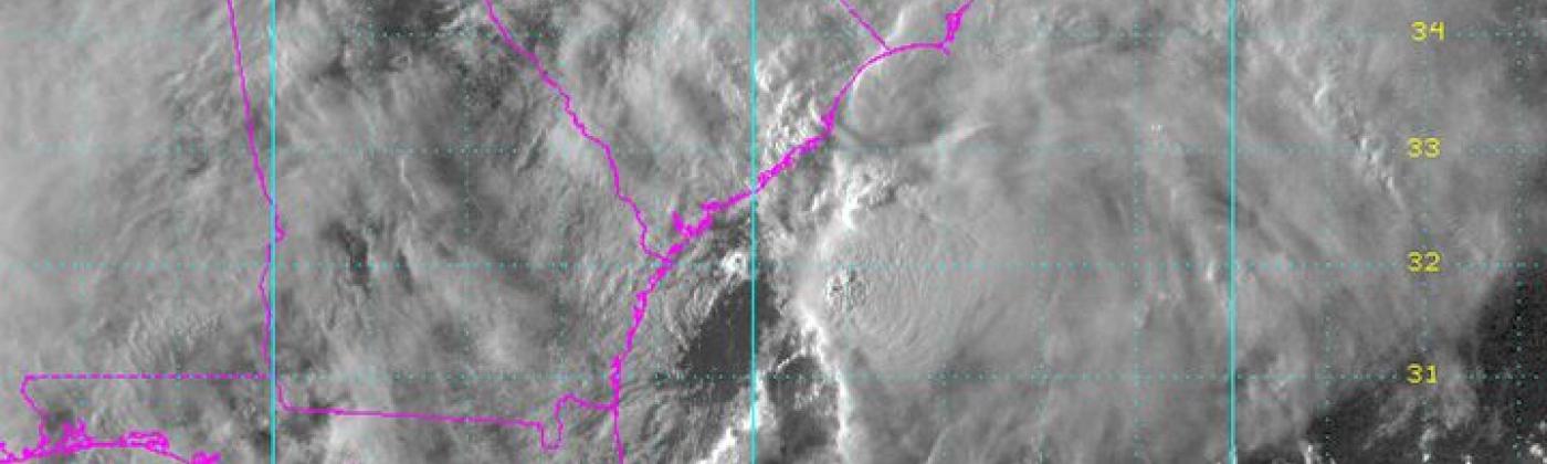
NOAA GOES visible band satellite image of Potential Tropical Cyclone 10L at 22:45 UTC on 28 August.
At the RMS-HWind Forecast Center, we are monitoring Harvey, PTC10L, and a system off the west coast of Mexico, 24/7. The U.S. Air Force Hurricane Hunters flew a reconnaissance mission into PTC10L on Monday afternoon Eastern Time (ET) and found winds near tropical storm strength but a storm circulation center was difficult to identify. Satellite imagery shows most of the deep convection to the east of an elongated low-pressure trough. The system is being affected by strong westerly winds at upper levels that have prevented any alignment between the clouds and the trough. For a tropical cyclone to form, both the convection and the low pressure need to be in close proximity, together with a well-defined cyclonic circulation. This alignment allows the latent heat release from the clouds to help lower the pressure and feedback into stronger, more organized, cyclonic circulation.
There is a 50 percent chance this system will develop, but it is already on the coast and under the influence of a mid-latitude weather system that will steer it along and then past the North Carolina outer banks by this afternoon ET, and then further offshore to the northeast where it should develop extratropical storm characteristics and stronger winds. In summary, PTC10L is running out of time, but could become a short-lived wind and storm surge threat to the North Carolina outer banks.
Elsewhere in the tropics, the NHC has identified Invest 93L, a tropical wave that has just emerged from Africa, with a 70 percent chance of becoming a tropical depression over the next two days. Invest 93L is expected to move westward for the next few days. Next, and possibly the system most likely to become a significant tropical cyclone, is system EP94 in the eastern Pacific, which NHC assigns an 80 percent chance of development, potentially impacting southwest Mexico and Baja California del Sur over the next few days.
Meanwhile Tropical Storm Harvey is still sitting offshore Texas but is experiencing strong shear that will prevent it from regaining Hurricane status before moving inland into Louisiana on Wednesday. Unfortunately, there is no immediate respite from the rainfall in the Houston area.
Monday, August 28
Update at 23:00 UTC
Pete Dailey, vice president – Product Management, RMS
Historical Context of Flooding In Houston
According to underwriters and loss engineers, flood claims from Harvey are likely to be lower for policyholders that have had recent experience with a hazard such as flooding. This is due to the knowledge gained on how to mitigate water damage that occurred during a prior event.
As recently as two years ago, residents in the Houston area experienced major flooding when an extreme rainfall event took place during the last week of May 2015. The duration of the flooding persisted for weeks, into the month of June. In April of last year, record breaking rainfall once again brought damage to Texas with more than 1000 properties in Harris County alone.
While these flood events were not as severe as Tropical Storm Allison in 2001, Houston’s resiliency against catastrophic flooding is now being tested for the third year in row. Hurricane Harvey is shaping up to be the toughest challenge yet, with massive amounts of rainfall as well as wind driven coastal flooding (storm surge), and the compounding impacts of multiple sources of flooding within the same region.
Despite a lack of flood insurance penetration nationwide, the availability and uptake of flood coverage is slowly on the rise as the private flood market expands. Texas is among a handful of states where private insurance companies have established some traction for a new line of flood insurance products.
Based on review of National Flood Insurance Program policy coverage data that RMS obtained from FEMA (obtained through a Freedom of Information Act request), the counties impacted by Hurricane Harvey have not had a historically high penetration of flood insurance. However, with minor growth of the private flood insurance market and this region’s recent experience with catastrophic flooding over the past several years, it is reasonable to assume that the trend is for increased insurance penetration in the greater Houston area.
Ben Brookes and Daniel Stander, vice presidents at RMS
25 Insights into Hurricane Harvey
Harvey remains an ongoing event with much uncertainty. But what do we know so far? Here are our top 25 insights…
Not a Wind Event?
Harvey is not primarily about wind. Yes, there’s severe wind damage in Rockport, with many houses and commercial properties destroyed. But generally, there was limited exposure in the path of the highest winds. Preliminary track selections suggest wind losses in the low billions of dollars.
Like Sandy, Harvey is a water, not wind, event. Flood losses will likely overtake wind losses. The floods are ongoing. It will take days to accurately quantify the total amount of rainfall, and longer for water losses to become clear.
Coastal, not Coastal?
Unlike Sandy, however, losses from this coastal event will not be driven coastal surge. RMS storm surge accumulation files will be posted tomorrow morning once we have completed additional work on the surge depths. Irrespective of this, it seems clear that flood losses from this “coastal” event will be dominated by “inland” flood.
Homeowners Exposed by Protection Gap?
Even in a market as mature as the U.S., much flood risk is not insured. The consequences will be shouldered by homeowners, many of whom are simply unaware of their flood risk and/or their lack of flood coverage. Yes, large losses could flow into the reinsurance markets if the floods continue to build at the rate seen in the last few hours. However, Harvey will bring the issue of the “protection gap” back to the top of the political agenda.
Taxpayers to Foot the Bill?
Economic losses from Harvey will outstrip insured losses by a considerable margin. The impacts will be borne in the first instance by the affected municipalities and by the federal government. One way or another, though, the bill for Harvey will ultimately find its way to the taxpayer.
Stock Markets Already Impacted?
Harvey has already affected share prices. Allstate, the largest publicly-traded residential insurer in Texas, was down 1.5% in the two hours before close on Thursday. That’s over $500 million off the value of the company a full 36 hours before landfall.
Landfall Location Could Have Been Worse?
The City of Houston has a population of 2.3 million. The Houston metropolitan area has 6.5 million. Corpus Christi, which endured the worst of the wind, has only 325,000 inhabitants. Bad for Corpus Christi, yes. But from a national perspective, the situation is actually better than it might have been. Hard to imagine, but had Harvey made landfall 200 miles further up the coast, the picture would be even more catastrophic.
A Near Miss for the Bond Market?
Investors in the Mexican government’s $290 million cat bond (FONDEN) may have had a lucky escape. Initial pressure values are just enough to avoid a loss. But there’s only six millibars in it and these values are subject to revision. So, it remains possible that this deal could trigger. Remember Hurricane Odile: storm chaser data led to a significant adjustment of the preliminary values.
A Profit-Impact Storm for Primaries?
Harvey will likely concern primary insurers more than reinsurers. And even then, it looks more like an event affecting annual profits, rather than one impacting solvency for primaries. This could change, though. And if flood losses are large, Harvey could become an earnings event for reinsurers too.
Cat Budgets Able to Absorb Harvey?
Insured losses from catastrophes in the first half of 2017 were a full 30 percent below the ten-year average – just $23 billion versus the $33 billion average. This means that reinsurers’ cat budgets are likely able to absorb claims from Harvey. Of course, that budget could yet be exhausted if insured losses escalate due to rising floods.
Not a Market-Turning Event?
Harvey’s course, the fact that little flood risk is carried by the private insurance market and the current capital strength of the industry all means that the storm is unlikely to cause U.S. property premiums to spike. Reinsurance capital levels look set to remain abundant.
Beware Zip Code 78407?
The highest insured exposure density for wind appears to be in zip code 78407 in Corpus Christi. Of course, a high density might be associated with a concentration of high-value, highly-engineered buildings that may not be vulnerable to Cat 4 winds. However, those who have underwritten a disproportionate share of business in 78407 might wish to take a closer look.
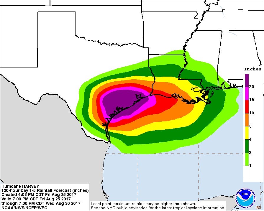
A Year’s Worth of Rainfall in a Few Days?
South-eastern Texas will likely receive upwards of 24 inches (61 centimeters) of rainfall, with certain locations potentially accumulating over 36 inches. Some forecasters predict localized rainfall totals of up to 40 inches. Contrast this with Corpus Christi’s average annual rainfall of about 32 inches.
A 1-in-100 Precipitation for Houston?
RMS estimates Harvey’s precipitation extremes have a return period of 100 years in Houston. In other words, the rainfall anticipated over Houston has a one percent chance of occurring there in any year. The annual likelihood for Corpus Christi’s expected precipitation from Harvey is 0.3%, or 1-in-350. Of course, a 1-in-350 rainfall level does not necessarily lead to a 1-in-350 loss. However, such extremes over such a broad area create the potential for widespread catastrophic flooding.
More Flood Protection in Rockport and Corpus Christi than Houston?
Flood losses in some of the worst hit coastal areas could be largely protected by the National Flood Insurance Program (NFIP). Aransas County (Rockport) shows a NFIP penetration rate for “high risk” areas of 88 percent. Over two-thirds of high risk areas in Nueces County (Corpus Christi) appear covered by NFIP. Elsewhere, though, the picture is more concerning for homeowners. Only 28 per cent of high risk locations in Harris County have NFIP policies. Worrying as Harvey continues to track northeast.
Harvey Is No Ike?
Harvey has been intense, but remains relatively compact. Our analyses estimated an Integrated Kinetic Energy of 27 terajoule (Tj) at landfall. Compare this with 140Tj for Hurricane Ike and you get a sense of the difference in scale. Ike had five times the energy of Harvey.
It’s Raining Like Allison?
But Ike didn’t stall over the coastline and dump a year’s worth of rainfall in a matter of days. Every storm is different. Harvey’s legacy will likely be eclipsing Tropical Storm Alison’s torrential rain, and thereby causing one of the largest floods ever seen.
Tornado Risk Persists?
Tornadoes will exacerbate the situation in southeast Texas into Tuesday. Harvey is still drawing moisture onshore and remains nearly stationary over the region. The threat of a dozen tornadoes is not likely to worry insurers in the overall scheme of a “brown ocean” Cat 4. It does, however, endanger life and complicates emergency response.
Parametric Cover for NFIP Could Have Triggered by Now?
NFIP needs reform. The premiums paid by homeowners simply don’t cover the cost of the claims paid out. That’s why the program is $23 billion in debt to the U.S. Treasury. And that’s also why FEMA syndicated $1 billion of flood risk to the private reinsurance markets earlier this year. It’s not improbable that Harvey will produce at least $4 billion in flood claims, triggering the NFIP reinsurance program. It’s too early to tell whether NFIP should have retained more or less risk. What is clear, however, is that protection could have been triggered already had NFIP felt empowered by Congress to use a parametric structure to cover itself.
High “Leakage” Potential?
The combination of wind, rain and surge may make it difficult for adjusters to clearly identify the causes of a given loss. This heightens the potential for uninsured water damage to be paid by wind-only policies. Unable to distinguish loss source, insurers will need to account for inadvertently picking up some flood claims under wind policies.
Test Case for the “Disaster Deductible”?
FEMA is considering a deductible concept, requiring each state to take responsibility for a predetermined amount of its disaster costs before federal assistance kicks in. Governor Abbott declared state of disaster before Harvey made landfall and President Trump responded. What this means for the FEMA deducible that’s on the table, however, remains unclear.
Offshore Energy Relatively Unscathed?
Analysis of our offshore platform data reveals that roughly 10% of Gulf of Mexico Offshore energy assets could have been affected by Harvey. That equates to more than $20 Billion in rigs, platforms, wells, pipelines. The degree of damage will take some time to emerge as structures can only be surveyed once the danger passes. Again, though, a track further round the coast would have hit many more platforms, as Ike did.
Onshore Risk Greater?
Water, not wind, might end up driving industrial losses. It could take 18 to 36 months for onshore refineries to return to full production capacity if they sustain just two feet of flooding, suggests the Bay Area Houston Economic Partnership. A distinct possibility given levels of rainfall being forecast.
Coastal Industry’s Losses May Trouble Reinsurers?
The Texas coastline has numerous industrial facilities which could have experienced both wind and surge damage. These losses may well flow through facultative policies into the reinsurance market generally and Lloyd’s specifically. RMS is carefully studying our databases of industrial facilities alongside reconnaissance imagery to better assess the likely impacts.
Jeff Waters, product manager – Model Product Management, RMS
As Harvey continues to meander over southeastern Texas, pumping band after band of moisture onshore, many cities and towns are braced for what could be the worst flood event in the state’s history. Multiple computer models continue to forecast widespread rainfall totals of between 10 to 30 inches (25 to 76 centimeters), with localized areas expected to see up to 40 inches (101 centimeters).
Of particular concern is the Houston metropolitan area, which is no stranger to significant flood events (see Tropical Storm Allison – 2001, 2016 Texas floods). As of early Sunday, the city had already received upwards of two feet (61 centimeters) of rain, triggering widespread flooding which is only expected to worsen over the coming days. Compounding the water-driven effects in this region is the potential for Harvey’s high storm surge levels to prevent rivers from properly draining rainwater into the bay, creating a confluence of water within and around the city, including the Houston Ship Channel.
Exacerbating the situation further is the ongoing threat of severe weather – notably tornadoes – driven by Harvey’s counterclockwise rotation and relentless movement of moisture and convection onshore. On Saturday, August 26, there were 12 preliminary tornado reports in southeast Texas. That threat is expected to continue into Tuesday as Harvey remains nearly stationary over the region.
How will all this impact the (re)insurance industry? This remains to be seen, as there are numerous factors still at play. During a live Q&A session on Twitter yesterday, we explained how the combination of high winds and storm surge could make it difficult for claims adjusters to determine the cause of loss for damaged properties. As a result, “coverage leakage”, where water-driven losses are sometimes paid under wind-only policies due to the inability to distinguish loss sources, may become a key factor in this event. It is also important to monitor National Flood Insurance Program (NFIP) participation, especially given the newly established $1 billion reinsurance program. However, it is worth noting that NFIP take-up rates are low in southeast Texas, increasing the likelihood of material uninsured losses.
It is obvious that there is no shortage of factors and impacts to monitor in the coming days. During this time, RMS will continue to keep you informed of new information as it becomes known.
Pete Dailey, vice president – Product Management, RMS
Harvey Likely to Hit NFIP With High Volume of Claims
While some residents living along the Texas shoreline begin to recover from the intense winds and storm surge from Hurricane Harvey, those located inland are still in harm’s way. Harvey has stalled over southeastern Texas, and forecasters at the National Hurricane Center (NHC) continue to predict that some locations will receive upwards of 24 inches (61 centimeters) of rain. Many inland locations will receive their typical annual rainfall within just a few days, a situation likely to cause widespread and catastrophic flooding.
This event comes at a tumultuous time for the nation’s top provider of flood insurance, the National Flood Insurance Program (NFIP). Heading into this year’s hurricane season, the NFIP carries significant debt, which exceeds $20 billion largely due to claims following Hurricane Katrina (2005) and Sandy (2012). This presents a major challenge for U.S. legislators returning from their summer recess as the NFIP will expire on September 30, unless Congress appropriates additional funding.
For private flood insurance, the market is relatively small and offers limited policy choices outside of NFIP. Many homeowners are also simply unaware of their flood risk and, if they live outside a high-risk flood zone, may not realize they lack flood coverage on standard wind policies.
To better manage its risk and partially protect itself from massive flood losses, FEMA (which manages the NFIP) announced in January that 25 reinsurers would cover 26 percent of losses exceeding $4 billion up to a limit of $8 billion. So, for a major event that produces $8 billion in flood claims, reinsurers will cover just over $1 billion of the loss. This risk transfer is critical to managing the NFIP given its current debt load and borrowing limits.
Is it possible that Harvey will produce at least $4 billion in flood claims and trigger the NFIP reinsurance program? That remains to be seen, but it does appear the likelihood is quite high. For some historical perspective, Hurricane Katrina resulted in $16.3 billion in NFIP claims, and Hurricane Sandy resulted in $8.3 billion. Katrina was a major hurricane at landfall as was Harvey, but significantly larger in size. Much of Katrina’s flood loss was related to levy failure. Sandy was not a major hurricane at landfall, but given its extra-tropical characteristics it dropped heavy rainfall combined with severe coastal surge in the highly exposed Northeast Corridor.
Will the level of NFIP claims from Hurricane Harvey see a repeat of Katrina or Sandy? While Harvey is not as large as Katrina, and is not positioned over the dense exposure of the Northeast as with Sandy, here are four points why it is perhaps the “perfect storm” from a flood risk point of view.
First, Harvey spent considerable time over the Gulf of Mexico as it strengthened and grew, capturing a tremendous amount of moisture. Second, the late-summer jet stream is displaced to the north, allowing Harvey to stall in the absence of steering currents, and drop heavy rain for an extended period. Third, the storm’s slow and meandering track has further extended the time it has had to accumulate moisture. Lastly, the alignment of thunderstorm cells with Harvey’s low-level airflow are producing a phenomenon called “cell-training” in which successive cells of torrential rain relentlessly impact a location.
It will be some time before Harvey stops dropping flooding rains, and homeowners and adjusters begin assessing the damage. Once claims begin to flow into the NFIP, a clearer picture of the total loss will follow. What we do know today is that Harvey has the potential to cause catastrophic flooding across a large portion of Texas. As the NFIP comes up for reinstatement in October, and the reinsurance program comes up for renewal in January, Hurricane Harvey will clearly be a pivotal topic in the debate over the future of the NFIP.
As of today, Sunday August 27, the official NHC forecast shows Harvey moving southeastward and re-emerging over the Gulf, picking up additional moisture, then slowly meandering northward over eastern Texas. This could mean several more days of heavy rainfall over already flooded communities. RMS will continue to provide updates as the story develops.
Mark Powell, vice president – Model Development, RMS HWind
The RMS-HWind team have been conducting continuous 24/7 monitoring of Hurricane Harvey, and are monitoring a weather system that is expected to develop into a new tropical depression off the coast of Georgia.
As long as a storm maintains sustained tropical storm winds over 39 mph (62 kilometers per hour), which can contain damaging gusts as well as force storm surge, RMS-HWind will release a set of products documenting the wind field, and despite Harvey being inland for a day and a half, tropical storm winds continue along the coast and inland. For this new system off the Georgia coast that we are watching, known as Invest 92L, buoy and satellite measurements indicate gale force winds are present but the circulation center is being affected by wind shear and is not yet close enough to deep clouds for a tropical system to develop.
Harvey will continue its slow motion and may emerge back over the Gulf of Mexico on Tuesday so it is expected to maintain itself as a Tropical Storm with no significant motion inland until Wednesday.
Harvey is shaping up as a catastrophic rain flooding event, with water rescues going on all around the Houston metro area. The NOAA Weather Prediction Center reports rainfall totals exceeding 24 inches (61 centimeters) in some locations. These conditions are forecast to persist for several days with another 18-24 inches of rain possible in southeast Texas. Spiral rainbands continue to move in from the Gulf exacerbating the flooding and adding an additional threat from tornadoes.
RMS hurricane risk expert, Tom Sabbatelli, interviewed on BBC News after Hurricane Harvey makes landfall in Texas
Update at 23:30 UTC
Tom Sabbatelli, hurricane risk expert, RMS
With maximum sustained winds of 130 mph (209 kilometers per hour), Hurricane Harvey made landfall near Port O’Connor, Texas overnight as a Category 4 storm. Our industry knew it was only a matter of time before the prolonged U.S. major hurricane landfalls would end, although just days ago few would have anticipated Harvey to be the storm to end it.
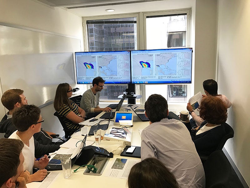
It’s “all hands on deck” this Saturday for the RMS Event Response team, pouring over the latest wind, storm surge, and rainfall reports. Today’s goal is to build upon yesterday’s pre-landfall stochastic event selection. Harvey adds an extra layer of complexity, with a uniquely slow and meandering forecast track along the coast. Past hurricanes have traversed on paths straight through Texas, extending swaths of damaging winds much further inland.
This complexity increases the sensitivity required in event selection, as events with longer wind footprints could cause damage in heavily populated metropolitan areas, such as San Antonio, expected to be spared by Harvey’s worst. With careful filtering of track and event parameters, the team has isolated stochastic events closely resembling the latest forecasts, including tracks that stall along the coastline and even loop back around towards the east.
As yesterday’s stochastic event selection already considered a number of major hurricane landfall scenarios, today’s updated selection does not significantly alter the range of industry losses associated with the scenarios. At this time, industry guidance continues to suggest insured losses in the low, single-digit billions, with some higher end estimates becoming less likely.
However, it will still be several days of analysis and reconnaissance until the full impact on our industry becomes clearer. What’s assured at this point is that economic damages from Harvey will dwarf insured losses. Catastrophic amounts of rain have fallen just within the first 12 hours of Harvey’s landfall, with similar rainfall rates expected for several more days. We continue to monitor the latest developments as the RMS Event Response team executes its real-time hurricane processes through the weekend and the week ahead.
Michael Kozar, senior modeler – Model Development, RMS
Hurricane Harvey made landfall last night on the Texas coastline at approximately 03:00 UTC with estimated maximum sustained winds of 130 mph (209 kilometers per hour) based on measurements from the Air Force Reserve Hurricane Hunters. Harvey was an intense but relatively compact storm at landfall, with hurricane force winds not extending much further than 40 miles from center. Our HWind analyses estimated that Harvey had 27 terajoule (TJ) of integrated kinetic energy at landfall. Compared to recent storms that affected Texas, Harvey had stronger peak winds, but less overall kinetic energy than Hurricanes Ike and Rita, both of which were larger storms with more than twice the integrated kinetic energy in their wind fields. In fact, Hurricane Ike contained more than 140 TJ at one point prior to its landfall in 2008.
Since landfall, Harvey’s peak winds have fallen off, but at 1200UTC, nine hours after landfall, Harvey was still a hurricane. Harvey’s structure has remained remarkably well in tact over Texas, and an eye was clearly visible on satellite past 1100UTC. Radar continues to indicate that Harvey is maintaining a tightly wound central core, with intense rain bands stretching into the Houston and Galveston area.
As expected, Harvey’s forward motion has slowed considerably since yesterday. The storm is still drifting to the NNW, but as the steering flow continues to collapse, Harvey will likely meander over eastern Texas well into next week. The potential exists that Harvey could reemerge briefly over the Gulf of Mexico next week, making a second landfall as a much weaker storm on the Texas coastline. Regardless, tropical storm force winds will likely continue for the next few days, and torrential rainfall will persist long after that.
Widespread flooding is expected across much of eastern Texas over the next several days. Rainfall amounts in Galveston already have exceeded 2.5 inches based on National Weather Service gauge data. Further to the southwest, where the center of Hurricane Harvey came ashore, Texas Mesonet stations have measured more than 8 inches of rain, and National Weather Service radar suggests precipitation totals already may have exceeded one foot in some regions. By the time Harvey finally dissipates, more than two to three feet of rain will likely fall, with some localized areas potentially reaching 40 inches of total precipitation.
Hurricane Harvey has made landfall and is the most powerful hurricane to make landfall in mainland U.S. in a decade. This region is also critical for the country’s oil and gas industry, home to key refineries and the fourth largest port in the U.S. (Corpus Christi). While the storm continues to pose a significant threat to people and onshore properties in the next few days, the oil and gas industry is nervously awaiting news on how their offshore assets fared in the storm’s wake.
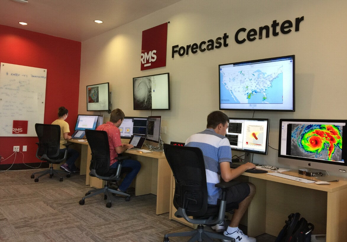
Analysis of the RMS Offshore Platform Exposure database reveals that roughly 10 percent of Gulf of Mexico Offshore energy assets, valued at more than $20 billion, including drilling rigs, oil and gas platforms, wells, pipelines, etc., could be affected by Hurricane Harvey if it indeed followed the National Hurricane Center’s forecast predictions.
What could be the worst-case scenario? For comparison, Hurricane Ike in 2008 tracked a path parallel to Harvey 200 miles north as a Category 1 storm. It destroyed more than 100 platforms and rigs, collapsed 250 oil and gas wells, and led to more than $6 billion in offshore energy losses.
While most of the offshore energy exposure is farther away from Harvey’s predicted area of highest winds, damage to offshore infrastructure is driven primarily by waves. So even platforms far away from the storm’s track can be adversely impacted by damaging waves. The magnitude of wave impacts depends on the water depth at the platform’s location, with the highest impacts often observed in the “hot zone” – shallower water depths of 200 to 400 feet on the right side of the storm track. In Harvey’s case, the hot zone borders an area rich in offshore platforms. So, it all depends on how long the storm stalls before making landfall and if it is long enough to generate high waves in the Gulf.
Pete Dailey, vice president – Product Management, RMS
Harvey to Deliver Massive Rainfall
As Hurricane Harvey races towards Corpus Christi, Texas, it provides an important reminder of the wide range of hazards embedded within a tropical cyclone. While it appears that the hurricane will make U.S. landfall with the strongest winds in over a decade, an equally compelling story will be told by the precipitation left behind by this storm.
Forecasters predict that portions of southeastern Texas will receive upwards of 24 inches (61 centimeters) of rainfall, with some locations potentially accumulating over 36”. Contrast this with Corpus Christi’s average annual rainfall of about 32” – Harvey could produce a year’s worth of rainfall in just a few days! This poses widespread potential for catastrophic flooding. RMS estimates the precipitation extremes in Harvey have a return period of 350 years (annual likelihood of 0.3%) in Corpus Christi and 100 years (annual likelihood of 1%) in Houston[1].
[1] Note, a 100-year precipitation event does not necessarily translate into a 100-year flood loss event. Due to the complexities of river networks, floodplain topography, soil conditions, and many other factors, the estimation of flood loss requires sophisticated hydrodynamic modeling and massive computing resources.
Michael Young, Head of Americas Climate Model Product Management, RMS
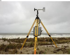
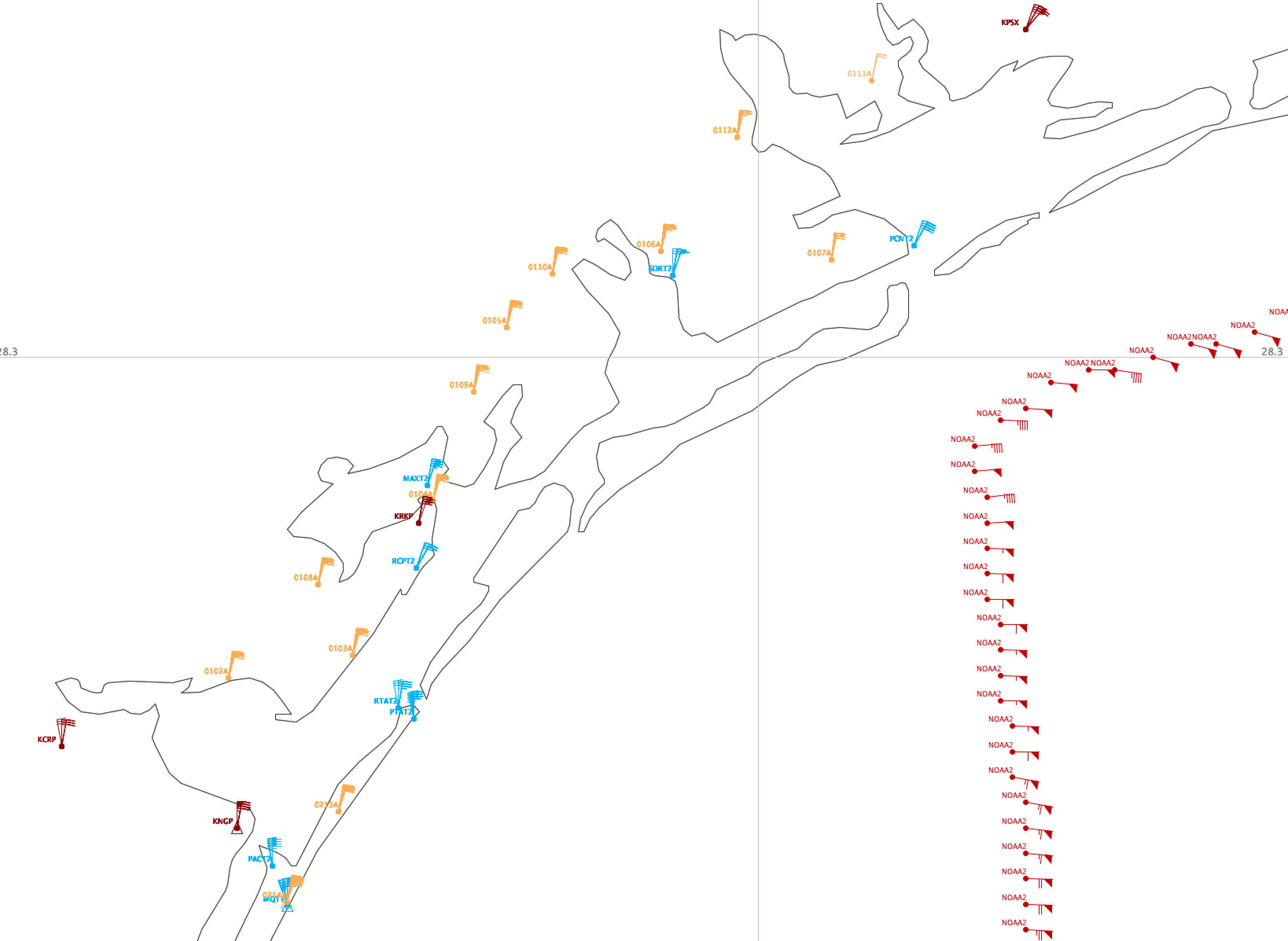
Collecting Real Time Field Data
One of the challenges that we always face in hurricane event response is having enough wind observations to create a complete picture of the windfield to use in our modeling activities. This year, we are happy to announce that HWind is now ingesting data feeds from the Texas Tech Hurricane Research Team (TTHRT) Sticknet platform. Texas Tech University has a set of 24 mobile anemometer data units that can be rapidly deployed in advance of a storm. Led by Dr. John Schroeder, professor at the National Wind Institute, a team to graduate students and laboratory staff figure out where the storm is headed and drop an array of these instruments in advance of the storm making landfall
There is definitely an art to this kind of real-time deployment, and I have a lot of respect for these researchers. As seen in this figure from our HWind QC application, the TTHRT team has now successfully deployed 14 Sticknet instruments (yellow flags) between Corpus Christi and Port O’Connor which are already starting to register gust wind speeds of 60 mph as of 4 pm CDT August 25 – still hours prior to landfall. These instruments are going to be very useful in capturing the peak wind speed at landfall.
The TTHRT team has now retreated back to Corpus Christi to ride out the storm. Stay safe – guys!
Michael Kozar, senior modeler – Model Development, RMS
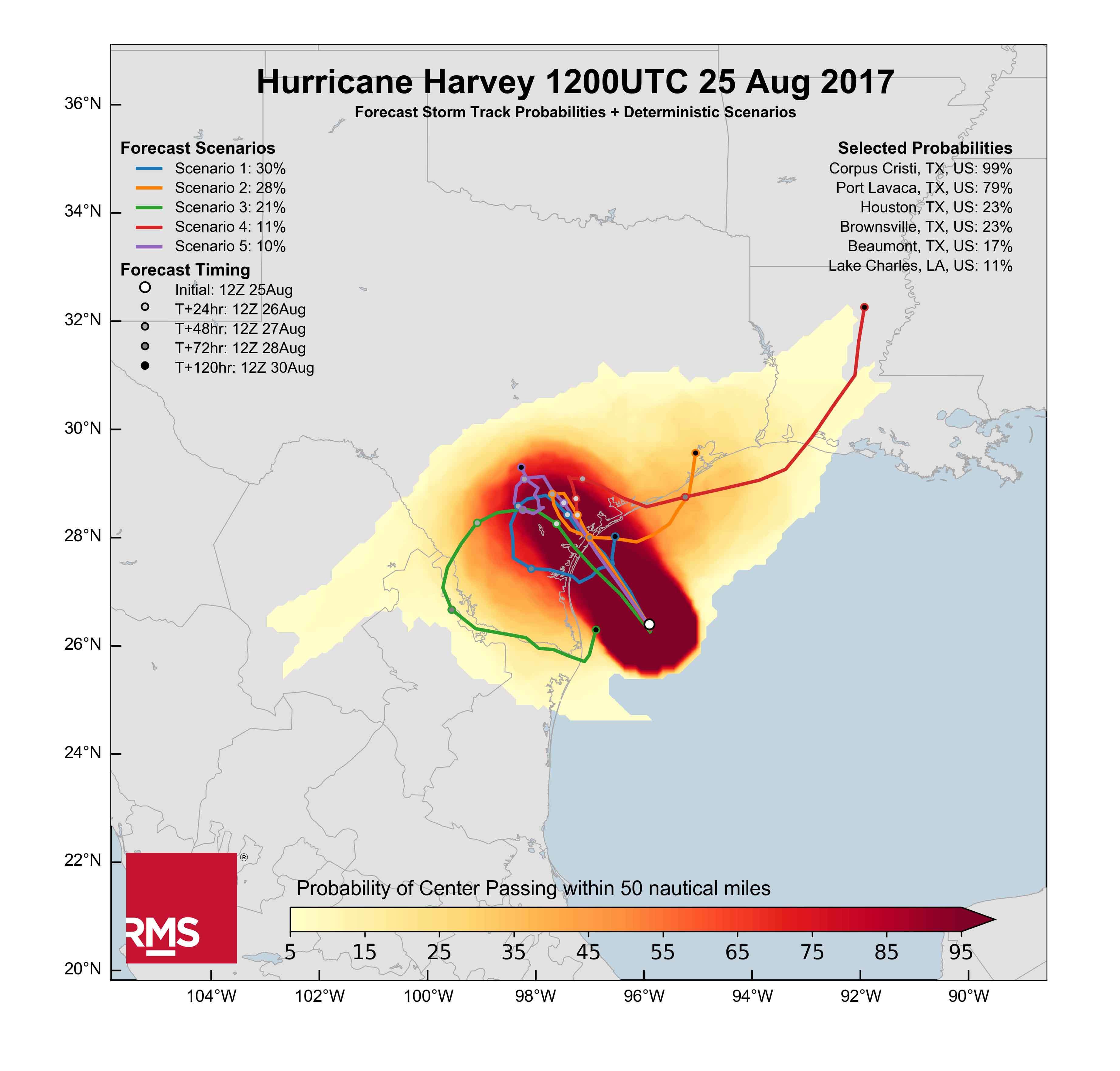
The new RMS HWind forecast track product helps clients visualize the forecast uncertainty of an ongoing tropical cyclone.
In this example shown above, the shaded field shows the probability of the center of Hurricane Harvey being within 50 nautical miles of a certain position based on a large array of available forecast models. To complement the gridded cloud of probabilities, we also extract selected probabilities at selected population centers in a table at the top of the plot.
Finally, overlaid on top of the shaded probabilities, we present five specific track scenarios for Harvey that are representative of the underlying models. These five scenarios have their own probabilities and each scenario provides important timing information across the probability cloud so clients can have an estimate of when hazards may occur.
Michael Kozar, senior modeler – Model Development, RMS
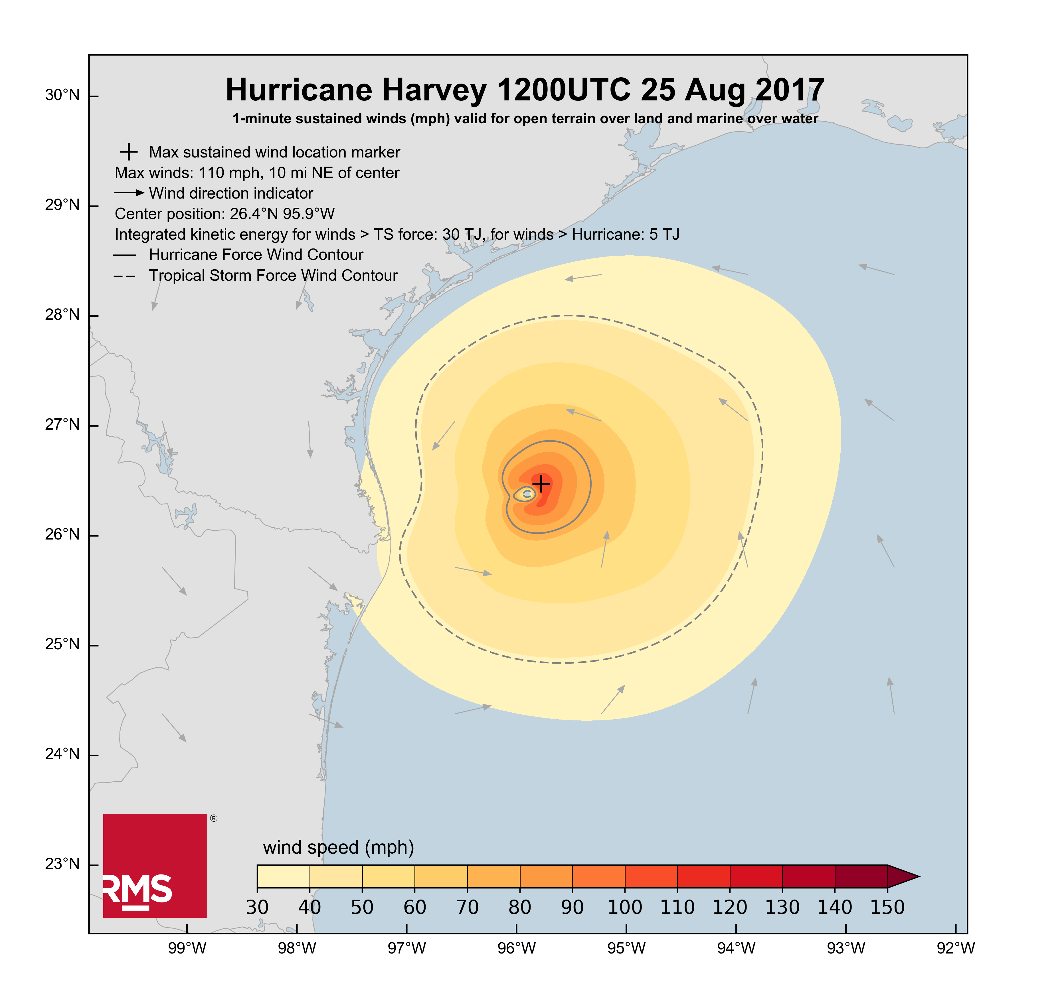
The RMS HWind team in Tallahassee, Florida continues to monitor Hurricane Harvey as it approaches the Texas coast this morning. At 12:00 UTC or 7 a.m. CDT, Hurricane Harvey had peak sustained winds of 110 mph (177 kilometers per hour) based on Stepped Frequency Microwave Radiometer (SFMR) observations aboard the Air Force Reserve Hurricane Hunters. Tropical storm force winds are just reaching the Texas coastline now, and wind speeds will only continue to increase as Harvey closes in.
Hurricane Harvey began to rapidly intensify from a disorganized tropical storm on Thursday morning, achieving hurricane status that same afternoon. Intensification slowed Thursday evening as a secondary eyewall formed. However, that respite was short-lived as Harvey’s maximum sustained winds increased by nearly 30 mph (48 kilometers per hour) overnight.
Intensification is expected to continue in the immediate future as Harvey continues to move through a favorable environment with warm ocean temperatures and low vertical wind shear. In fact, the latest satellite images show warming cloud tops near the center of Harvey, indicating that an eye is beginning to clear out.
Harvey is expected to continue on a somewhat slow northwest heading, with landfall expected near Corpus Christi later tonight. After making landfall, Harvey is expected to slow to a near halt, as steering currents weaken. This nearly stationary position along the Texas coast will keep Harvey from moving very far inland and will enable the storm to maintain itself longer than most hurricanes after landfall. As such, Harvey will continue to produce damaging winds and extreme rainfall over eastern Texas after its initial landfall. Rainfall amounts, which likely will exceed one to two feet in some regions, coupled with storm surge will likely produce significant flooding damage both at the coast and further inland over the next several days.
As Harvey continues its march towards Texas, the RMS HWind team will continue to monitor the storm, taking in valuable observations from surface stations and aircraft reconnaissance to provide clients real-time wind information at least every three hours.
Ben Brookes, vice president – Capital Markets Solutions, RMS
Until yesterday evening, Harvey looked like a rain-flooding threat, largely likely to landfall as a tropical storm or weak category 1 hurricane. With its potential to stall over the coastline, that scenario could have been dangerous, particularly for those local communities with significant flood risk.
The situation now looks more concerning: Harvey could become the first major hurricane to make landfall in the U.S. since Wilma in 2005, some 12 years ago. This would add wind and storm surge threat to the rainfall-driven flood risk we were already worried about.
These are the moments we try our best to prepare for. The well-oiled RMS machinery moves into action as the Event Response and hurricane modeling teams keep a close eye on the forecasts, and we try to pull together the best possible insights for our clients.
Our first meeting to select possible storm tracks starts early. This is where we review the modeled storms selected by our scientists, to see which might be the best representations of how Harvey could play out.
At this stage, we’re looking at wind damage only.
There’s a buzz in the air – with a near miss last year, Hurricane Matthew reminded us what it felt like to go into full event response mode. Now we’re back together again, unusually early in the season for a possible major hurricane.
There is a sense of growing meteorological intrigue, coupled with the concern that lives and livelihoods are at risk thousands of miles away. I hope the local communities are prepared and are getting to safety. A lucky streak of no major hurricanes in over a decade also means the memory of the threat has probably faded in those areas. We hope not.
We discuss the exposure on the ground – it looks like Harvey is bearing down on areas of less dense exposure, and we note that unlike Matthew, a shift left or right from the current track won’t change that dramatically. But the big exception is Corpus Christi and the smaller towns along the coast which may be vulnerable to potential storm surge as well as wind. Our analysis also suggests industrial clusters in the region could face wind and flood damage.
We close the meeting hoping this is another dodged bullet for our industry. Our selection of scenarios suggests something in the low single-digit billions is most likely from wind damage. Low-attaching industry loss warranties could be at risk if the situation worsens dramatically, but that’s not the most likely outcome. What are the chances of that? Not high. Looking at the loss distributions based on this this morning’s event selection, using National Hurricane Center forecasts, we estimate there’s only a 10 percent chance that wind loss could exceed U.S. $6 billion. Although it probably won’t happen – it’s possible, clearly.
But look at the bigger picture. Our selection of possible Harvey wind scenarios contains much less damaging storm developments, including those with industry losses of less than $1 billion.
The RMS Capital Markets team have been busy looking into the potential impact on the cat bond market – at the moment we have our eyes on FONDEN, with its parametric trigger extending from Mexico up the Texan coastline. If the central pressure of the storm drops significantly and it hits the box, that deal could be at risk. Likewise, we note a Res Re class with elevated attachment probability – albeit only slightly. Interestingly, at this point we don’t see the Alamo deals looking at risk. The relatively high attachment points might explain that. The situation will become clearer as the event unfolds, of course.
As the hurricane develops, our updates should give more insight on storm surge and inland flooding, which could be the dominant drivers.
At 01:00 ET, Hurricane Harvey is now officially a Cat 2, with sustained winds of 100 mph and central pressure continuing to drop, now down to 967 millibars.
Satellite Imagery Showing Better Organization of Cat 1 Hurricane Harvey
As an official RMS client advocate and Meteorologist, and an unofficial extension to the RMS Event Response team, I sit at home in New Jersey having just reviewed the 11 p.m. ET (24 Aug) National Hurricane Center’s official update, which holds the wind steady at 85 miles per hour, pressure at 973 millibars; however the satellite imagery is showing some better organization of Cat 1 Hurricane Harvey…do I sleep tonight?
The next NHC advisory is at 5 a.m. ET, and I’ll be awake (did I sleep?) to see where the storm is headed, but more importantly, how has Harvey strengthened in the last 6 hours, ready to discuss with the RMS Event Response team by 5:30 a.m. ET about what is the official course of action and key deliverables RMS will communicate in just a few hours time to our eager client base.
We all had a bit of a practice run with Hurricane Matthew (2016). Harvey definitely has our collective consciousness and we are deeply focused to help our clients.
Hurricane Matthew has tracked most of the way up the Florida coastline as a Category 3 major hurricane. Matthew tracked further offshore than previously forecast, placing the worst of the storm’s winds and storm surge offshore of Florida. While there have been hurricane force winds onshore and some damage from Matthew along portions of Florida’s east coast, thankfully the levels of damage in Florida that we are seeing are lower and less widespread than we expected just 24 hours ago.
As Matthew continues to track along the coastline, our focus shifts north towards Georgia and South Carolina, with a potential landfall near Charleston, South Carolina as a Category 2 hurricane. Even if landfall does not occur, there is significant flood risk in the southeast U.S., including high storm surge risk from Jacksonville northward to Charleston, SC. As a large, slow moving storm, Matthew has been absorbing a lot of tropical moisture and building up a lot of rising water over its lifecycle. This increases the potential for heavy rainfall and significant build-up of water along the southeast coastline, which features greater storm surge potential than eastern Florida due to local bathymetry. The magnitude and extent of storm surge-driven coastal flooding, exacerbated by the occurrence of astronomical high tide cycles, is expected to rival that of Hurricane Hugo (1989).
Bands of heavy rain are extending as much as 500 miles north-northeast of Matthew into Georgia and the Carolinas, suggesting that the storm could cause excessive rainfall and precipitation-induced flooding over the next few days. Rainfall estimates in excess of one foot (30 cm) are expected along the coast of South and North Carolina, two areas where soils are already heavily saturated and river levels are high based on significant rainfall over the last few weeks. According to the National Weather Service in Charleston, South Carolina, coastal and inland flooding impacts could be comparable or worse than the October 2015 flood event.
A shift in Matthew’s movement could have a large influence on the impacts both along the coast and further inland.
Over the past several days, Matthew’s forecast has changed significantly.
To assist our clients in understanding the full range of potential outcomes from Matthew, we continue to select stochastic events from our North Atlantic Hurricane model to represent the range of potential scenarios as the situation evolves. These have been provided to our clients on a daily basis, along with information regarding the modeled losses of these scenarios from our Industry Loss Curves. As the forecasts have evolved, so have the events we selected to represent the range of scenarios. As would be expected with a shift in forecast away from the Florida coast over the past 24 hours, today’s event selection saw a significant reduction in losses.
As a measure of the change in just 24 hours, the average industry loss of the 15 selected events yesterday was $20bn, with losses from the individual scenarios ranging from $7bn to $54bn. Today, the average loss of the 10 selected events was just $6bn, with losses from the individual scenarios ranging from less than $1bn to $19bn. This illustrates that the range of potential outcomes has shifted significantly, but it still remains wide – and continues to evolve.
But these are just modeled scenarios, chosen based on track parameters that are already out of date.
Just as the average loss from the range of scenarios doesn’t mean much, individual scenario losses shouldn’t be viewed as loss estimates for Matthew: they are chosen to help our clients make sense of what’s happening. Tomorrow these will change yet again as the official forecasts are updated and our understanding of the storm evolves.
Efforts towards determining RMS’ official loss estimate for a hurricane begin once the storm has fully passed.
This is when our modelers can begin producing reconstructions of the hurricane’s windfield and storm surge extent. In significant hurricane events, such as Matthew, RMS modelers and experts are also deployed to survey damage on the ground. Matthew’s ultimate behavior, including a possible recurvature towards The Bahamas and Florida next week, could potentially delay these efforts.
In the meantime, as Matthew is still evolving, so is our response.
The RMS Event Response team will continue to provide daily event reports with updates to the stochastic event selections daily through the weekend. The RMS Knowledge Center will also be on hand through the weekend should any questions arise.
Let’s see what tomorrow brings.
This post was co-authored by Emily Paterson, Tom Sabbatelli, Ben Brookes, and Paul Wilson.…
Emily Paterson is a senior manager in Model Product Management at RMS, where she leads the RMS Event Response Service, which responds to real-time catastrophe events around the world, providing products and tools for clients to assess the impact of an event. Since joining the event response team at the end of 2010, Emily has coordinated the RMS response to many significant events, including the Tohoku Earthquake and Tsunami in 2011 and Hurricane Sandy in 2012. Emily joined RMS in 2007, working in the Asia Pacific and Europe teams on model product management prior to joining the event response team. Emily holds a B.Sc. in Statistics from the University of Western Ontario and a M.Sc. in Disaster Management and Sustainable Development from Northumbria University.