The midway point of the Atlantic hurricane season has just passed, and despite a relatively tame start, we have already witnessed two major U.S. hurricane landfalls — Harvey and Irma — in quick succession. It is the first calendar year on record where two hurricanes of Category 4 strength or greater have made landfall in the contiguous U.S. To add insult to injury, Maria has quickly intensified and is expected to be the fourth major hurricane of the season as it tracks through the Leeward Islands, an area left devastated by Irma less than two weeks ago.
With 13 named storms, seven hurricanes, and three major hurricanes, we have already met the National Oceanic and Atmospheric Administration (NOAA) definition of an above-average full Atlantic hurricane season. It is understandable that many in the insurance industry may be suffering from “hurricane fatigue” well before the calendar flips over to October.
But we should not be too surprised by this year’s activity. In August, NOAA elevated its 2017 hurricane season forecast originally issued in May, warning that this season had the potential to be extremely active. Several other seasonal forecasting agencies, such as Colorado State University and Tropical Storm Risk, also increased their May outlook reports during early August to call for a more active season.
It appears that these forecasts of an above-average season are increasingly being validated, with favorable conditions set to continue. With these forecasts in mind, what does the remainder of the 2017 hurricane season have in store?
Increased Chance of a Late Season La Niña
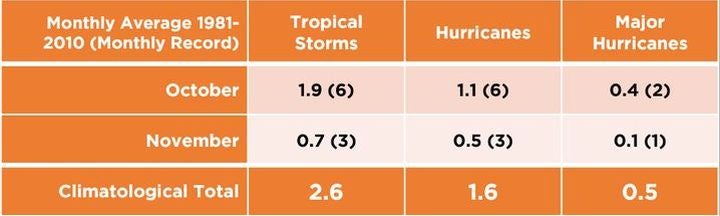
From October 1, hurricane activity tends to reduce, with an average of two to three named storms occurring before the official end of the season on November 30.
Table 1. October and November Atlantic hurricane climatology. Source: NOAA National Centers for Environmental Information, State of the Climate
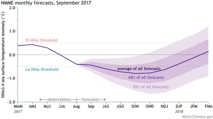
However, the latest forecasts suggest we might see an active end to the season due to the influence of one of the primary drivers of seasonal activity in the Atlantic — the El Niño-Southern Oscillation (ENSO). My colleague, Christopher Allen, recently provided a detailed overview of the discovery and dynamics of ENSO, the planet’s largest source of natural climate variability.
ENSO remains in a neutral state at present, but equatorial sea surface temperatures in the central and eastern Pacific have been observed to be slightly below average during the last month. Similarly, sub-surface temperature anomalies have become increasingly negative in recent months. These cooler temperatures may signal cool-neutral or La Niña ENSO conditions in the coming months, favoring decreased Atlantic wind shear and offering a healthy environment for basin cyclogenesis.
Operational ENSO guidance favors cool-neutral conditions through the fall, but some models predict the formation of La Niña. In response, the Climate Prediction Center issued a La Niña Watch, indicating an increased chance of La Niña formation in the near term.
Figure 1. Summary of ENSO forecasts issued in September 2017. Source: NOAA
Although other climate signals can drive hurricane variability, historical late season cool-neutral ENSO phases have produced above-average activity in the latter months of the season. Weak La Niña conditions observed at the end of last season contributed to the formation of three major hurricanes in October and November.
A look back at recent records shows that October and November can produce some notable landfalling Atlantic hurricanes, including:
Hurricane Opal made landfall in the Florida Panhandle on October 4, 1995 as a Category 3 storm, causing significant wind and storm surge damage. At the time, it was the third most-costly hurricane to the hit the U.S.
Hurricane Sandy, the final hurricane of the 2012 season, transitioned to an extra-tropical cyclone in the hour prior to its landfall along the coast of southern New Jersey on October 29.
Hurricane Matthew, the most intense storm of the 2016 season, tracked offshore parallel to the eastern Florida coast as a Category 3 hurricane before making landfall in South Carolina on October 8 as a Category 1 storm. Prior to approaching the U.S., Matthew caused significant damage and loss of life in Haiti, Cuba, and the Bahamas.
Activity in the latter months of the season tends to shift from the eastern Atlantic to the Gulf of Mexico and the Caribbean Sea. On the surface, this could increase the potential of developing storms to impact land; however, individual storm tracks are highly sensitive to the location of cyclogenesis and local atmospheric and oceanic conditions, so they cannot be forecast reliably more than a several days in advance. Even with this uncertainty in mind, the latest ENSO forecasts will keep all eyes focused on the Atlantic, as everyone is keen to know whether this “hurricane fatigue” will continue.
Share:
You May Also Like
March 20, 2024
Moody’s RMS 2023 Catastrophe Review: Secondary Perils Headline Again
Based in London, James works as a Senior Modeler within the RMS Event Response team, supporting real-time event response operations and assisting on various event response projects. James holds a bachelor’s degree in Physical Geography and Geology from the University of Southampton and a master’s degree in Applied Meteorology from the University of Reading.