Irma: Westward Forecast Shift Creates Déjà Vu With Matthew
Tom Sabbatelli-GoodyerSeptember 09, 2017
15:00 UTC Saturday, September 9
Tom Sabbatelli, hurricane risk expert – RMS
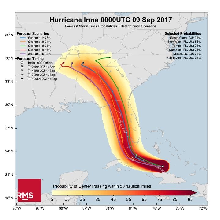
The westward-moving trend of recent Hurricane Irma forecasts continues, with the Florida Keys, southwest Florida, and Tampa potentially within Irma’s sights. Although the National Hurricane Center forecast “cone of uncertainty” still covers much of south Florida, 83 percent of the individual forecasts analyzed by the RMS HWind forecast product bring the hurricane within 50 nautical miles of Key West, indicating that the Miami metropolitan region may be spared the worst of Irma’s winds. 75 percent of these forecasts also indicate a passage within 50 nautical miles of Tampa (see “Selected Probabilities” in the figure below).
Figure 1. RMS HWind Forecast for Hurricane Irma, as of 00:00 UTC on September 9, 2017. Impact probabilities (upper right) represent the probability of the storm’s center passing within 50 nautical miles of each city.
Based on today’s forecast, RMS calculates there is a 10 percent chance of wind losses from Irma exceeding US$70 billion. This 10 percent exceedance threshold is less than the same threshold published yesterday (Friday), reflecting the storm’s movement away from south Florida’s most highly-concentrated regions. However, this threshold remains high: while the focus may have shifted from Miami, a direct landfall in the Tampa Bay region very much remains a possibility.
An increased likelihood of impact along the Gulf coast of Florida also increases the likelihood of more severe storm surge losses. The offshore bathymetry of Florida’s west coast features a shallower slope than that of the east coast, making it more susceptible to storm surge buildup, as Robert-Muir Wood has stated previously on this blog. Our stochastic event selection follows suit; although today’s events are selected on the basis of expected wind impacts, some of these events feature high levels of storm surge inundation along the southwest Florida coastline.
Irma’s ultimate intensity as it impacts Florida will be dependent on two factors: first, the possibility of the storm weakening over the mountains of northern Cuba, and second, how long the storm’s center remains over open water prior to landfall. Even if the storm remains just offshore, the large damaging wind field of Irma will still reach across most if not the entire Florida peninsula before a potential hit to state’s panhandle.
With the western-most portion of the “cone of uncertainty” situated over the Gulf of Mexico, it is imperative to stress that any deviations to the east or west will create notable differences in incurred loss. I’m sure I’m not the only one feeling déjà vu; it was only last year that we issued the same guidance for Hurricane Matthew, which tracked up the opposite coast of Florida. Matthew’s track allowed for its right-hand side, typically the most intense half of a hurricane, to remain offshore; at present, it appears southwest Florida may not be as fortunate as Irma approaches.
Share:
You May Also Like
March 31, 2021
RMS 2020 Catastrophe Review: The Year of the COVID-19 Pandemic
Tom is a Director - Event Response at RMS, and leads the Event Response services operation. He joined RMS in 2009 and spent several years in the Client Support Services organization, primarily providing specialist peril model support. Tom joined RMS upon completion of his bachelor's and master's degrees in meteorology from Pennsylvania State University, where he studied the statistical influence of climate state variables on tropical cyclone frequency. He is a member of the American Meteorological Society (AMS).