The European severe convective storm (SCS) season has kicked off. The heatwave that scorched the continent for the best part of a week set the ideal conditions for deep convection. I am based at the RMS Zürich office, and as everyone enjoyed this heatwave, cooling off by going swimming after work, the potential risk of thunderstorms was never too far from our minds.
The season started with a series of supercells hitting France on June 13 and June 15, continued Thursday, June 22 in Germany and then moved on towards eastern Europe.
Although usually less severe than their U.S. counterparts, SCS in Europe can produce extensive losses, such as Andreas in 2013 with EUR 2.9 billion insured losses (2013 USD $3.9 billion) and Ela in 2014, EUR 2 billion insured losses (2014 USD $2.2 billion).
RMS constantly monitors SCS activity, as this localized peril can potentially become catastrophic if hitting an urban area. The RMS® Europe Severe Convective Storm HD Models will bring new understanding of this climate hazard and better tools for risk assessment.
What Causes Severe Weather?
Despite the impressive features of tropical and extra-tropical cyclones and the severity of losses they can cause, the term severe weather is most commonly used to describe localized convective storms, unless otherwise specified. This is probably because of the high number and frequency of disruption, damage, and fatalities that these events can cause in a localized area.
It is worth having a quick review on the key ingredients required to build a SCS:
The first element is humidity. Without moist air in the atmosphere, clouds cannot form, thus no thunderstorms. Sources of humidity include lakes and oceans. As warm air can hold more water vapor, the atmosphere becomes more humid with increasing air temperature.
The second element is instability. Instability measures the tendency of an air parcel to rise when lifted to a certain level, the so-called level of free convection. During warm summer days, the sun heats the airmass, which starts to rise.
The third element is lift. For thunderstorms to develop, a lifting mechanism is needed to trigger convection (i.e. to bring the air parcel up to the level of free convection). Fronts, daytime heating, and orography (terrain) are common lifting mechanisms.
The three first elements are sufficient to build a thunderstorm but, a fourth element is necessary to make a thunderstorm severe: vertical wind shear. An optimal vertical wind shear can help the convective storm sustain for hours, therefore having more time to develop and produce more severe hazards (e.g. larger hailstones, tornadoes, etc.)
The hailstorm that hit Germany on June 22 shows the importance of having all ingredients for the formation of SCS, as we will see in the next section.
A Heatwave Ends
On June 22, temperatures across Germany had already exceeded 30 degrees Celsius for a few days, due to an anticyclone stationed above western and central Europe. During the heatwave, a hot and moist airmass sat across France, Belgium, the Netherlands, and Germany.
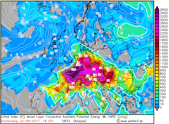
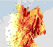
Instability was present on that day, as seen on Figure 1 below. The color pattern shows the Convective Available Potential Energy (CAPE), which is an indicator for atmospheric instability. In Europe, a value of 2000 Joules/kilogram (pink colors) can be considered large enough to produce convection, with the diagram showing that CAPE exceeded this threshold in most regions of central Europe. The small numbers represent the Lifted Index, which is another measure for instability. When the Lifted Index is below minus six, the atmosphere is considered as very unstable and SCS are likely to occur.
Figure 1: Map of Convective Available Potential Energy (CAPE) and Lifted Index on June 22
On the same day, June 22, a strong mid-level westerly jet streak developed over northwest Germany, associated with a short-wave upper trough. Ahead of this trough, backing winds provided the atmospheric conditions for SCS. A line of quasi-linear convective storms (QLCS), or squally thunderstorms developed in this region, and tracked east with the movement of the upper trough. Several of these QLCS likely coalesced into Mesoscale Convective Storms across central Germany, some of which reached as far east to produce supercell storms near Berlin. The moist airmass allowed these systems to continue to be very active for several hours, and the high moisture availability led to extreme rainfall accumulations and reports of very large hail.
Despite the available humidity and the high CAPE values in France, Belgium and the Netherlands, there was no major trigger over these regions, the storms could therefore not develop.
A Hurricane (Festival) is Threatened by Severe Weather
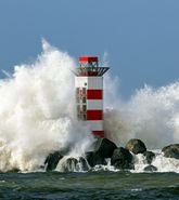
This system that moved across northern Germany on June 22 was a typical example of SCS, combining all three sub-perils – hail, wind and tornado. During this event, hailstones up to six centimeters in diameter and wind gusts up to 30 meters per second (67 miles per hour) were observed in Germany. In addition, a tornado was widely reported in the southern part of Hamburg.
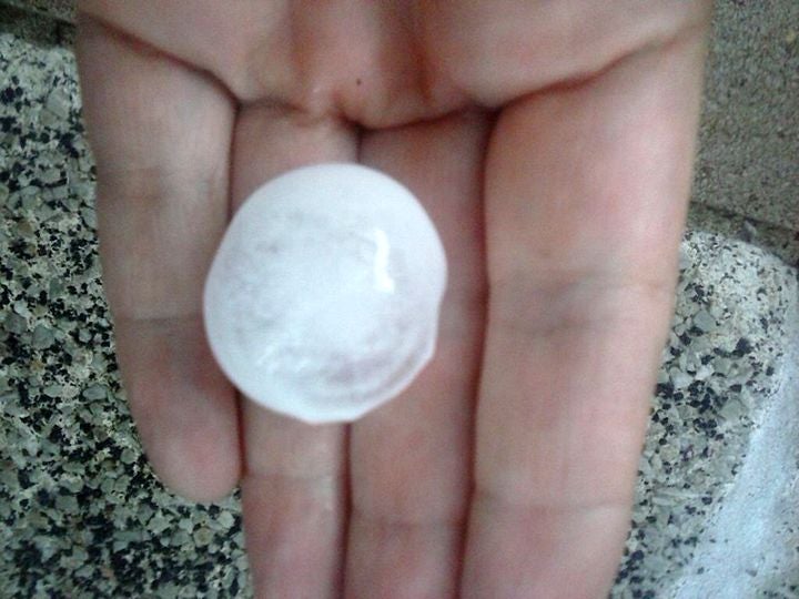
Figure 2: Two-centimeter hailstones observed 60 kilometers (37 miles) south of Hamburg. Source: RMS
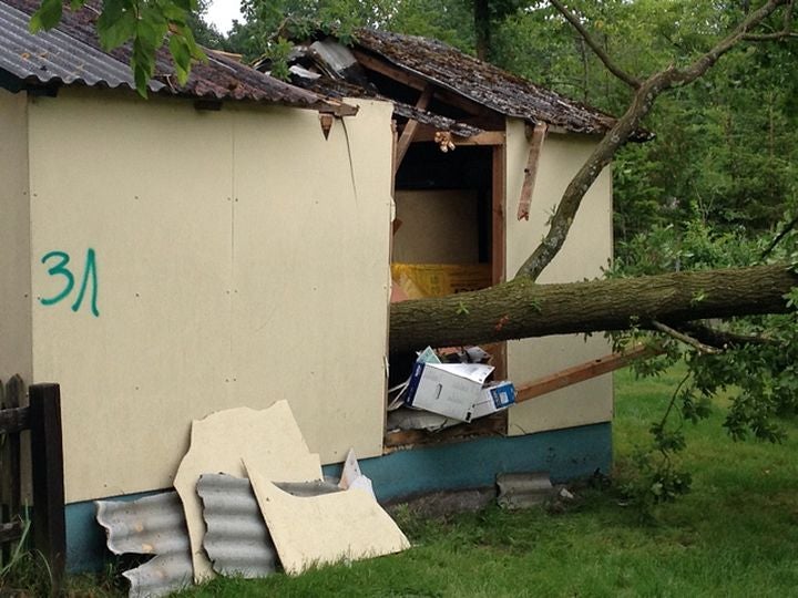
This situation caused disruption to the traffic and rail network, mostly caused by tree falls onto the roads and train tracks. Even the first day of the Hurricane Music Festival held at the Eichenring in Scheßel, between Bremen and Hamburg, was also impacted with organizers having to find shelters for the public.
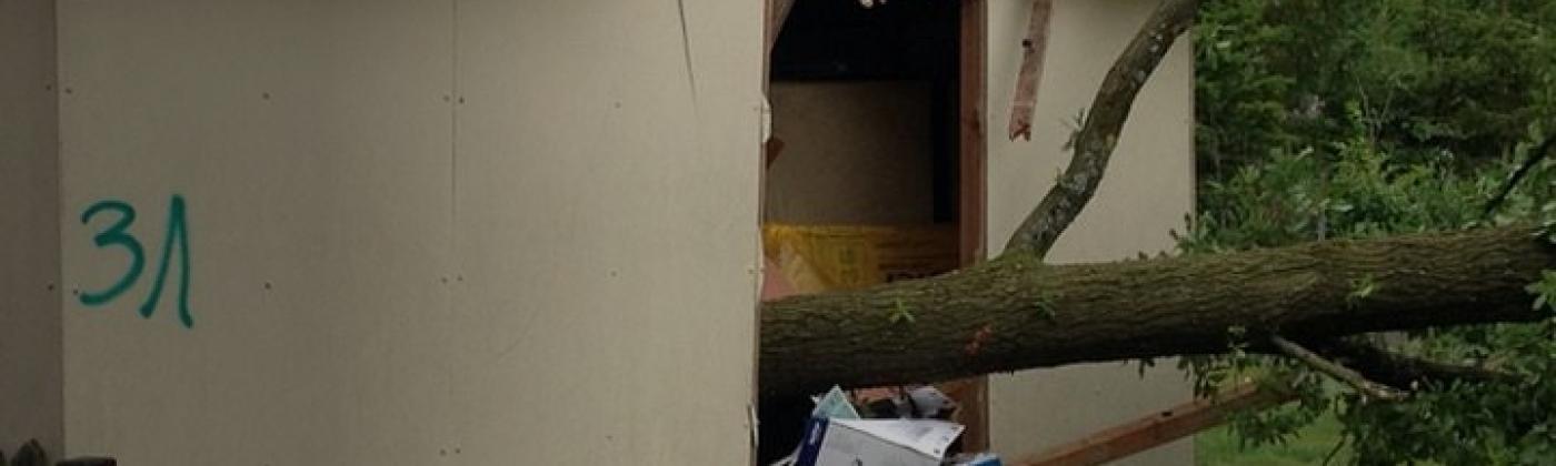
Figure 3: Shelter damaged by a tree fall. Picture was taken about 60 kilometers (37 miles) south of Hamburg. Source: RMS
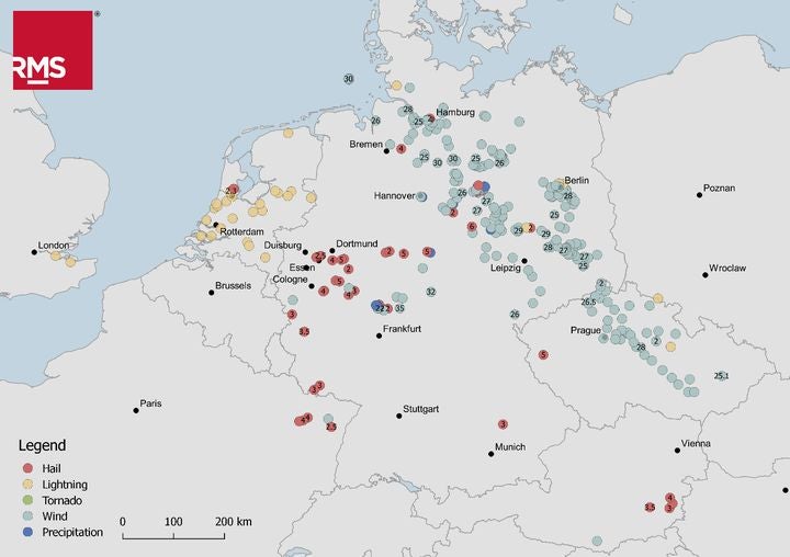
Figure 4 shows the observations reported in the European Severe Weather Database. Although all these observations are associated to a single system, we can clearly see that different sub-perils occurred in different regions. Hail seems to have been more reported in the western part of Germany, while strong wind gusts seem to have affected the northeastern part, moving all the way down to Czech Republic.
Figure 4: Severe Convective Storm observations reported in the European Severe Weather Database on June 22, 2017. The numbers within the circles correspond to the hazard values when available (hail diameter in centimeters or wind gust in meters per second)
This shows the difficulty of modeling SCS. Even if the event footprint is known, if it is based on radar data for example, a different sub-peril might occur in a different part of the system, producing very different types of damage. This figure also shows the bias present in observation data: for example, we see here that there are many more lightning reports in the Netherlands than in Germany. In addition, observations are mainly reported in populated area.
Towards a Better Management of Severe Convective Storm Risk
Despite the short lifetime and the localized impact of this event, losses are estimated to cost several tens of millions of euros, mostly affecting agricultural areas. Damage to vehicles were also reported, mainly due to tree falls. The story could however have been completely different if the thunderstorms had directly hit city centers.
This SCS example highlights some of the challenges of modeling this type of peril: the localized nature of these events makes the damages and losses very sensitive to the locations they hit. This also has consequences on observations being biased towards populated areas: unlike extra-tropical cyclones which have very wide footprints, SCS events can easily sneak through two weather stations.
Because of this, proxies are often used to model SCS events. However, as we have seen in the above example, even if the proxy data can provide the event extent, different sub-perils can lie in different parts of the footprints, requiring good understanding of sub-peril correlation.
RMS has over two decades of experience in modeling SCS, with one decade of experience in European severe weather risk modeling (HailCalc, Europe Windstorm Summer Winds) and our in-house experts continuously contribute to research on this topic. The release of the new RMS Europe Severe Convective Storm HD Models will provide a complete view of severe weather events, by including latest research on SCS modeling, sub-peril correlation and an innovative method to assess risks associated with automobile business lines.
Share:
You May Also Like
February 21, 2023
One Year Since Dudley, Eunice, and Franklin: Understanding Windstorm Clustering in Europe
Michèle joined RMS in 2013, and is based at the Moody's RMS Zurich office as part of the Global Climate Product Management team, focusing on European climatic hazard models. As part of her role, Michèle is the senior product manager for the new Moody's RMS Europe Windstorm HD Models and the Moody's RMS Europe Severe Convective Storm HD Models.
She holds a master’s degree in Atmospheric and Climate Science from ETH Zurich.
Based in London, James works as a Senior Modeler within the RMS Event Response team, supporting real-time event response operations and assisting on various event response projects. James holds a bachelor’s degree in Physical Geography and Geology from the University of Southampton and a master’s degree in Applied Meteorology from the University of Reading.
Juergen Grieser
Senior Director, Model Development
Juergen heads a group of modelers within Model Development, who are responsible for building RMS Severe Convective Storm and Winterstorm models.
During his fifteen years at RMS, Juergen has worked on several RMS models, leading the development of the Japan typhoon surge model, and the development of the tropical-cyclone rain model, and has also contributed to the European Winterstorm model.
Before joining RMS, Juergen worked for the United Nations Food and Agriculture Organization (FAO) and is also a contributing author of the Intergovernmental Panel on Climate Change (IPCC) Fourth Assessment report, which won the Nobel Peace Prize in 2007.
Juergen studied meteorology in Frankfurt, Germany, and holds a PhD in geosciences with a thesis on climate change detection in observations.