The 2013 Atlantic Hurricane Season: Historically Quiet or Just Getting Started?
Jeff WatersSeptember 15, 2013
It’s no secret. Despite consistent forecasts of another above average season and an uptick in activity over the last few days, the 2013 Atlantic Hurricane season got off to a historically quiet start. Of the nine named storms that have formed thus far, only two have reached hurricane strength (Humberto on September 11 and Ingrid on September 15). It is the first season in 11 years without a recorded hurricane by the end of August, and only the second season since 1944 where a hurricane had not formed by the climatological peak of hurricane season (September 10).
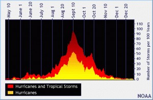
Number of tropical cyclones that form per 100 years in the Atlantic Basin
Part of the reason behind the slow start is the large amount of dry Saharan air pushing sand and dust into the atmosphere off of the west coast of Africa, effectively stabilizing the atmosphere and disrupting tropical waves from developing off the African coast. Also, strong wind-shear in the upper atmosphere and cooler-than average sea-surface temperatures (SSTs) in the eastern Atlantic have combined to suppress tropical cyclone development and intensification even further.
Some scientists are suggesting that this is the beginning of a bigger trend in hurricane activity given the changing climate, where warmer atmospheric conditions may act to reduce the likelihood of hurricane landfalls along the Atlantic Coast due to stronger atmospheric winds blowing west to east during hurricane season, effectively pushing storms away from the U.S.
Such findings are consistent with RMS’ new Medium-Term Rates (MTR) forecast, which was released earlier this year as part of the Version 13.0 North Atlantic Hurricane Model suite. Informed by an original study that involved simulating over 20 million years of hurricane activity under various SST regimes, we found that the proportion of land falling hurricanes decreases as SSTs increase.
Despite the relatively calm beginning, there is no indication that the second half of the season would resemble the first half.
As a comparison, the 1988 season didn’t produce a storm of hurricane strength until September 2, but eventually went on to produce Hurricane Gilbert, a Category 5 event in Mexico and the Caribbean that caused more than $7 billion USD in economic damage as the most powerful Atlantic hurricane on record until Hurricane Wilma in 2005.
Similarly, the first hurricane of the 2001 season, Hurricane Erin, formed on September 9, yet that season ended with 15 named storms including 9 hurricanes, 4 of which reached major hurricane status.
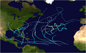
This chart below shows the tracks of all tropical cyclones in the 2012 Atlantic hurricane season. The points denote the location of each storm at 6-hour intervals, while the colors and symbols signify the storm’s intensity and corresponding category at each interval, respectively.
Hurricane tracks for the 2012 Atlantic Hurricane season
Climatologically, September is the busiest month for tropical cyclones in the Atlantic, producing an average of 3.5 named storms annually, 2.4 of which become hurricanes. In fact, of the 280 hurricanes that made landfall in the U.S. since 1851, over one-third of them (104) occurred in September.
It is at this time of the year when the tropical conditions are most conducive for tropical cyclone formation and development: Atlantic SSTs are at their warmest (generally in excess 26°C or 80°F), the tropical atmosphere is unstable and favorable for convection (i.e. thunderstorms), vertical wind shear is low, and there is usually a peak in frequency of rotating, low-level disturbances moving off of Africa across the tropics, which are the systems that eventually become tropical cyclones.
This month marks the notable anniversaries of several historic September hurricanes.
The 1903 Vagabond Hurricane celebrates its 110th anniversary on September 16, being the most recent hurricane to make first landfall in the state of New Jersey
Shortly thereafter on September 18 is the 10th anniversary of Hurricane Isabel, one of the top 5 costliest Mid-Atlantic hurricanes of all time
After that, September 21 marks the 75th anniversary of the 1938 New England Hurricane, the most intense and deadliest hurricane in New England history
Toward the end of the month is the 15th anniversary of Hurricane Georges on September 25, which made landfall in at least 7 different countries including the U.S. and at the time, was the costliest hurricane since Hurricane Andrew (1992)
With nearly half of the season to go, the 2013 Atlantic hurricane season may end up being one of the quietest seasons on record. However, as we have seen in years past, it also may be just getting started.
Share:
You May Also Like
September 27, 2023
Moody’s RMS North Atlantic Hurricane Models: Five Reasons Why Version 23 is the Right Model to Navigate a Challenging Market
Staff Product Manager, Model Product Management, Moody's RMS
Jeff Waters joined Moody's RMS in 2011 and is based in Bethlehem, PA. As part of the Product Management team, he is responsible for product management of the Moody's RMS North Atlantic Hurricane Models.
Jeff provides technical expertise and support regarding catastrophe model solutions and their applications throughout the (re)insurance industry. He also generates product requirements for future updates and releases, and helps develop the overall product strategy, messaging, thought leadership, and collateral to ensure its commercial and technical success.
Waters’ background is meteorology and atmospheric science with a focus in tropical meteorology and climatology. Jeff holds a B.S. in Geography/Meteorology from Ohio University (’09), and a M.S. in Meteorology from Penn State University (’11). He is a member of the American Meteorological Society, the International Society of Catastrophe Managers, and the U.S. Reinsurance Under 40s Group, Inc