Central Europe is still recovering from the massive flooding that followed one of the wettest months of May in recorded history for this region. In late May and early June, a period of intense rainfall caused major river systems, including the Danube and Elbe, which were already flowing above normal levels, to swell rapidly and burst their banks. Further showers and thunderstorms raised river levels higher, bringing localized flash floods.
Flooding near the source of precipitation occurred rapidly but destruction spread as the flood wave propagated downstream over the following week, impacting numerous cities over a vast area. Dike overtopping and breaching was common during this event, with significant on-floodplain flooding. Large areas of Germany, Austria, and the Czech Republic were seriously affected, while Switzerland, Poland, Slovakia, Hungary, Croatia, and Serbia were also impacted to lesser extents.
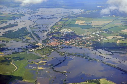
June 10, 2013 flooding and overflow of the banks of the Elbe along the lower course at Havelberg in Saxony-Anhalt. (Source: Euroluftbild.de/Grahn CC-BY-SA-3.0 http://creativecommons.org/licenses/by-sa/3.0)
According to Aon Benfield, the Central Europe floods were the costliest economic disaster during the first half of 2013—and the costliest to insurers, with expected payouts of US$5.3 billion (£3.5 billion) or more, with Germany experiencing the greatest loss.
This was a very different type of event to last year’s 2012 U.K. floods, where the sheer persistence of rainfall throughout the year saturated the soil and raised groundwater levels. Consequently, numerous small-scale, off-floodplain floods were observed, with surface water or pluvial flooding composing a significant component of the total insured loss.
Although most individual event losses were not notable, 2012’s estimated accumulated loss reached US$1.8 billion (£1.2 billion) (the second largest U.K. flood-related insured loss after the 2007 floods.
The contrasting nature of the past two years of attritional and catastrophic European floods raises the question: How can the insurance industry effectively manage flood risk in the face of such a widespread and variable peril? And, what role should the government play in mitigating the risk?
In part, government spending on flood defenses helps to manage the hazard; as demonstrated in Prague this year, where new defenses successfully protected vulnerable locations. However, budgets for such schemes are finite, meaning some regions will remain vulnerable and defense schemes are often targeted towards protecting against flooding in the floodplain or at the coast, which will not protect against the type of inland flooding observed in the U.K. in 2012.
For properties that remain in vulnerable locations, affordable insurance is their only means of protection but the frequency and severity of the hazard at such locations, makes it challenging for the insurance industry to offer affordable cover.
While there are positive initiatives on the horizon, such as the proposed Flood Re scheme in the U.K. (a government and industry backed flood pool), which is planned to replace the existing Statement of Principles (a voluntary commitment by the U.K. insurance industry). Making such schemes work requires a comprehensive evaluation of the hazard; a piecemeal approach will not suffice.
As demonstrated in the U.K. in 2012, it is necessary to consider all sources of flooding on- and off- the floodplain, including surface water flooding. The sheer scale of the 2013 Central European floods also showed that this peril can’t be viewed through the constraints of geographical boundaries; rather, large-scale catchments must be assessed.
In 2016 RMS will release a new and expanded pan-European inland flood model. The model will cover 13 at-risk countries, including those affected in 2012 and 2013, to comprehensively and consistently evaluate the risk from all sources of inland flooding, considering all underlying aspects of the hazard, at a high resolution across Europe. The scale and resolution of this model will, for the first time, enable the (re)insurance industry to assess European flood risk in a coherent manner, with the level of detail required to manage this dynamic and extreme peril.
Share:
You May Also Like
January 15, 2015
Lessons Hidden In A Quiet Windstorm Season
Wind gusts in excess of 100mph hit remote parts of Scotland earlier this month as a strong jet stream brought windstorms Elon and Felix to Europe. The storms are some of the strongest so far this winter; however, widespread severe damage is not expected because the winds struck mainly remote areas.
These storms are characteristic of what has largely been an unspectacular 2014/15 Europe windstorm season. In fact the most chaotic thing to cross the North Atlantic this winter and impact our shores has probably been the Black Friday sales.
This absence of a significantly damaging windstorm in Europe follows on from what was an active winter in 2013/14, but which contained no individual standout events. More detail of the characteristics of that season are outlined in RMS’ 2013-2014 Winter Storms in Europe report.
There’s a temptation to say there is nothing to learn from this year’s winter storm season. Look closer, however, and there are lessons that can help the industry prepare for more extreme seasons.
What have we learnt?
This season was unusual in that a series of wind, flood, and surge events accumulated to drive losses. This contrasts to previous seasons when losses have generally been dominated by a single peril—either a knockout windstorm or inland flood.
This combination of loss drivers poses a challenge for the (re)insurance industry, as it can be difficult to break out the source of claims and distinguish wind from flood losses, which can complicate claim payments, particularly if flood is excluded or sub-limited.
The clustering of heavy rainfall that led to persistent flooding put a focus on the terms and conditions of reinsurance contracts, in particular the hours clause: the time period over which losses can be counted as a single event.
The season also brought home the challenges of understanding loss correlation across perils, as well as the need to have high-resolution inland flood modeling tools. (Re)insurers need to understand flood risk consistently at a high resolution across Europe, while understanding loss correlation across river basins and the impact of flood specific financial terms, such as the hours clause.
Unremarkable as it was, the season has highlighted many challenges that the industry needs to be able to evaluate before the next “extreme” season comes our way.…
What to expect this 2014-2015 Europe Winter Windstorm Season
When it rains in Sulawesi it blows a gale in Surrey, some 12,000 miles away? While these occurrences may sound distinct and uncorrelated, the wet weather in Indonesia is likely to have played some role in the persistent stormy weather experienced across northern Europe last winter.
Weather events are clearly connected in different parts of the world. The events of last winter are discussed in RMS’ 2013-2014 Winter Storms in Europe report, which provides an in-depth analysis of the main 2013-2014 winter storm events and why it is difficult to predict European windstorm hazard due to many factors, including the influence of distant climate anomalies from across the globe.
Can we predict seasonal windstorm activity during the 2014-2015 Europe winter windstorm season?
As we enter the 2014-2015 Europe winter windstorm season, (re)insurers are wondering what to expect.
Many consider current weather forecasting tools beyond a week to be as useful as the unique “weather forecasting stone” that I came across on a recent vacation.
I am not so cynical; while weather forecasting models may have missed storms in the past and the outputs of long-range forecasts still contain uncertainty, they have progressed significantly in recent years.
In addition, our understanding of climatic drivers that strongly influence our weather, such as the North Atlantic Oscillation (NAO), El Niño Southern Oscillation (ENSO), and the Quasi-Biennial Oscillation (QBO) is constantly improving. As we learn more about these phenomena, forecasts will improve, as will our ability to identify trends and likely outcomes.
What can we expect this season?
The Indian dipole is an oscillation in sea surface temperatures between the East and West Indian Ocean. It has trended positively since the beginning of the year to a neutral phase and is forecast to remain neutral into 2015. Indonesia is historically wet during a negative phase, so we are unlikely to observe the same pattern that was characteristic of winter 2013-2014.
Current forecasts indicate that we will observe a weak central El Niño this winter. Historically speaking this has led to colder winter temperatures over northern Europe, with a blocking system drawing cooler temperatures from the north and northeast.
The influence of ENSO on the jet stream is less well-defined but potentially indicates that storms will be steered along a more southerly track. Lastly, the QBO is currently in a strong easterly phase, which tends to weaken the polar vortex as well as westerlies over the Atlantic.
Big losses can occur during low-activity seasons
Climatic features like NAO, ENSO, and QBO are indicators of potential trends in activity. While they provide some insight, (re)insurers are unlikely to use them to inform their underwriting strategy.
And, knowing that a season may have low overall winter storm activity does not remove the risk of having a significant windstorm event. For example, Windstorm Klaus occurred during a period of low winter storm activity in 2009 and devastated large parts of southern Europe, causing $3.4 billion in insured losses.
Given this uncertainty around what could occur, catastrophe models remain the best tool available for the (re)insurance industry to evaluate risk and prepare for potential impacts. While they don’t aim to forecast exactly what will happen this winter, they help us understand potential worst-case scenarios, and inform appropriate strategies to manage the exposure.…
As a member of RMS' model solutions team, Adrian works to guide more informed usage of catastrophe models and enhance understanding of model uncertainty. This requires interaction with the market, as well as other important stakeholders such as regulators and rating agencies, to help RMS develop tools that capture the evolving needs of the risk management industry. Based in London, his primary focus is on supporting the RMS European modeling suite. Adrian holds a BS in meteorology and oceanography from the University of East Anglia and an MS in engineering in the coastal environment from the University of Southampton.